
Daman Ganga River (redirect from Damanganga River)
There is an existing major irrigation project on the river called the Damanganga Reservoir Project, which is located near Madhuban village in Dharampur...
18 KB (2,066 words) - 16:12, 7 June 2024

Surat is about 120 km to the north. The Arabian Sea, at the delta of the Damanganga, is about 7 km to the west. The city has tropical weather and enjoys three...
9 KB (949 words) - 18:38, 17 August 2024
Chapora River Chenab river Cheyyar river Chitravathi River Coovum River Damanganga River Darshan River Deo River Devi River Daya River Damodar River Doodhna...
25 KB (2,100 words) - 18:27, 18 August 2024

top, left to right: Vanganga Garden, Silvassa; St. Thomas Church, Diu; Damanganga river, Silvassa; Diu Fort, Diu; St. James Church, Daman; Naida Caves,...
10 KB (737 words) - 15:13, 8 August 2024
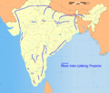
1) Srisailam–Pennar Link (link canals constructed and in use) (Part 1) Damanganga–Pinjal Link (Feasibility study complete) (Part 2) Kattalai–Vaigai–Gundar...
65 KB (6,346 words) - 06:08, 30 August 2024

at the signing ceremony of a tripartite MoU for preparation of DPR of Damanganga-Pinjal Link Project and Par-Tapi-Narmada Link Project, in New Delhi on...
31 KB (1,352 words) - 20:51, 30 August 2024
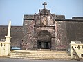
Jerónimo is a former Portuguese fortress located on the right bank of the Damanganga River, on the coast of the Gulf of Khambat, former parish of Damão Pequeno...
6 KB (676 words) - 18:53, 21 August 2024
guj-nwrws.gujarat.gov.in, Government of Gujarat. Retrieved 13 March 2012. "Damanganga River". guj-nwrws.gujarat.gov.in, Government of Gujarat. Retrieved 13...
18 KB (887 words) - 18:38, 9 February 2024

Par, Tapi & Narmada Maharashtra & Gujarat DPR Completed 13 Damanganga - Pinjal link Damanganga & Pinjal Maharashtra & Gujarat DPR Completed 14 Bedti - Varda...
141 KB (4,767 words) - 02:11, 2 September 2024

Sabarmati West Banas Shetrunji Bhadar Aji Ghela Rukmavati Vishwamitri Damanganga According to the WWF, Gujarat covers portions of five terrestrial ecoregions:...
6 KB (872 words) - 15:09, 12 July 2024

2000 mm Average temperature 26.9 °C Seismic Zone Zone III Major rivers Damanganga, Par, Auranga, Kolak, Taan and Maan Hills Parnera Hill, Wilson Hills Beaches...
24 KB (2,062 words) - 11:05, 10 March 2024

the land is almost plain and the soil is fertile and rich. The river Damanganga rises in the Ghat 64 km from the western coast and discharges itself in...
48 KB (5,184 words) - 21:53, 23 August 2024
of Kutch, Saurashtra and the territories between the rivers Banas and Damanganga. Islam came early to Gujarat, with immigrant communities of Arab and Persian...
59 KB (7,329 words) - 02:31, 20 August 2024
of Vapi city in Gujarat. It is also connected to Madhuban reservoir of Damanganga river and it becomes polluted from Morai village of Vapi where it meets...
3 KB (156 words) - 16:59, 1 May 2023

Maharashtra it is reported from Bombay presidency north of 19 degree (Thana and Damanganga districts, Bulsar, Panch Mahal), C.P(Nagpur) and Amravati. In Gujarat;...
5 KB (523 words) - 03:40, 26 February 2023
Geographically, Konkan is defined roughly as the area between the river Damanganga to the north and river Kali to the south, the north–south length being...
6 KB (745 words) - 18:27, 12 July 2024