Deuli is a census town in the Narayangarh CD block in the Kharagpur subdivision of the Paschim Medinipur district in the state of West Bengal, India. 8km...
10 KB (621 words) - 22:00, 24 April 2024
Deuli may refer to: Deuli, Bangladesh Deuli, India Deuli, Canning, census town in South 24 Parganas district, West Bengal, India This disambiguation page...
364 bytes (54 words) - 13:03, 17 November 2019
Deuli is a village and a gram panchayat within the jurisdiction of the Jibantala police station in the Canning II CD block in the Canning subdivision...
12 KB (613 words) - 20:40, 22 December 2024
Jaraka (section Deuli Hill and view point)
Cuttack Road, Gopabandhu Chhak and Shanti Baazar. To the north of the town, Deuli Hill is present on the banks of Brahmani River. The arrival of innovation...
6 KB (474 words) - 20:27, 22 December 2024

Lutunia R Khandrui R Keshiary R Kashmuli R Dhaneswarpur R Dantan R Belda R Deuli CT Chaulia CT Kurumbera Fort is situated in a village named Gaganeshwar...
9 KB (601 words) - 10:13, 20 August 2024
Baghmara, Jharkhand (category India geography stubs)
of Jharkhand,India.The nearest railway station to Baghmara is Rakhitpur Station. Baliapur police station serves Baghmara Village. Deuli-Khairpal Road...
3 KB (82 words) - 09:58, 12 July 2024
Canning Purba Assembly constituency is composed of the following: Deuli-I, Deuli-II, Kalikatala, Matherdighi, Sarengabad, Tambuldaha-I and Tambuldaha-II...
15 KB (583 words) - 19:09, 13 November 2024
Lutunia R Khandrui R Keshiary R Kashmuli R Dhaneswarpur R Dantan R Belda R Deuli CT Chaulia CT Belda is located at 22°05′N 87°21′E / 22.08°N 87.35°E...
12 KB (829 words) - 16:36, 10 October 2024
Lutunia R Khandrui R Keshiary R Kashmuli R Dhaneswarpur R Dantan R Belda R Deuli CT Chaulia CT Narayangarh is located at 22°10′02.6″N 87°23′05.6″E /...
11 KB (503 words) - 06:16, 3 September 2024

West Bengal is the state with the second highest population density in India. The state is dotted with several large and medium cities and towns. Historically...
27 KB (425 words) - 04:54, 8 February 2025

Kakatpur (category Port cities in India)
back to the 15th century A.D and the deity belongs to the 9th century A.D. Deuli Matha Kakatpur is a part of Kakatpur Assembly Constituency. Current MLA...
8 KB (508 words) - 20:15, 27 January 2025
Lutunia R Khandrui R Keshiary R Kashmuli R Dhaneswarpur R Dantan R Belda R Deuli CT Chaulia CT Sabang is located at 22°10′58.8″N 87°35′56.4″E / 22.183000°N...
12 KB (598 words) - 03:02, 17 June 2023
Nepal Nag (category Prisoners and detainees of British India)
completing high school. Nag was first arrested on 21 April 1932 and was sent to Deuli prison camp for seven years, where he took part in Communist consolidation...
5 KB (332 words) - 06:55, 19 September 2024

(PDF) from the original on 22 September 2020. Retrieved 28 January 2020. "Deuli, Harup and Suisa, Crumbling Temples, Scattered Statues and Single Room Museum"...
15 KB (749 words) - 11:22, 7 October 2024
Pushpagiri Vihara (category Buddhist monasteries in India)
khondalite pillars; this dates from the Mauryan period in the 3rd century, BCE. Deuli, a hill situated in the confluence of the Brahmani and Kimiria rivers, has...
18 KB (1,562 words) - 13:45, 22 November 2024
Lutunia R Khandrui R Keshiary R Kashmuli R Dhaneswarpur R Dantan R Belda R Deuli CT Chaulia CT Dantan is located at 21°54′38.2″N 87°16′12.0″E / 21.910611°N...
11 KB (510 words) - 23:31, 17 April 2024
Nabakalebara 2015 (category Religious festivals in India)
Journey to Deuli Matha. Daitapati's will leave Jagannath Ballava Ashram and will stay at Nua river Bank Ashram. 2 April 2015, Thursday: Stay at Deuli Matha...
23 KB (2,663 words) - 17:35, 26 August 2024

block consists of rural areas with 16 gram panchayats and one census town: Deuli. Keshiari community development block consists of only rural areas with...
37 KB (2,420 words) - 06:36, 20 November 2024

Lok Sabha constituency is one of the 543 Parliamentary constituencies in India. The constituency centres on Jadavpur in West Bengal. In All of the seven...
40 KB (630 words) - 18:27, 12 January 2025
Rajuar (category Ethnic groups in India)
population in Mayurbhanj was 1014 and distributed in Nij Majhalbagh (4), Deuli (34), Asankhali (459) and Khanua (44) of Baripada subdivision; Gartal (6)...
14 KB (1,187 words) - 16:27, 9 January 2025
Tulin, Purulia (redirect from Tulin india)
Directorate of Census Operations, West Bengal. Retrieved 28 January 2020. "Deuli, Harup and Suisa, Crumbling Temples, Scattered Statues and Single Room Museum"...
11 KB (508 words) - 12:33, 7 October 2024

Atharobanki, Deuli-I, Deuli-II, Kalikatala, Matherdighi, Narayanpur, Sarengabad, Tambuldaha-I and Tambuldaha-II. As per 2011 Census of India, Canning II...
34 KB (3,448 words) - 15:55, 16 January 2025
Directorate of Census Operations, West Bengal. Retrieved 28 January 2020. "Deuli, Harup and Suisa, Crumbling Temples, Scattered Statues and Single Room Museum"...
14 KB (653 words) - 13:19, 7 October 2024
Mathurapur is one of the 543 Parliamentary constituencies in India. The constituency centres on Mathurapur in West Bengal. All the seven legislative assembly...
22 KB (502 words) - 13:36, 31 October 2024
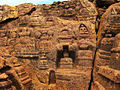
Chandil-Muri line. A ruined deul near Suissa A small deul at Deuli near Suissa Tirthankar statue inside Deuli temple "C.D. Block Wise Primary Census Abstract Data(PCA)"...
13 KB (607 words) - 11:04, 7 October 2024

subdivision of the Paschim Medinipur district in the state of West Bengal, India. It is on the bank of the Shilabati river. Gar in Bengali means a nullah...
19 KB (1,476 words) - 04:19, 24 January 2025
subdivision of the Paschim Medinipur district in the state of West Bengal, India. 8km 5miles Bhadutola Reserve Forest Godapiasal Forest Arabari Range Forest...
13 KB (594 words) - 21:03, 26 August 2024

(Bhola 1) and Nurunnabi Chowdhury (Bhola-3) Monpura char Char Kukri Mukri Deuli Dhal Char Manpura landing station Taruia Seabeach Sahabazpur gas field Jakob...
18 KB (1,290 words) - 08:33, 23 January 2025
Lutunia R Khandrui R Keshiary R Kashmuli R Dhaneswarpur R Dantan R Belda R Deuli CT Chaulia CT Lutunia is located at 22°13′32.2″N 87°33′43.9″E / 22...
10 KB (415 words) - 08:24, 27 October 2021
Gangasagar (category Hindu pilgrimage sites in India)
pilgrims gather at Gangasagar for a holy dip. According to the 2011 Census of India, Gangasagar had a total population of 10,340, of which 5,228 (51%) were...
22 KB (1,526 words) - 13:37, 13 January 2025