The Donegal Corridor (Irish: Muinchinn Dúin na nGall) was a narrow strip of Irish airspace linking Lough Erne to the international waters of the Atlantic...
8 KB (757 words) - 18:10, 13 May 2024

unpublicised contraventions of this, such as permitting the use of the Donegal Corridor by Allied military aircraft, and extensive co-operation between Allied...
49 KB (6,463 words) - 06:04, 13 August 2024

aircraft. On 21 March 1941, an RAF Catalina flying boat (AM265) using the Donegal Corridor crashed into the mountain at Glenade, County Leitrim on the east side...
23 KB (2,380 words) - 13:40, 14 July 2024

Ballyshannon (redirect from Ballyshannon, Donegal)
Seanaidh, meaning 'the mouth of Seannach's ford') is a town in County Donegal, Ireland. It is located at the southern end of the county where the N3...
24 KB (2,329 words) - 20:55, 16 August 2024
in the United States, to be flown by the RAF. This was known as the Donegal Corridor. Navigational markings are still, faintly, visible on mountains, such...
61 KB (6,769 words) - 05:11, 9 July 2024
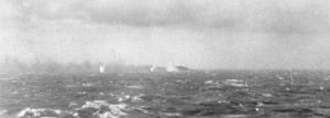
Atlantic from its base on Lough Erne in Northern Ireland across the Donegal Corridor. It was piloted by the British Flying Officer Dennis Briggs and co-piloted...
36 KB (4,596 words) - 14:22, 28 July 2024
numeric names: authors list (link) "The Donegal Corridor, A Contradiction of Irish Neutrality during WWII | Donegal Diaspora". www.donegaldiaspora.ie. Retrieved...
5 KB (616 words) - 17:29, 18 June 2024

initiating rearmament). Irish neutrality during World War II The Emergency Donegal Corridor Irish Naval Service Plan W Akrotiri and Dhekelia The UK refused to...
25 KB (3,501 words) - 18:47, 13 August 2024
Germany. Ireland also secretly allowed Allied aircraft to use the Donegal Corridor, making it possible for British planes to attack German U-boats in...
77 KB (4,987 words) - 05:23, 15 August 2024
Allied aircraft were allowed to access the Atlantic Ocean via the Donegal Corridor. German military personnel were interned in the Curragh along with...
39 KB (3,725 words) - 21:20, 16 August 2024
as well as allowing allied aircraft over Irish airspace through the Donegal Corridor and providing access to weather reports from the Atlantic Ocean which...
7 KB (614 words) - 17:04, 27 May 2023

aeroplanes based in Northern Ireland. This flight path became known as 'The Donegal Corridor'. An example of the many ways Ireland assisted the allies while remaining...
18 KB (2,154 words) - 08:47, 11 July 2024
neutral, tacitly supported the Allies in several ways. For example, the Donegal Corridor allowed British military aircraft based in County Fermanagh to fly...
64 KB (6,655 words) - 00:00, 23 July 2024
Archdale which was a flying boat base on Lough Erne and through the Donegal Corridor. The plane was primarily piloted by British Flying Officer Dennis Briggs...
5 KB (593 words) - 19:07, 11 March 2024

shipping traffic. London was informed when U-boats were sighted. The Donegal Corridor allowed British flying boats based on Lough Erne to take a short-cut...
68 KB (9,238 words) - 20:29, 7 August 2024

Germany. Ireland also secretly allowed Allied aircraft to use the Donegal Corridor, making it possible for British planes to attack German U-boats in...
38 KB (3,586 words) - 02:14, 8 May 2024

Finner Camp (category Buildings and structures in County Donegal)
Irish Free State in 1922. In the Second World War, it was close to the Donegal Corridor. In August 1969 there was false speculation in the media that Taoiseach...
3 KB (179 words) - 00:29, 12 January 2024

allowed aircraft to fly from Lough Erne to the Atlantic along the Donegal Corridor. In May 1941 the German battleship Bismarck was found during a routine...
8 KB (644 words) - 20:25, 15 May 2024

passes through nine counties and three provinces, stretching from County Donegal's Inishowen Peninsula in Ulster to Kinsale, County Cork, in Munster, on...
10 KB (702 words) - 10:41, 9 August 2024

invasion subsided The Irish government allowed RAF planes to fly the Donegal Corridor beginning in 1941. This was a contravention of Irish neutrality and...
70 KB (9,395 words) - 22:26, 24 April 2024
first flight by a British Royal Air Force flying boat through the "Donegal Corridor", Irish airspace between its base in Northern Ireland and the Atlantic...
12 KB (1,243 words) - 18:35, 3 April 2024
signs have been renovated such as the one in Loop Head, County Clare. Donegal Corridor Irish Neutrality WW2 Peter Homer, A Brief History of Malin Head, pp...
39 KB (548 words) - 14:10, 15 August 2024
February 21 – The first flight by a British RAF flying boat through the "Donegal Corridor", neutral Republic of Ireland airspace between its base in Northern...
87 KB (11,685 words) - 01:52, 27 June 2024

2021. Donegal still fighting the effects of partition Archived 2009-08-13 at the Wayback Machine - Joe McHugh TD, Donegal Matters, 20/08/08 Donegal County...
19 KB (1,638 words) - 10:06, 16 July 2024
February – First flight by a Royal Air Force flying boat through the "Donegal Corridor", neutral Republic of Ireland airspace between its base in Northern...
4 KB (386 words) - 22:31, 12 October 2023

RAF Castle Archdale on Lough Erne, in Northern Ireland, using the Donegal Corridor over neutral Eire. During this time, in May 1941, a patrol by No.209...
19 KB (1,188 words) - 06:00, 22 October 2023

Port and City of Derry Airport. Derry is close to the border with County Donegal, with which it has had a close link for many centuries. The person traditionally...
164 KB (15,557 words) - 23:43, 13 August 2024
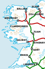
of a North-Western Rail Corridor is the suggested construction of a railway connecting Sligo, Bundoran, Ballyshannon, Donegal Town, Letterkenny and Derry...
41 KB (4,300 words) - 10:51, 28 July 2024

N15 road (Ireland) (category Roads in County Donegal)
Ireland. It runs from Sligo to Lifford, County Donegal. It forms part of the proposed Atlantic Corridor route. It also goes to the border with Northern...
11 KB (1,112 words) - 15:03, 31 January 2023
Ballybofey railway station (category Disused railway stations in County Donegal)
served the village of Ballybofey in County Donegal, Ireland. The station opened on 3 June 1895 on the Donegal Railway Company line from Glenties to Stranorlar...
3 KB (94 words) - 11:23, 30 October 2023