The Dunedin Southern Motorway is the main arterial route south from the South Island city of Dunedin, part of New Zealand's State Highway 1. Despite its...
15 KB (1,664 words) - 17:02, 27 July 2024
Southern Motorway can refer to one of several urban motorways within New Zealand: Auckland Southern Motorway Christchurch Southern Motorway Dunedin Southern...
205 bytes (54 words) - 04:32, 30 December 2019

length. It becomes the Dunedin Southern Motorway at its western end, close to Lookout Point. At its eastern end, it joins Dunedin's central city one-way...
17 KB (1,568 words) - 10:09, 23 July 2024

the saddle of Lookout Point. The four-lane motorway (Dunedin Southern Motorway) runs through Dunedin's southern suburbs until the interchange with SH 87...
54 KB (5,368 words) - 22:09, 22 July 2024
Caversham, New Zealand (redirect from Caversham, Dunedin)
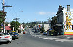
bypass skirts its main retail area, connecting Dunedin's one-way street system with the Dunedin Southern Motorway. The suburb is linked by several bus routes...
52 KB (6,668 words) - 23:59, 30 July 2024

Mosgiel (redirect from Seddon Park, Dunedin)
located at the foot of the hill. The Dunedin Southern Motorway, upgraded in 2003, links Mosgiel with the centre of Dunedin. State Highway 87 to Kyeburn starts...
27 KB (2,983 words) - 11:33, 31 July 2024

streets, including the Dunedin Southern Motorway extension along the southern edge of the Oval sports grounds and the southern end of Princes Street....
2 KB (212 words) - 08:06, 18 April 2024

State Highway 1 follows the eleven-kilometre Dunedin Southern Motorway. State Highway 88 connects central Dunedin to the city's port facilities at Port Chalmers...
111 KB (10,039 words) - 12:12, 7 August 2024
and Lookout Point. One of Dunedin's older suburban areas is Caversham, lying in a valley close to the Dunedin Southern Motorway (part of State Highway 1)...
23 KB (3,150 words) - 00:11, 17 April 2024
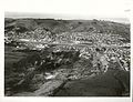
1979 Abbotsford landslip (category History of Dunedin)
also sloping, and quarrying and the construction of the nearby Dunedin Southern Motorway during the 1960s and early 1970s may have further affected the...
9 KB (1,276 words) - 07:26, 24 June 2024

Calton Hill, New Zealand (category Suburbs of Dunedin)
Road (where it terminates near the Dunedin Southern Motorway). The South Island Main Trunk railway and the motorway (part of State Highway 1) further distinguish...
17 KB (2,280 words) - 23:52, 30 July 2024

by William Martin. It is situated on Sickels Street near the Dunedin Southern Motorway. The school has restricted enrolment to a limited geographical...
2 KB (80 words) - 05:17, 14 April 2024

Dunedin–Waitati Highway (SH 1), formerly (and currently in official land-use planning contexts) called Dunedin Northern Motorway, is a two-to-four-lane...
7 KB (744 words) - 18:28, 9 June 2023

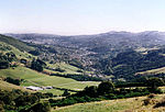
Kaikorai Valley (redirect from Kaikorai, Dunedin)
mouth, close to the junction of Kaikorai Valley Road and the Dunedin Southern Motorway, part of State Highway 1. The suburb of Kaikorai sits at the head...
10 KB (1,021 words) - 01:30, 7 April 2024

Princes Street, the northern end of Anderson's Bay Road, and the Dunedin Southern Motorway. Its name dates from 22 March 1864, when it was decided to enclose...
7 KB (606 words) - 23:13, 24 July 2024
Road) SH 1 becomes Dunedin Southern Motorway Mosgiel 720 450 SH 87 (Quarry Road) – Mosgiel 721 448 (Braeside) Dunedin Southern Motorway ends Allanton 729...
31 KB (34 words) - 10:47, 10 April 2024

Public transport in the Otago Region (redirect from GoBus (Dunedin))
The public transport system of Otago centres around the cities of Dunedin and Queenstown, under the brand name Orbus. Public transport in the region is...
22 KB (1,790 words) - 17:54, 31 March 2024

Two-lane expressway (redirect from Two-lane motorway)
Christchurch with Lyttelton is the limited-access Tunnel Road. In Dunedin, the Dunedin Southern Motorway has a short one-kilometre section which is only two-laned...
51 KB (6,360 words) - 23:56, 10 August 2024

Fairfield, Otago (redirect from Fairfield (Dunedin City))
now on a bypass of the Dunedin Southern Motorway. Fairfield is situated about 11 km (7 mi) west-southwest of the Octagon, Dunedin's city centre. As of the...
7 KB (715 words) - 00:31, 7 April 2024

State Highway 87 (New Zealand) (category Transport in Dunedin)
SH 87 leaves SH 1 at a junction at the southwestern end of the Dunedin Southern Motorway, immediately south of Mosgiel. It travels north through the town...
3 KB (250 words) - 22:25, 5 October 2023
Sunnyvale Park (category Sports venues in Dunedin)
Sunnyvale, near Green Island, and is bounded by Main South Road, Dunedin Southern Motorway and Abbot's Creek, a tributary of the Kaikorai Stream. The park is...
1 KB (136 words) - 02:14, 24 June 2022

Controlled-access highway (redirect from Motorway)
Christchurch, Hamilton, Tauranga, and Dunedin contain motorways, with only Auckland having a substantial motorway network. Roads portal U.S. Roads portal...
233 KB (24,905 words) - 22:33, 13 August 2024
Concord, New Zealand (category Suburbs of Dunedin)
Zealand city of Dunedin. It is southwest of the city centre. It lay on State Highway 1 until the construction of the Dunedin Southern Motorway in the 1990s...
5 KB (506 words) - 01:49, 25 February 2024
routes associated with it. A large motorway interchange lies in Burnside, with slip roads from the Dunedin Southern Motorway to Green Island and the Kaikorai...
8 KB (891 words) - 22:21, 29 June 2023
construction of the Dunedin Southern Motorway began in the 1970s. Very little remains of the Walton Park Branch. In 2000 the Southern Motorway extension was...
3 KB (388 words) - 01:36, 12 May 2022

Kaikorai Stream (category Rivers of Dunedin)
Island, mainly in a channel lined with concrete alongside the Dunedin Southern Motorway. Below Green Island, the stream is joined by major tributary Abbots...
16 KB (1,624 words) - 04:55, 12 April 2024

Water of Leith (New Zealand) (category Rivers of Dunedin)
much of Dunedin's drinking water. From the southern end of the Sullivan's Dam reservoir, the Leith flows southwest, passing under the motorway and through...
9 KB (1,051 words) - 01:32, 7 April 2024
2015 Otago flood (category History of Dunedin)
The NZTA also advised people to avoid travelling on the Dunedin Southern Motorway between Dunedin city centre and Mosgiel. In addition, foul sewer contamination...
31 KB (3,445 words) - 22:36, 30 July 2024
disciplines. Dunedin Hospital is the largest public hospital south of Christchurch. It has over 300 beds and is operated by the Southern District Health...
12 KB (1,330 words) - 19:28, 12 November 2023
North East Valley (redirect from Normanby, Dunedin)
and football pitches, and beyond this ground is the southern end of the Dunedin Northern Motorway, part of State Highway 1. The Gardens Ground is the...
14 KB (1,584 words) - 03:03, 23 February 2024