
The Erbeskopf (German pronunciation) is a mountain in the Hunsrück range in central Germany. At a height of 816 metres (2,677 ft), it is the highest point...
12 KB (1,258 words) - 11:54, 31 May 2024
Forest, the Soonwald, and the Bingen Forest. The highest mountain is the Erbeskopf (816 m; 2,677 ft), towards the region's south-west. Notable towns are...
31 KB (3,742 words) - 08:14, 20 August 2024
Thalfang am Erbeskopf is a Verbandsgemeinde ("collective municipality") in the district Bernkastel-Wittlich, in Rhineland-Palatinate, Germany. Its seat...
1 KB (57 words) - 18:16, 29 August 2018
Elmenhorst Döbern Gleina Döbraberg Großer Arber Meßstetten Freising Lauda Erbeskopf Brekendorf Brockzetel Visselhövede Auenhausen Marienbaum Erndtebrück Schönewalde...
98 KB (7,697 words) - 15:43, 12 September 2024

lower than the German average. Rhineland-Palatinate portal Butterpfad Erbeskopf Nürburgring "Bruttoinlandsprodukt, Bruttowertschöpfung | Statistikportal...
41 KB (3,221 words) - 07:10, 20 August 2024
Neunkirchen, Bernkastel-Wittlich, part of the Verbandsgemeinde Thalfang am Erbeskopf in Bernkastel-Wittlich district Neunkirchen am Potzberg, part of the Verbandsgemeinde...
1 KB (173 words) - 13:48, 1 April 2018
The wooded peak is the second-highest in Rhineland-Palatinate after the Erbeskopf (816.3 m), 15 kilometres to the southwest (with its southwestern spur...
3 KB (190 words) - 01:44, 21 October 2022
Wasserkuppe (950.0) Helpt Hills (179.2) Wurmberg (971.2) Langenberg (843.2) Erbeskopf (816.32) Dollberg (695.4) Fichtelberg (1214.8) Brocken (1141.2) Bungsberg...
16 KB (716 words) - 08:22, 23 February 2024

(244.97) Möhnesee (213.74) 96 Großer Feldberg (~880) Langenberg (843.2) Erbeskopf (816.32) Taufstein (773.0) Hohe Acht (746.9) Botrange (694.24) Donnersberg...
29 KB (2,178 words) - 18:33, 20 March 2022
Eifel and flow into the Moselle. In the very south of the district is the Erbeskopf (818 m), the highest peak in the Hunsrück and Rhineland-Palatinate. The...
5 KB (237 words) - 21:52, 25 March 2024

Three ??? mean unknown or not yet researched; please add information! Erbeskopf (816 m), Bernkastel-Wittlich district, Schwarzwälder Hochwald, Hunsrück...
19 KB (1,330 words) - 18:35, 14 March 2022
Elmenhorst Döbern Gleina Döbraberg Großer Arber Meßstetten Freising Lauda Erbeskopf Brekendorf Brockzetel Visselhövede Auenhausen Marienbaum Erndtebrück Schönewalde...
76 KB (5,245 words) - 18:51, 20 July 2024
Saar-Hunsrück Nature Park, running roughly from Mettlach in the Saarland to the Erbeskopf in Rhineland-Palatinate. It lies northwest of Losheim, Weiskirchen, Wadern...
4 KB (357 words) - 20:50, 20 August 2024

346 1,135 Lower Saxony Hümmling Windberg 73 240 Lower Saxony Hunsrück Erbeskopf 816 2,677 Rhineland-Palatinate Hütten Hills Scheelsberg 106 348 Schleswig-Holstein...
24 KB (142 words) - 11:46, 24 June 2024

unless otherwise stated these are referenced from state map service): Erbeskopf (816.32 m), Schwarzwälder Hochwald An den zwei Steinen (766.2 m), Idar...
8 KB (587 words) - 21:04, 30 December 2020

lies in the Hunsrück and belongs to the Verbandsgemeinde of Thalfang am Erbeskopf, whose seat is in the municipality of Thalfang. Beginning in the 12th...
3 KB (251 words) - 11:43, 6 August 2021

the Hunsrück. Merschbach belongs to the Verbandsgemeinde of Thalfang am Erbeskopf, whose seat is in the municipality of Thalfang. In 1281, Merschbach, which...
3 KB (261 words) - 11:49, 6 August 2021

middle of the Hunsrück, whose highest elevation is the Erbeskopf at 816 m above sea level. The Erbeskopf is roughly 6 km from the municipality as the crow...
4 KB (432 words) - 11:52, 6 August 2021

Neumagen-Dhron (Verbandsgemeinde) Saarburg (Verbandsgemeinde) Thalfang am Erbeskopf Traben-Trarbach (Verbandsgemeinde) Trier-Land Wittlich-Land Zell (Verbandsgemeinde)...
5 KB (177 words) - 15:34, 18 August 2023

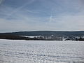
The Erbeskopf within the Hunsrück-Hochwald National Park...
1,016 bytes (75 words) - 18:04, 11 September 2022

Rhineland-Palatinate, Germany. It is the seat of the Verbandsgemeinde of Thalfang am Erbeskopf. The municipality lies in the western Hunsrück on the Hunsrückhöhenstraße...
6 KB (614 words) - 13:11, 2 May 2024

little outlier of the Soonwald); to the southwest, the Idarkopf and the Erbeskopf (mountains, the latter of which, at 816 m above sea level is Rhineland-Palatinate's...
27 KB (3,420 words) - 13:23, 4 August 2021
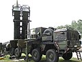
2014-05-09. 10 February 62 (U) Installation of mobile CPA-73 started atop Erbeskopf mountain. Air Weapons Control System 412L (Report No. 8). Vol. ADA 404...
8 KB (1,072 words) - 04:30, 1 September 2024

near Dillingen. Malborn belongs to the Verbandsgemeinde of Thalfang am Erbeskopf, whose seat is in the municipality of Thalfang. Malborn's Ortsteile are...
5 KB (498 words) - 13:07, 27 January 2024

and Trittenheim to Neumagen-Dhron; the mountains of the Eifel and the Erbeskopf – the highest elevation in Rhineland-Palatinate – the Dhron reservoir...
6 KB (528 words) - 18:08, 24 September 2023

lies in the Hunsrück and belongs to the Verbandsgemeinde of Thalfang am Erbeskopf, whose seat is in the municipality of Thalfang. In 1136, Rorodt had its...
2 KB (175 words) - 05:07, 9 August 2023

(Döbraberg) ± 30″ Hunsrück Erbeskopf 816 49°44′00″N 07°05′30″E / 49.73333°N 7.09167°E / 49.73333; 7.09167 (Erbeskopf) ± 30″ Elster Mountains Počátecký...
11 KB (509 words) - 15:40, 3 August 2024

the Moselle. Dhronecken belongs to the Verbandsgemeinde of Thalfang am Erbeskopf, whose seat is in the municipality of Thalfang. Dhronecken lies in what...
9 KB (1,085 words) - 11:42, 6 August 2021

elevation is the nearby Erbeskopf at 816 m above sea level. Talling belongs to the Verbandsgemeinde of Thalfang am Erbeskopf, whose seat is in the municipality...
5 KB (524 words) - 11:53, 6 August 2021

on the edge of, the Idar Forest: Dhron Idarbach (Nahe) - rises between Erbeskopf and Kahlheid Idarbach (Hahnenbach) - rises north of the Idarkopf near...
2 KB (204 words) - 15:10, 11 April 2023