
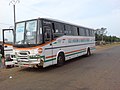
Gaya is a city in the Gaya Department of the Dosso Region of Niger. The city is situated 254 km southeast of the capital, Niamey, is located on the banks...
11 KB (865 words) - 12:42, 22 May 2024
a city in Bihar Gaya Airport Bodh Gaya, a town in Bihar near Gaya Gaya district, Bihar Gaya, Niger, a city in the Dosso region Gaya Department, a department...
2 KB (255 words) - 14:47, 4 July 2024
Gaya Airport (ICAO: DRRG) is an airport serving Gaya, Dosso Region, Niger, near the country's borders with Benin and Nigeria. It is located 2 kilometres...
2 KB (59 words) - 13:19, 18 May 2024

and Gaya. Niger has insufficient access to the energy it needs. The country's energy consumption is considered one of the lowest in the world. Niger's existing...
66 KB (6,184 words) - 13:16, 3 August 2024

Niger or the Niger, officially the Republic of the Niger, is a country in West Africa. It is a unitary state bordered by Libya to the northeast, Chad to...
145 KB (14,128 words) - 21:26, 29 June 2024
River bridge at Gaya crosses into Benin. Despite having no ocean or deep draft river ports, Niger does operate a port authority. Niger relies on the port...
18 KB (2,073 words) - 10:36, 24 June 2024

Malanville (Benin)-Gaya (Niger). It is also possible to travel via the W National Park, where the border itself is open. Benin-Niger relations CIA World...
6 KB (672 words) - 11:17, 4 February 2022
Ibrahim Maïga Burkina Faso Ahmed Nassar Egypt –74 kg Aboubacar Mangue Gaya Niger Rami Hussein Sherif Eissa Egypt Jean Kouamé Ivory Coast Hani Tebib...
11 KB (54 words) - 11:43, 1 April 2024
The regions of Niger are subdivided into 63 departments (French: départements). Before the devolution program on 1999–2005, these departments were styled...
8 KB (601 words) - 03:14, 15 July 2024
This is a list of cities and towns in Niger. All larger cities are also Communes of Niger. While often translated as "town", Nigerien communes are simply...
7 KB (198 words) - 08:08, 18 September 2023
Malanville (category Benin–Niger border crossings)
along the Bénin/Niger border, located 733 kilometres from Cotonou. It is connected to the city of Gaya, Niger via a bridge over the Niger River. It resides...
7 KB (422 words) - 04:00, 24 June 2024
overview of and topical guide to Niger: Niger – landlocked sovereign country located in West Africa. Niger was named for the Niger River. It borders Nigeria...
17 KB (1,112 words) - 19:04, 6 July 2024

Gaya is a department of the Dosso Region in Niger. Its capital lies at the city of Gaya. As of 2012, the department had a total population of 261,638...
4 KB (85 words) - 19:13, 22 February 2024

main ones being Gaya-Kamba, Birni-N'Konni-Ilela, Dan-Issa-Katsina and Magaria-Mutum. Niger-Nigeria relations CIA World Factbook - Niger, 3 November 2019...
6 KB (706 words) - 01:08, 22 April 2024
published in 1975, he explores the impact of the 1973 drought and famine in Niger, depicting how the natural disaster led to poverty and social disintegration...
4 KB (328 words) - 13:05, 5 August 2024

Lété Island (category Islands of Niger)
island in the Niger River, approx. 16 kilometres long and 4 kilometres wide, located around 40 kilometres from the town of Gaya, Niger. Together with...
2 KB (262 words) - 21:33, 11 March 2024
Niger pursues a moderate foreign policy and maintains friendly relations with both East and West. It is a member state of the United Nations. Niger maintains...
66 KB (4,060 words) - 22:23, 9 August 2024

The Niger River (/ˈnaɪdʒər/ NY-jər; French: (le) fleuve Niger [(lə) flœv niʒɛʁ]) is the main river of West Africa, extending about 4,180 kilometres (2...
49 KB (3,394 words) - 01:48, 10 July 2024
Dendi (province) (category Niger articles missing geocoordinate data)
incorporated into French West Africa. Its centers today are the cities of Gaya in Niger, Kamba in Nigeria and Malanville in Benin. Under the Songhai empire...
8 KB (865 words) - 13:44, 28 July 2024

taking flat-bottomed boats with 60 tons of provisions to French troops at Gaya, Niger. In another one of the great comebacks of baseball history, the Cleveland...
81 KB (10,591 words) - 19:32, 19 June 2024
Dendi people (category Ethnic groups in Niger)
633 people. Among them, only 4,505 live in Nigeria. In Niger they live in around the city of Gaya. Their mother tongue is Dendi. The Dendi and the Songhai...
5 KB (614 words) - 02:15, 6 March 2024
Aaya Ram Gaya Ram (lit. 'Ram has come, Ram has gone') is a Hindi expression referring to the practice of turncoating, or switching parties in the context...
7 KB (839 words) - 04:21, 1 July 2024

Niamey, Tillaberi, and Gaya. This brigade works closely with custom services to address fluvial and riverine trafficking on the Niger river. Training and...
10 KB (775 words) - 22:48, 3 January 2023

Agriculture is the primary economic activity of a majority of Niger's 17 million citizens. The agricultural economy is based largely upon internal markets...
13 KB (1,333 words) - 15:54, 8 December 2022

north Ndali Kandi Guéné Lama-Kara Malanville border (574 km) near Niger River bridge. Gaya (1,435 mm (4 ft 8+1⁄2 in) gauge Kano - junction (0 km) (capital...
7 KB (455 words) - 14:56, 7 September 2023
The Departments of Niger are subdivided into communes. As of 2005, in the seven Regions and one Capital Area, there were 36 départements, divided into...
12 KB (907 words) - 07:10, 7 March 2024
goods, exacerbating economic hardships in Niger. Several commercial and transit hubs in Niger, including Gaya, experienced drastic declines in business...
13 KB (1,394 words) - 05:01, 18 July 2024

Dosso Region (category Regions of Niger)
Dosso is one of the eight Regions of Niger. The region has an area of 31,002 square kilometres (11,970 sq mi), with a population of 2,754,500 as of 2020...
8 KB (595 words) - 10:53, 23 March 2024
Maouri people (category Ethnic groups in Niger)
groups of Niger, and are concentrated around the Dallol Maouri (Maouri Valley) of the Niger River, extending from Matankari, near Niamey, to Gaya. They are...
4 KB (383 words) - 15:29, 1 July 2024
The following are the telephone codes in Niger. • +227 ABPQMCDU The new National Numbering Plan (NNP) of Niger is structured as eight digits, in the following...
7 KB (105 words) - 06:34, 16 July 2023