
Geodesy or geodetics is the science of measuring and representing the geometry, gravity, and spatial orientation of the Earth in temporally varying 3D...
38 KB (4,268 words) - 13:13, 22 August 2024
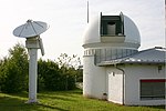
Satellite geodesy is geodesy by means of artificial satellites—the measurement of the form and dimensions of Earth, the location of objects on its surface...
21 KB (2,340 words) - 17:44, 23 August 2024

Space geodesy is geodesy by means of sources external to Earth, mainly artificial satellites (in satellite geodesy) but also quasars (in very-long-baseline...
471 bytes (50 words) - 09:45, 23 May 2022
The history of geodesy (/dʒiːˈɒdɪsi/) began during antiquity and ultimately blossomed during the Age of Enlightenment. Many early conceptions of the Earth...
100 KB (12,817 words) - 07:14, 18 August 2024
World Geodetic System (category Geodesy)
The World Geodetic System (WGS) is a standard used in cartography, geodesy, and satellite navigation including GPS. The current version, WGS 84, defines...
24 KB (2,843 words) - 13:42, 3 August 2024
Geodesy, also called Bomford's Geodesy, is a textbook on geodesy written by Guy Bomford. Four editions were published, in 1952, 1962, 1971, and 1980 respectively...
7 KB (732 words) - 01:22, 29 July 2024
Physical geodesy is the study of the physical properties of Earth's gravity and its potential field (the geopotential), with a view to their application...
6 KB (1,403 words) - 06:27, 26 July 2024
The Journal of Geodesy is an academic journal about geodesy published by Springer on behalf of the International Association of Geodesy (IAG). It is the...
2 KB (83 words) - 02:46, 16 February 2024
Geodetic datum (redirect from Datum (geodesy))
crucial to any technology or technique based on spatial location, including geodesy, navigation, surveying, geographic information systems, remote sensing...
31 KB (3,346 words) - 06:28, 11 August 2024

Very-long-baseline interferometry (redirect from International VLBI Service for Geodesy and Astrometry)
plates very precisely (within millimetres), and perform other types of geodesy. Using VLBI in this manner requires large numbers of time difference measurements...
21 KB (2,443 words) - 12:04, 31 May 2024
Figure of the Earth (category Geodesy)
In geodesy, the figure of the Earth is the size and shape used to model planet Earth. The kind of figure depends on application, including the precision...
24 KB (2,899 words) - 15:34, 19 August 2024
Geodetic astronomy (redirect from Celestial geodesy)
astronomical geodesy (astro-geodesy) is the application of astronomical methods into geodetic networks and other technical projects of geodesy. The most...
4 KB (425 words) - 23:24, 14 January 2024
704167°E / 40.649225; 16.704167 The Giuseppe Colombo Centre for Space Geodesy (CGS) is a research centre belonging to the Italian Space Agency and located...
1 KB (144 words) - 13:01, 22 October 2020

of the shape of the Earth, and her work on the development of satellite geodesy models, that were later incorporated into the Global Positioning System...
22 KB (2,072 words) - 01:40, 19 August 2024

Latitude (category Geodesy)
figure of the Earth together with its gravitational field is the science of geodesy. The graticule is formed by the lines of constant latitude and constant...
47 KB (6,184 words) - 22:35, 25 August 2024

Planetary science (redirect from Planetary geodesy)
geodynamics, mathematical geophysics, and geophysical surveying. Planetary geodesy (also known as planetary geodetics) deals with the measurement and representation...
26 KB (3,145 words) - 05:32, 14 May 2024
DORIS (satellite system) (redirect from DORIS geodesy)
"Doris-Equipped Satellites". "ITRF2014". itrf.ensg.ign.fr. IGN. G. Seeber: Satellite Geodesy. De Gruyter-Verlag, 2. Auflage (590 p.), Berlin 2003 DORIS presentation...
4 KB (411 words) - 06:42, 8 August 2023
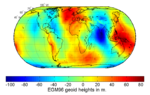
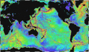
Geoid (category Geodesy)
years in the history of geodesy and geophysics, it has been defined to high precision only since advances in satellite geodesy in the late 20th century...
29 KB (3,435 words) - 15:33, 19 August 2024

Earth ellipsoid (category Geodesy)
approximating the Earth's form, used as a reference frame for computations in geodesy, astronomy, and the geosciences. Various different ellipsoids have been...
19 KB (2,379 words) - 03:42, 10 July 2024

InSight (redirect from Interior Exploration using Seismic Investigations, Geodesy and Heat Transport)
The Interior Exploration using Seismic Investigations, Geodesy and Heat Transport (InSight) mission was a robotic lander designed to study the deep interior...
140 KB (11,174 words) - 08:50, 27 August 2024
Geodesy, a short film produced and directed by Tathagata Mukherjee, was nominated for the Jio Filmfare Short Film Awards 2018. The film is about 'an interview'...
4 KB (242 words) - 17:09, 16 December 2023

variability (±10 km) for the following reasons. The International Union of Geodesy and Geophysics (IUGG) provides three reference values: the mean radius...
42 KB (4,364 words) - 00:23, 20 August 2024
The International Union of Geodesy and Geophysics (IUGG; French: Union géodésique et géophysique internationale, UGGI) is an international non-governmental...
13 KB (516 words) - 10:17, 27 May 2024
departments. As of 2022, it is structured into the Department of Aerospace & Geodesy, the Department of Architecture, the Department of Civil & Environmental...
30 KB (2,035 words) - 23:15, 2 September 2023
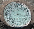
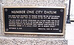
Survey marker (redirect from Geodesy marker)
Survey markers, also called survey marks, survey monuments, or geodetic marks, are objects placed to mark key survey points on the Earth's surface. They...
10 KB (1,244 words) - 18:30, 29 November 2023
Outline of metrology and measurement (section Geodesy)
geodesists History of geodesy Physical geodesy International Union of Geodesy and Geophysics International Association of Geodesy Unit of measurement System...
8 KB (486 words) - 10:13, 18 February 2024

geography can be divided into many broad categories, such as: Geodesign Geodesy Geoinformatics Geographic information science Geomatics Geovisualization...
93 KB (9,531 words) - 06:34, 12 August 2024
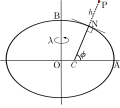
Geodetic coordinates (redirect from Ellipsoidal coordinates (geodesy))
coordinates are a type of curvilinear orthogonal coordinate system used in geodesy based on a reference ellipsoid. They include geodetic latitude (north/south)...
7 KB (893 words) - 13:52, 25 March 2024

The Federal Agency for Cartography and Geodesy (German: Bundesamt für Kartographie und Geodäsie, BKG) is Germany's national mapping agency. It is located...
2 KB (206 words) - 18:56, 1 August 2024
geodesist who conducted surveys in Germany and Africa and founded the German geodesy journal. Jordan was born in Ellwangen, a small town in southern Germany...
3 KB (308 words) - 23:03, 7 February 2024