
A geographic coordinate system (GCS) is a spherical or geodetic coordinate system for measuring and communicating positions directly on Earth as latitude...
22 KB (2,491 words) - 18:52, 1 October 2024
change of geographic coordinates, conversion of coordinate systems, or transformation to different geodetic datums. Geographic coordinate conversion...
34 KB (5,200 words) - 08:18, 10 August 2024

In mathematics, a spherical coordinate system is a coordinate system for three-dimensional space where the position of a given point in space is specified...
43 KB (6,352 words) - 05:39, 11 October 2024
The Swiss coordinate system (or Swiss grid) is a geographic coordinate system used in Switzerland and Liechtenstein for maps and surveying by the Swiss...
7 KB (968 words) - 17:51, 30 December 2023

A projected coordinate system – also called a projected coordinate reference system, planar coordinate system, or grid reference system – is a type of...
21 KB (2,803 words) - 22:28, 19 June 2024

the application of the abstract mathematics of coordinate systems and analytic geometry to geographic space. A particular SRS specification (for example...
15 KB (1,570 words) - 00:35, 6 September 2024
In geometry, a coordinate system is a system that uses one or more numbers, or coordinates, to uniquely determine the position of the points or other...
19 KB (2,285 words) - 06:01, 4 October 2024
The State Plane Coordinate System (SPCS) is a set of 125 geographic zones or coordinate systems designed for specific regions of the United States. Each...
7 KB (965 words) - 15:06, 26 February 2024

coordinates, projected on the celestial sphere, are analogous to the geographic coordinate system used on the surface of Earth. These differ in their choice of...
28 KB (3,978 words) - 14:53, 20 August 2024

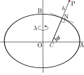
In geometry, the elliptic coordinate system is a two-dimensional orthogonal coordinate system in which the coordinate lines are confocal ellipses and...
9 KB (1,599 words) - 16:25, 17 November 2023

A planetary coordinate system (also referred to as planetographic, planetodetic, or planetocentric) is a generalization of the geographic, geodetic, and...
19 KB (2,166 words) - 18:52, 2 October 2024
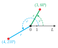
In mathematics, the polar coordinate system is a two-dimensional coordinate system in which each point on a plane is determined by a distance from a reference...
49 KB (6,687 words) - 17:08, 11 October 2024
different geographic regions, other datum systems can be used. Prior to the development of the Universal Transverse Mercator coordinate system, several...
17 KB (2,844 words) - 21:04, 2 October 2024

geographic coordinate system. In modern usage, graticules are contrasted with grids, which display the eastings and northings of another coordinate reference...
6 KB (713 words) - 01:03, 8 October 2024
related domains Coordinate space in mathematics Cartesian coordinate system Coordinate (vector space) Geographic coordinate system Coordinate structure in...
515 bytes (86 words) - 08:15, 21 February 2019

polar stereographic (UPS) coordinate system is used in conjunction with the universal transverse Mercator (UTM) coordinate system to locate positions on...
4 KB (499 words) - 18:09, 11 June 2024
Geodetic coordinates (redirect from Geodetic coordinate system)
Geodetic coordinates are a type of curvilinear orthogonal coordinate system used in geodesy based on a reference ellipsoid. They include geodetic latitude...
7 KB (893 words) - 13:52, 25 March 2024
from map-reading.com World Geographic Reference System (GEOREF), National Geospatial-Intelligence Agency Coordinate Systems Overview, from the University...
7 KB (897 words) - 18:56, 22 May 2023

often considered a subdiscipline of geography within the branch of technical geography. Geographic information systems are utilized in multiple technologies...
101 KB (13,118 words) - 02:43, 9 October 2024
converted to degrees for the WGS-84 input coordinates. BD-09 is a geographic coordinate system used by Baidu Maps, adding further obfuscation to GCJ-02 "to...
29 KB (2,999 words) - 18:33, 31 July 2024

Local tangent plane coordinates (redirect from Local geodetic coordinate system)
of rotation. They are also known as local ellipsoidal system, local geodetic coordinate system, local vertical, local horizontal coordinates (LVLH), or...
6 KB (729 words) - 05:16, 11 August 2024

are discussed at geographic coordinate conversion. As with any spatial reference system, ECEF consists of an abstract coordinate system (in this case, a...
9 KB (904 words) - 15:59, 18 September 2024
Geodetic datum (redirect from Geodetic Coordinate System)
of the shape of the earth, to the physical earth. Thus, the geographic coordinate system on that ellipsoid can be used to measure the latitude and longitude...
31 KB (3,346 words) - 06:28, 11 August 2024
Location (redirect from Geographic location)
a geographic entity (location or object) Geographical feature – Discrete phenomenon that exists at a location on Earth Geographic coordinate system –...
3 KB (453 words) - 16:04, 11 October 2024
National Grid (USNG), developed by the Federal Geographic Data Committee. World Geographic Reference System (GEOREF) has been used for air navigation, but...
15 KB (2,133 words) - 06:55, 13 February 2024

Latitude (redirect from Geographic latitude)
In geography, latitude is a coordinate that specifies the north–south position of a point on the surface of the Earth or another celestial body. Latitude...
47 KB (6,184 words) - 04:15, 21 September 2024
Fundamental plane (spherical coordinates) (category Geography)
the sphere. For a geographic coordinate system of the Earth, the fundamental plane is the Equator. Astronomical coordinate systems have varying fundamental...
2 KB (178 words) - 04:42, 4 October 2024
The Irish grid reference system is a system of geographic grid references used for paper mapping in Ireland (both Northern Ireland and the Republic of...
7 KB (753 words) - 17:04, 28 July 2024
Degree symbol (section Desktop operating systems)
used, among other things, to represent degrees of arc (e.g. in geographic coordinate systems), hours (in the medical field), degrees of temperature or alcohol...
17 KB (1,922 words) - 05:56, 30 July 2024

The tonal system is a base 16 system of notation (predating the widespread use of hexadecimal in computing), arithmetic, and metrology proposed in 1859...
5 KB (443 words) - 14:16, 30 June 2024