
Gooroolba is a rural locality in the North Burnett Region, Queensland, Australia. In the 2021 census, the locality of Gooroolba had a population of 21...
8 KB (578 words) - 22:42, 13 June 2024
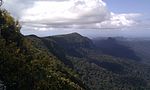
Rainbow Falls, Goomoolahra Falls, Kadjagooma Falls, Ngarri-dhum Falls, Gooroolba Falls, Poonyahra Falls, Poondahra Falls, and Blackfellow Falls. The Gwongorella...
16 KB (1,682 words) - 06:01, 16 June 2024
Boyd MLA and their wives came detached during shunting operations at the Gooroolba junction and rolled away, gathering speed down a streep grade. It hurtled...
29 KB (2,849 words) - 08:42, 22 May 2024
Archived from the original on 19 December 2017. Retrieved 16 March 2024. "GOOROOLBA". Maryborough Chronicle, Wide Bay And Burnett Advertiser. No. 13, 248...
10 KB (812 words) - 04:07, 31 May 2024

number of heritage-listed sites, including: Chowey Cemetery Road, off Gooroolba Biggenden Road: Chowey Cemetery (also known as Mount Shamrock Cemetery)...
11 KB (1,125 words) - 08:06, 25 May 2024
Suburbs around Ginoondan: Wetheron Byrnestown Gooroolba Wilson Valley Gayndah Ginoondan Coalstoun Lakes Campbell Creek Ban Ban Ban Ban...
3 KB (179 words) - 17:06, 25 July 2024
the locality. Mount Steadman Road enters the locality from the south (Gooroolba) and exits to the north (Mingo). The land use is grazing on native vegetation...
8 KB (676 words) - 06:04, 28 May 2024

151°50′E / 25.567°S 151.833°E / -25.567; 151.833 (Gooroolballin Parish) Gooroolba, Byrnestown Grongah Gympie 25°57′S 152°08′E / 25.950°S 152.133°E /...
5 KB (122 words) - 05:16, 27 September 2023

2040; 153.3024 (Hell Hole)) Gooroolba Falls (28°12′44″S 153°16′55″E / 28.2122°S 153.2819°E / -28.2122; 153.2819 (Gooroolba Falls)) Poonyahra Falls (28°12′49″S...
41 KB (4,634 words) - 00:43, 23 July 2024
(34.5 mi). This road intersects with Mount Steadman Road in Mingo and Gooroolba–Biggenden Road in Byrnestown. All distances are from Google Maps. Australian...
8 KB (684 words) - 17:06, 25 July 2024
D Yes Baralaba - Woorabinda Road 4632 D Yes Kalpowar Road 4702 D Yes Gooroolba - Biggenden Road 4706 D Yes Cania Dam Road 4715 D Yes Gympie - Woolooga...
39 KB (404 words) - 11:15, 8 May 2024

Eidsvold Wuruma Dam Gayndah area: Ban Ban Springs Binjour Byrnestown Gayndah Gooroolba Ideraway Wetheron Monto area: Bancroft Bukali Cannia Cannindah Coominglah...
17 KB (1,088 words) - 09:14, 21 June 2024
"Queensland Globe". State of Queensland. Retrieved 27 January 2024. "GOOROOLBA". Maryborough Chronicle, Wide Bay and Burnett Advertiser. No. 21, 845...
236 KB (6,864 words) - 08:34, 11 October 2024

the following settlements: Gayndah Ban Ban Springs Binjour Byrnestown Gooroolba Ideraway Wetheron Australian Bureau of Statistics (25 October 2007). "Gayndah...
6 KB (532 words) - 22:57, 15 November 2023
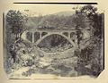
1907. The line passed through small sidings at Muan, Chowey, Didcot, Gooroolba and Byrnestown en route to Wetheron and at Mount Lawless, Dappil and Ideraway...
20 KB (1,842 words) - 02:28, 17 June 2024
Localities around Wetheron: Yenda Mingo Mount Steadman Mount Lawless Wetheron Gooroolba Bon Accord Gayndah Ginoondan Byrnestown...
14 KB (1,339 words) - 11:02, 22 June 2024

on 31 December 2007 before final closure on 5 June 2008. It was at 598 Gooroolba Road (25°28′58″S 151°59′50″E / 25.4829°S 151.9971°E / -25.4829; 151...
15 KB (1,218 words) - 04:18, 16 June 2024