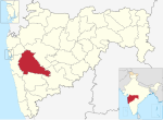
Indapur taluka is a taluka in Baramati subdivision of Pune district of state of Maharashtra in India. Indapur taluka has a population of 383,183 according...
4 KB (174 words) - 15:14, 13 March 2024
Khadakwasla canal system are major sources of irrigation and water supply for Indapur Taluka. Crops like wheat, sugarcane and jowar are grown here. The place also...
9 KB (962 words) - 14:40, 3 August 2024
Baramati Lok Sabha constituency. The constituency comprises Indapur taluka. The city of Indapur is located near Bheema river. "Delimitation of Parliamentary...
6 KB (110 words) - 12:03, 24 November 2024
Taluka. Baramati Taluka is bounded by Phaltan Taluka towards the South, Daund Taluka towards North, Indapur Taluka towards East and Purandhar Taluka towards...
6 KB (623 words) - 16:09, 12 October 2024
Minister of Solapur District. He is Member of Legislative Assembly (MLA) from Indapur Constituency. Warankar, Amol (22 April 2020). "दत्तात्रय भरणे आता सोलापूरचे...
4 KB (81 words) - 11:20, 24 August 2024
Pune district (section Talukas)
City taluka Pimpri-Chinchwad taluka Haveli taluka Mulshi taluka Velhe taluka Bhor taluka Purandar taluka Baramati taluka Daund taluka Indapur taluka Maval...
100 KB (10,378 words) - 15:51, 21 November 2024
Purandar taluka Velhe taluka Haveli taluka Pune City taluka Khed Taluka Ambegaon taluka Shirur taluka Junnar taluka Maval taluka Mulshi taluka The Table...
3 KB (110 words) - 07:59, 5 November 2024
Nira Narsingpur is a village in Indapur taluka of Pune district, Maharashtra, India. The confluence of rivers Bhima and Nira is behind the Shri Laxmi Narsimha...
3 KB (91 words) - 08:44, 24 May 2024
river and Nira river, at the south eastern tip of Pune district, in Indapur taluka. The temple is located at the ghat at confluence of Bhima river and...
4 KB (409 words) - 04:53, 11 November 2024
Indapur is a village located on the Mumbai-Goa Highway in India. Indapur comes under the Mangaon taluka of Raigad district. Talashet is the gram panchayat...
5 KB (375 words) - 09:17, 9 August 2024
Someshwarnagar. Shri Chhatrapati Co-operative Sugar Factory, in Bhavaninagar (Indapur). And The Malegaon Co-operative Sugar Factory in Malegaon. Apart from agriculture...
23 KB (2,157 words) - 05:49, 18 October 2024
River and Nira River, at the south eastern tip of Pune district, in Indapur taluka. Shri Narsimha of Nira Narsingpur is the family deity of many families...
11 KB (1,269 words) - 13:59, 23 November 2024
The table below lists all the talukas (tahsils/tehsils) of all the thirty-six districts in the Indian state of Maharashtra, along with district-subdivision...
23 KB (66 words) - 06:48, 18 November 2024
Laul is surrounded by Paranda Taluka towards North, Mohol Taluka towards East, Barshi Taluka towards East, Indapur Taluka towards west. Pandharpur, Kurduvadi...
9 KB (771 words) - 16:50, 7 November 2024
district which include Shirur, Purandar, Daund, Baramati and Indapur talukas as well as Phaltan taluka from neighboring Satara district in the proposed Baramati...
8 KB (545 words) - 16:15, 11 September 2024
is a small town and taluka in Mangaon subdivision of Raigad district of Maharashtra State in India. Tala is 15 km away from Indapur Town which is located...
3 KB (96 words) - 09:52, 30 July 2024
Umarga (Omerga) Tehsil is a tehsil/ taluka/ subdistrict in Osmanabad district, Maharashtra on the Deccan Plateau of India. The town of Umarga is the administrative...
10 KB (680 words) - 10:25, 10 May 2024
Khurd. 217 km from State capital Mumbai. "Map of Ghorpadwadi Village in Indapur Tehsil, Pune, Maharashtra". www.mapsofindia.com. Retrieved 27 March 2018...
840 bytes (67 words) - 06:36, 6 September 2021
/ 18.29944; 74.75444 Country India State Maharashtra District Pune Taluka Indapur Government • Body Village panchayat Languages • Official Marathi Time...
6 KB (489 words) - 21:07, 18 March 2024
shtra)-Jagdalpur(Chhattisgarh)-Kotpad(Odisha)-Borigumma 3. NH-65: Pune-Indapur-Solapur-Omerga-Hyderabad-Vijayawada-Machilipatnam(Andhra Pradesh) (Villages...
27 KB (2,196 words) - 18:29, 23 November 2024
Congress Junnar None Dhobale Dattatraya Amrutrao Indian National Congress Indapur None Patil Shankarrao Bajirao Indian National Congress Solapur District...
45 KB (203 words) - 21:22, 12 November 2024
At the beginning of March, Hari Makaji again rose, revolted and raided Indapur and raided, but was captured in Solapur in mid-March. Tatya Makaji led...
13 KB (1,160 words) - 01:16, 26 November 2024
Surat, Ahmednagar, Aurangabad, Khandesh, Nasik, Satana, Pune, Baramati, Indapur, Sangli, Satara, Solapur, Jalna, the Satara agency, and the southern Maratha...
16 KB (2,234 words) - 16:38, 23 November 2024
of Dharwad, Bijapur, North Kannada and Belgaum (excluding the Chandgad taluka) were transferred to Mysore state, while Abu Road taluk of the Banaskantha...
52 KB (213 words) - 07:58, 15 November 2024
Road Transport Corporation buses are available to reach the village. Pune-Indapur-Solapur-Omerga-Hyderabad-Vijayawada-Machilipatnam(Andhra Pradesh) National...
9 KB (563 words) - 13:14, 11 May 2023
Jambhali is a village in the Bhor taluka in the Pune District of Maharashtra, India. Jambhali has a total geographical area of village is 497.34 hectares...
3 KB (265 words) - 01:45, 17 June 2023
Bhira, Ville, Tise, Bhuvan, Talavali and Yeral. Nearby towns are Roha, Indapur, Mangaon and Nagothane. Kolad is located on NH 17, popularly known as the...
6 KB (443 words) - 05:48, 4 July 2024
epithet of "Raja". He was given deshmukhi rights of Pune, Supe, Chakan, and Indapur to provide for military expenses. He was also given Fort Shivneri for his...
115 KB (12,363 words) - 15:23, 23 November 2024
Mangdari is a village in Velhe Taluka in the Pune District of Maharashtra, India. Mangdari is located at 18°17′0″N 73°46′0″E / 18.28333°N 73.76667°E...
5 KB (387 words) - 01:46, 17 June 2023
Veer railway station located in Mahad taluka in Raigad is a station on Konkan Railway. It serves villages including Dasgaon, Veer, Vahoor,Tempale,Lonere...
2 KB (102 words) - 08:32, 30 July 2024


