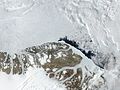
J.P. Koch Fjord is a fjord in Peary Land, northern Greenland. To the west, the fjord opens into the Lincoln Sea of the Arctic Ocean. It is named after...
3 KB (203 words) - 18:31, 1 September 2024

Greenland. It comprises six places in Nansen Land, on the east shore of J.P. Koch Fjord in the far north of Greenland. It was discovered in 1984 by A. Higgins...
16 KB (1,061 words) - 15:18, 17 March 2024

Navarana Fjord is located in the northeastern part of Freuchen Land, western Peary Land. It is the only significant branch of J.P. Koch Fjord, with the...
7 KB (599 words) - 11:00, 15 February 2024
the west by the Nordenskiöld Fjord and to the east by the J.P. Koch Fjord. Navarana Fjord, a branch of J.P. Koch Fjord, cuts deeply southwards into the...
4 KB (291 words) - 13:06, 31 March 2023

Odin Fjord Thor Fjord G.B. Schley Fjord Ormen Gardiner Fjord Hellefiske Fjord Hunt Fjord J.P. Koch Fjord Navarana Fjord Jewell Fjord Lemming Fjord Mascart...
8 KB (666 words) - 06:56, 8 March 2024
geologist William E. Davies called the wider range north of J.P. Koch Fjord and Frederick E. Hyde Fjord the "Nansen-Jensen Alps", with the westernmost foothills...
5 KB (462 words) - 14:34, 12 April 2024
the J.P. Koch Fjord. The Expedition Glacier discharges from the west north of the terminus of the Henson Glacier, between the head of the fjord and Navarana...
3 KB (234 words) - 11:59, 7 March 2024
in north Greenland, south east of John Murray Island, and west of J.P. Koch Fjord. The island is described as 'inconspicuous and fladt'. The island is...
5 KB (255 words) - 00:37, 22 July 2024
Peary Land (category Fjords of Greenland)
by smaller fjords, such as G.B. Schley Fjord and Hellefisk Fjord in the east, and Sands Fjord, Benedict Fjord, J.P. Koch Fjord, De Long Fjord and Weyprecht...
9 KB (1,006 words) - 00:27, 1 May 2024

J.P. Koch land is bounded by Upernavik Icefjord, in the west and south by Eqaluarssuit Fjord (sv). The land is about 1010 square-km in area. The J.P....
6 KB (519 words) - 05:45, 1 August 2024
National Park area. John Murray Island is located off the mouth of J.P. Koch Fjord in the Lincoln Sea, to the west of Sverdrup Island and to the north...
5 KB (113 words) - 00:45, 22 July 2024
west of Nansen Land, to the north of Freuchen Land off the mouth of J.P. Koch Fjord in the Lincoln Sea, and to the east of Elison Island and John Murray...
5 KB (167 words) - 02:33, 27 December 2023
of the De Long Fjord area, east of Freuchen Land across the inner J.P. Koch Fjord, west of Odin Fjord and south of the O.B. Bøggild Fjord. It is about 100 km...
4 KB (343 words) - 23:37, 22 July 2024
82°46′N 41°0′W / 82.767°N 41.000°W / 82.767; -41.000 (J.P. Koch Fjord) J.P. Koch Fjord 82°39′N 41°0′W / 82.650°N 41.000°W / 82.650; -41.000 (Greenland)...
4 KB (92 words) - 15:53, 16 September 2022
82°51′N 45°0′W / 82.850°N 45.000°W / 82.850; -45.000 (J.P. Koch Fjord) J.P. Koch Fjord 82°46′N 45°0′W / 82.767°N 45.000°W / 82.767; -45.000 (Greenland)...
5 KB (127 words) - 23:52, 15 June 2024
82°50′N 44°0′W / 82.833°N 44.000°W / 82.833; -44.000 (J.P. Koch Fjord) J.P. Koch Fjord 82°46′N 44°0′W / 82.767°N 44.000°W / 82.767; -44.000 (Greenland)...
4 KB (92 words) - 15:54, 16 September 2022
42°0′W / 82.850°N 42.000°W / 82.850; -42.000 (J.P. Koch Fjord) J.P. Koch Fjord / Navarana Fjord 82°40′N 42°0′W / 82.667°N 42.000°W / 82.667; -42...
3 KB (92 words) - 15:54, 16 September 2022
(Greenland) Greenland Nansen Land J.P. Koch Fjord — 82°51′N 43°0′W / 82.850°N 43.000°W / 82.850; -43.000 (J.P. Koch Fjord) Freuchen Land — 82°30′N 43°0′W...
3 KB (92 words) - 15:54, 16 September 2022

that the glacier tongue extended into Lake Alida (near Foulk Fjord). In 1938, Lauge Koch found in the mountains west of Jameson Land, near Scoresby Sound...
11 KB (1,096 words) - 22:32, 16 July 2024

Cape and Navy Cliff — at the head of Independence Fjord. Meanwhile the other team — with Johan Peter Koch, Aage Bertelsen and Tobias Gabrielsen — sped northwestwards...
14 KB (1,904 words) - 19:15, 18 March 2024

side of the broad valley known as Sirius Passet at its junction with J.P. Koch Fjord 82°47′6″N 42°13′7″W / 82.78500°N 42.21861°W / 82.78500; -42.21861...
7 KB (859 words) - 06:04, 23 November 2023

Davies called the long mountain system to the north of J.P. Koch Fjord and Frederick E. Hyde Fjord the "Nansen-Jensen Alps", with the westernmost foothills...
4 KB (282 words) - 23:52, 12 July 2024

and eventually fell into the waters of the Borg Fjord during a calving event. One year after J.P. Koch's death Wegener would return to Greenland for the...
14 KB (2,000 words) - 17:08, 15 January 2024

by J.P. Koch. Koch named the island after Johannes Lindhard (1870–1947), the doctor on the 1906–1908 Danmark Expedition. The narrow Kavaler Fjord 76°32′N...
6 KB (398 words) - 00:45, 22 July 2024
by Knud Rasmussen and Lauge Koch from the top of Thule Mountain which rises in Hazenland above the shore of De Long Fjord. Rasmussen named it after Danish...
3 KB (275 words) - 17:20, 1 September 2024

Fjord and Frederick E. Hyde Fjord are two great fjords of the far-northeast Greenland coast having their mouths in the Wandel Sea. G.B. Schley Fjord and...
3 KB (271 words) - 18:50, 3 September 2023

Expedition and the 1912–13 Danish Expedition to Queen Louise Land led by J.P. Koch. Wegener died in 1930 on the Greenland ice sheet during the Wegener Expedition...
3 KB (194 words) - 23:54, 15 June 2024

by Lauge Koch in the 1920s. In 1953 a geological expedition crossed the range through the Polkorridoren pass from Frigg Fjord to Sands Fjord. The highest...
8 KB (849 words) - 23:42, 12 July 2024

side of the broad valley known as Sirius Passet at its junction with J. P. Koch Fjord. Aaveqaspis inesoni was probably a marine bottom dweller, that lived...
6 KB (687 words) - 17:25, 27 March 2024
mouth. The inner fjord branches were mapped and named by Lauge Koch in the course of aerial surveys from the 1920s onwards. Odin Fjord is an offshoot on...
2 KB (218 words) - 05:02, 21 June 2024