National Route 56 is a national highway of Japan connecting Kōchi and Matsuyama. Route 56 was designated on 18 May 1953 on the current route as National...
2 KB (101 words) - 03:07, 9 August 2024
National Route 11 (国道11号, Kokudō Jūichi-gō) is a Japanese highway on the island of Shikoku. The most important artery in Shikoku, it originates at the...
4 KB (265 words) - 03:05, 9 August 2024
National Route 1 (国道1号, Kokudō Ichi-gō) is a major highway on the island of Honshū in Japan. It connects Chūō, Tokyo in the Kantō region with the city...
66 KB (842 words) - 03:05, 9 August 2024

length of 260 km (161.56 mi). "一般国道の路線別、都道府県別道路現況" [Road statistics by General National Highway route and prefecture] (PDF) (in Japanese). Ministry of Land...
1 KB (71 words) - 03:13, 9 August 2024
Highway 56 (India) Road 56 Autostrada A56 Japan National Route 56 National Route 56 Gukjido 56 New Zealand State Highway 56 N56 highway (Philippines)...
6 KB (414 words) - 16:07, 27 August 2024
National Route 359 is a national highway of Japan connecting Toyama, Toyama and Kanazawa, Ishikawa in Japan, with a total length of 56.2 km (34.92 mi)...
1 KB (72 words) - 03:17, 9 August 2024

National Route 197 (国道197号, Kokudō Hyaku-kyūjū-nana-gō) is a Japanese national highway running on the islands of Kyūshū and Shikoku. The 223.1-kilometer-long...
3 KB (287 words) - 02:55, 1 July 2024

National Route 204 is a national highway of Japan connecting Karatsu and Sasebo in Japan, with a total length of 157 km (97.56 mi). "一般国道の路線別、都道府県別道路現況"...
1 KB (69 words) - 03:12, 9 August 2024
National Route 33 (国道33号, Kokudō Sanjūsan-gō), also known as the Tosa Kaidō, is a Japanese highway on the island of Shikoku. It originates at the intersection...
3 KB (211 words) - 03:06, 9 August 2024
National Route 498 is a national highway of Japan connecting between Kashima, Saga and Sasebo, Nagasaki in Japan, with total length has 56.6 km (35.2 mi)...
1 KB (72 words) - 03:11, 9 August 2024
length of 155.4 km (96.56 mi). "一般国道の路線別、都道府県別道路現況" [Road statistics by General National Highway route and prefecture] (PDF) (in Japanese). Ministry of Land...
1 KB (77 words) - 21:40, 20 March 2024

length of 52.4 km (32.56 mi). "一般国道の路線別、都道府県別道路現況" [Road statistics by General National Highway route and prefecture] (PDF) (in Japanese). Ministry of Land...
1 KB (72 words) - 03:14, 9 August 2024
National Route 57 (国道57号, Kokudō Gojūnana-gō) is a national highway of Japan connecting Ōita and Nagasaki in Japan. Length: 326.7 km (203.0 mi) Origin:...
6 KB (440 words) - 02:46, 18 March 2024

National Route 356 is a national highway of Japan connecting Chōshi, Chiba and Abiko, Chiba in Japan, with a total length of 91.7 km (56.98 mi). "一般国道の路線別、都道府県別道路現況"...
1 KB (72 words) - 03:17, 9 August 2024

of 173.1 km (107.56 mi). "一般国道の路線別、都道府県別道路現況" [Road statistics by General National Highway route and prefecture] (PDF) (in Japanese). Ministry of Land...
1 KB (72 words) - 03:14, 9 August 2024

length has 68.5 km (42.56 mi). "一般国道の路線別、都道府県別道路現況" [Road statistics by General National Highway route and prefecture] (PDF) (in Japanese). Ministry of Land...
1 KB (64 words) - 03:10, 9 August 2024

Japan has a nationwide system of national highways (一般国道, Ippan Kokudō) distinct from the expressways. The Ministry of Land, Infrastructure, Transport...
18 KB (727 words) - 03:05, 9 August 2024
National Route 384 is a national highway of Japan on the islands of Fukue and Nakadōri, Nagasaki Prefecture with a total length of 91.7 km (56.98 mi)....
1 KB (83 words) - 21:37, 20 March 2024

National Route 200 (国道200号, Kokudō Nihyaku-gō) is a national highway of Japan connecting Yahatanishi-ku, Kitakyūshū and Chikushino, Fukuoka, with a total...
2 KB (136 words) - 03:12, 9 August 2024
National Route 4 (国道4号, Kokudō Yongō) is a major national highway in eastern Honshū, Japan. Measuring 738.5 kilometers long (458.9 mi), it is the longest...
70 KB (1,021 words) - 03:05, 9 August 2024

But War: the United States Embargo Against Japan and the Eruption of War in the Pacific. McFarland. pp. 56, 86. ISBN 978-0-7864-0141-3. Bailey, Beth;...
201 KB (16,460 words) - 18:39, 8 September 2024
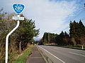
National Route 280 (国道280号, Kokudō Nihyaku hachi-jugō) is a national highway of Japan that traverses the prefectures, Aomori and Hokkaido as well as the...
11 KB (708 words) - 08:53, 8 May 2024
National Route 410 (国道410号, Kokudō Yonhyakujūgō) is a national highway located entirely within Chiba Prefecture, Japan. It connects the cities of Tateyama...
15 KB (511 words) - 03:10, 9 August 2024
National Route 454 (国道454号, Kokudō Yonhyaku go-juyongō) is a national highway of Japan that traverses southern Aomori Prefecture and briefly crosses into...
8 KB (394 words) - 03:20, 9 August 2024

National Route 7 (国道7号, Kokudō Nanagō) is a major north-south national highway on the Sea of Japan side of the island of Honshū, Japan. It traverses four...
35 KB (473 words) - 03:05, 9 August 2024
National Route 55 (国道55号, Kokudō Gojūgogō) is a national highway of Japan connecting the capitals of Tokushima and Kōchi prefectures, Tokushima and Kōchi...
5 KB (402 words) - 03:06, 9 August 2024
National Route 12 (国道12号, Kokudō Jūni-gō) is a Japanese national highway connecting the two largest cities of Hokkaido, Sapporo and Asahikawa. The 135...
20 KB (921 words) - 03:05, 9 August 2024

National Route 196 is a national highway of Japan connecting Matsuyama and Saijō, Ehime in Japan, with a total length of 66.4 km (41.26 mi). "一般国道の路線別、都道府県別道路現況"...
1 KB (71 words) - 03:12, 9 August 2024

Fudai, Iwate (category Populated coastal places in Japan)
Horinai Sanriku-kita Jūkan Road National Route 45 Rikuchū-Kurosaki Light – one of the "50 Noteworthy Lighthouses of Japan" Fudai village official statistics...
16 KB (951 words) - 17:55, 3 August 2024

National Route 279 (国道279号, Kokudō Nihyaku nana-jukyūgō) is a national highway of Japan that traverses the prefectures of Aomori and Hokkaido, as well...
21 KB (1,744 words) - 14:30, 26 August 2024