
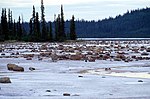
The Kakisa River is a major tributary of the Mackenzie River in the Northwest Territories of Canada. The river gives the name to the Kakisa Formation...
3 KB (228 words) - 19:45, 31 January 2024
Kakisa[pronunciation?] (Slavey language: K’agee[pronunciation?]; between the willows) is a "Designated Authority" in the South Slave Region of the Northwest...
10 KB (561 words) - 04:40, 14 April 2022
Mackenzie River (French: Fleuve (de) Mackenzie; Slavey: Deh-Cho [tèh tʃʰò], literally big river; Inuvialuktun: Kuukpak [kuːkpɑk], literally great river) is...
72 KB (6,655 words) - 05:37, 3 September 2024
Cameron River Taltson River Lockhart River Kakisa River (Alberta) Horn River Bouvier River Redknife River Trout River Jean Marie River Spence River Rabbitskin...
6 KB (376 words) - 05:22, 13 July 2022

Great Bear Lake (redirect from Dease River (Great Bear Lake))
Whitefish River, Big Spruce River, Haldane River, Bloody River, Sloan River, Dease River and the Johnny Hoe River. Great Bear Lake lies between two major...
14 KB (1,395 words) - 04:24, 3 September 2024

Mountains Natural Region. The centrepiece of the park is the South Nahanni River (Naha Dehé). Four noteworthy canyons reaching 1,000 m (3,300 ft) in depth...
30 KB (3,590 words) - 12:55, 24 September 2024

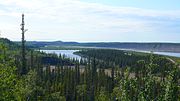
Kakisa Lake is a large lake located in the Northwest Territories, Canada. It is fed by the Kakisa River, and near to the community of Kakisa. An outcropping...
1 KB (59 words) - 22:05, 25 September 2023
Territories, Canada. The community is situated at the mouth of the Slave River, on the shores of Great Slave Lake, and at the end of the Fort Resolution...
18 KB (1,283 words) - 16:55, 16 August 2024
The Kakisa Formation is a stratigraphical unit of Frasnian age in the Western Canadian Sedimentary Basin. It takes the name from the Kakisa River, a tributary...
3 KB (244 words) - 20:19, 13 August 2023
He later was a gold-rusher and then moved back to Manitoba. Kakisa River. Kakwa River. Kananaskis Kapasiwin: Cree for 'campsite' Kapawe'no First Nation...
91 KB (10,413 words) - 21:35, 31 August 2024
and completed to Hay River, Northwest Territories, in 1948/1949, but some sections, particularly in the vicinity of Steen River, remained difficult. In...
12 KB (666 words) - 05:40, 27 August 2024
Wood Buffalo National Park (redirect from Jackfish River, Alberta)
The park ranges in elevation from 183 m (600 ft) at the Little Buffalo River to 945 m (3,100 ft) in the Caribou Mountains. The park headquarters is in...
26 KB (2,727 words) - 20:34, 26 August 2024
R.W. and Huffaker, M.F. Island Falls Power Development on the Churchill River, a paper presented at the annual general meeting of the Canadian Institute...
63 KB (1,659 words) - 11:03, 1 May 2024

Back during the Arctic Land Expedition to the Arctic Ocean via the Back River. The expedition, partly scientific and partly searching for the missing...
11 KB (683 words) - 00:06, 24 July 2024

River Crossing Chan Lake Dory Point Fort Providence Fort Simpson Fort Smith Mission Fred Henne Happy Valley Hay River Hidden Lake Ja'k Kakisa River Lady...
9 KB (948 words) - 17:00, 6 April 2024

River Territorial Park McKinnon Territorial Park 60th Parallel Territorial Park Fort Smith Mission Territorial Park Hay River Territorial Park Kakisa...
3 KB (228 words) - 05:22, 13 July 2022

in the Northwest Territories and encompassing areas of the South Nahanni River watershed. The name means "stands like a porcupine" in the Dene language...
13 KB (1,276 words) - 06:01, 3 September 2024

Northwest Territories, Canada. It is located on the east bank of the Peel River and is 121 km (75 mi) south of Inuvik on the Dempster Highway. The First...
29 KB (1,436 words) - 21:35, 31 August 2024
River Crossing Chan Lake Dory Point Fort Providence Fort Simpson Fort Smith Mission Fred Henne Happy Valley Hay River Hidden Lake Ja'k Kakisa River Lady...
9 KB (870 words) - 19:04, 23 February 2024

Canada. It is known for its access to the Thomsen River, one of the most northerly navigable rivers in North America. The park is a fly-in park, and protects...
9 KB (807 words) - 23:16, 29 July 2024

River Crossing Chan Lake Dory Point Fort Providence Fort Simpson Fort Smith Mission Fred Henne Happy Valley Hay River Hidden Lake Ja'k Kakisa River Lady...
10 KB (683 words) - 04:38, 8 August 2024

Enterprise Fort Providence Fort Resolution Fort Smith Hay River Reserve Hay River Kakisa The South Slave Region is one of five administrative regions in...
9 KB (277 words) - 16:11, 15 September 2024

River Crossing Chan Lake Dory Point Fort Providence Fort Simpson Fort Smith Mission Fred Henne Happy Valley Hay River Hidden Lake Ja'k Kakisa River Lady...
2 KB (121 words) - 07:41, 7 November 2022

Fort Simpson (category Populated places on the Mackenzie River)
Simpson (Slavey language: Łı́ı́dlı̨ı̨ Kų́ę́[pronunciation?] "place where rivers come together") is a village, the only one in the entire territory, in the...
38 KB (1,863 words) - 02:51, 22 July 2024

Roman Catholic church building located on a bluff overlooking the Mackenzie River in Fort Good Hope, Northwest Territories, Canada. Only 45 by 25 feet (13...
7 KB (211 words) - 19:26, 4 July 2023

Northwest Territories. The main rivers that run through the park are the Hornaday River, Brock River and Roscoe River. Humans have occupied Tuktut Nogait...
9 KB (849 words) - 11:06, 18 May 2024

surrounding area in Mackenzie Bay at the northern tip of the Mackenzie River Delta. A seasonal sanctuary for more than 60,000 shorebirds, it is one of...
8 KB (661 words) - 05:02, 3 September 2024

River Crossing Chan Lake Dory Point Fort Providence Fort Simpson Fort Smith Mission Fred Henne Happy Valley Hay River Hidden Lake Ja'k Kakisa River Lady...
4 KB (361 words) - 10:07, 21 July 2024

between the Baillie River on the west and the Consul River at the east by the Back River. It is the namesake of the Thelon River, whose river valley is resplendent...
7 KB (619 words) - 06:28, 6 July 2024

River Crossing Chan Lake Dory Point Fort Providence Fort Simpson Fort Smith Mission Fred Henne Happy Valley Hay River Hidden Lake Ja'k Kakisa River Lady...
12 KB (1,070 words) - 00:23, 16 September 2024