
Kentucky Route 97 (KY 97) is a 18.262-mile-long (29.390 km) state highway in Graves County, Kentucky that runs from Tennessee State Route 69 (SR 69) and...
5 KB (317 words) - 17:54, 16 February 2024
State Route 97 Idaho State Highway 97 Illinois Route 97 Illinois Route 97A (former) Iowa Highway 97 (former) Kentucky Route 97 Louisiana Highway 97 Maine...
4 KB (347 words) - 16:21, 27 August 2024

have portions within the State Primary and State Secondary systems. Kentucky Route 301 is a 6.210-mile-long (9.994 km) rural secondary highway in eastern...
95 KB (9,567 words) - 02:37, 9 July 2024
Illinois to U.S. Route 25 in Mount Vernon, Kentucky. In the state of Illinois, U.S. 150 runs from the Quad City International Airport at U.S. Route 6 southeast...
31 KB (997 words) - 05:11, 21 October 2023

U.S. Route 31E (US 31E) is the eastern parallel route for U.S. Highway 31 from Nashville, Tennessee, to Louisville, Kentucky. US 31E begins as the Ellington...
33 KB (1,340 words) - 10:11, 1 September 2024

route of Kentucky Route 121. It runs from Kentucky Route 121, Kentucky Route 80, and Kentucky Route 97 southeast of Mayfield to Kentucky Route 121 and...
10 KB (163 words) - 21:30, 13 January 2024

Kentucky Route 80 (KY 80) is a 483.55-mile-long (778.20 km) state highway in the southern part of the U.S. state of Kentucky. The route originates on...
64 KB (1,742 words) - 04:20, 25 July 2024

Kentucky Route 15 begins at a junction of US 119/Corridor F & Business KY 15 in Whitesburg, and terminates in Winchester at US 60. It is a major route...
20 KB (556 words) - 23:56, 8 April 2023

U.S. Route 68 (US 68) is a United States highway that runs for 560 miles (900 km) from northwest Ohio to Western Kentucky. The highway's western terminus...
71 KB (1,848 words) - 21:59, 31 August 2024
U.S. Route 641 (US 641) is a U.S. Route in Tennessee and Kentucky. It runs for 165.45 miles (266.27 km) from US 64 south of Clifton, Tennessee to an intersection...
21 KB (853 words) - 14:16, 18 February 2024

have portions within the State Primary and State Secondary systems. Kentucky Route 2502 is a 0.201-mile-long (0.323 km) supplemental road in Carlisle in...
41 KB (4,089 words) - 21:34, 16 August 2024

in Kentucky to Interstate 64 at Charleston, West Virginia. In Kentucky, US 119 is a two- and four-lane highway running from Pineville at U.S. Route 25E...
55 KB (2,217 words) - 16:55, 3 June 2024
U.S. Route 421 (US 421) in the U.S. state of Kentucky is a 250.536-mile-long (403.199 km) north–south United States highway that traverses twelve counties...
31 KB (678 words) - 23:04, 8 March 2024

U.S. Route 42 (US 42) is an east–west United States highway that runs southwest–northeast for 350 miles (560 km) from Louisville, Kentucky to Cleveland...
51 KB (2,236 words) - 16:34, 31 August 2024

Kentucky Route 7 (KY 7) is a 203.073-mile-long (326.814 km) state highway in the U.S. state of Kentucky. Kentucky Route 7 begins at a junction with KY...
18 KB (281 words) - 00:12, 31 March 2024

U.S. Route 23 (US 23) is a 157.765-mile-long (253.898 km) United States Numbered Highway in the state of Kentucky. It travels from the Virginia state line...
20 KB (380 words) - 23:06, 8 March 2024
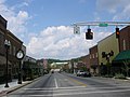
London is a home rule-class city in Laurel County, Kentucky, in the United States. It is the seat of its county. The population was 8,053 at the time of...
21 KB (1,514 words) - 02:34, 20 September 2024

Kentucky Route 79 (KY 79) is a 102-mile-long (164 km) north–south state highway that traverses five counties in west-central Kentucky. It can be seen...
16 KB (910 words) - 23:09, 10 February 2024

Kentucky Route 55 (KY 55) is a 140.858-mile-long (226.689 km) state highway in the U.S. Commonwealth of Kentucky. The route originates at a junction with...
26 KB (1,411 words) - 19:03, 26 October 2023

valley of the North Fork of the Kentucky River, five miles (8 km) west of the border of Kentucky and Virginia. Kentucky Route 15 passes through the city,...
18 KB (1,604 words) - 04:00, 21 September 2024

seat of Nicholas County. It is located at the junction of Kentucky Route 32 and Kentucky Route 36, about halfway between Lexington and Maysville. Carlisle...
9 KB (637 words) - 20:32, 15 July 2023
Kentucky are maintained by the Kentucky Transportation Cabinet, which classifies routes as either primary or secondary. Some routes, such as Kentucky...
31 KB (125 words) - 01:23, 22 September 2024
Interstate 265 (redirect from Kentucky Route 841)
terminate at the I-64 interchange. The entire Kentucky stretch of the road is cosigned with Kentucky Route 841 (KY 841). An additional 10.25-mile-long (16...
19 KB (1,322 words) - 01:30, 27 September 2024

that runs 887.30 miles (1,427.97 km) north–south from Mobile, Alabama, to Gary, Indiana. The highway crosses Kentucky from south to north, from the Tennessee...
30 KB (1,924 words) - 06:09, 9 October 2024

U.S. Route 27 (US 27) in Kentucky runs 201.120 miles (323.671 km) from the Tennessee border to the Ohio border at Cincinnati. It crosses into the state...
29 KB (438 words) - 01:41, 5 August 2024

It is located along the Licking River at the junction of Kentucky Route 7 and U.S. Route 460. By 1816, an early settlement at the town site was called...
15 KB (1,439 words) - 07:56, 28 June 2024

Cincinnati/Northern Kentucky International Airport (IATA: CVG, ICAO: KCVG, FAA LID: CVG) is a public international airport located in Boone County, Kentucky, United...
70 KB (4,765 words) - 02:12, 12 October 2024

along U.S. Route 68 / Kentucky Route 80, about 10 miles (16 km) east of Hopkinsville and 9 miles (14 km) west of Elkton. The original route of U.S. 68...
10 KB (655 words) - 03:16, 3 October 2024

where Route 52 split to the northwest. Route 62 began at Ashland, Kentucky (near Huntington) and followed the Midland Trail across northeastern Kentucky to...
50 KB (5,489 words) - 08:06, 21 September 2024

Pan-American Highway (redirect from Pan-American Highway (route))
Columbia Highway 97 and Highway 2 to Alberta both pick up where the southern end of the Alaska highway leaves off. Highway 97 becomes U.S. Route 97 at the Canada–US...
71 KB (8,734 words) - 10:49, 26 September 2024