Kerewan is a town in the Gambia. Located beside the Miniminiyang Bolong, about 60 km from the capital Banjul. It is the seat of the Kerewan Local Government...
6 KB (128 words) - 07:18, 5 May 2023

Gimara Bakadaji Gunjur Janjanbureh (Georgetown) Jufureh Kalagi Kanilai Kerewan Kololi Kotu Kuntaur Lamin (North Bank Division) Lamin (Western Division)...
2 KB (89 words) - 22:06, 20 April 2024
Bantango Koto (redirect from Old Kerewan)
Bantango Koto is a village in the Gambia. It is located in Wuli District in the Upper River Division. As of 2009, it has an estimated population of 327...
5 KB (66 words) - 04:24, 7 August 2022
Lower River) 1,628.0 72,167 82,381 Mansakonko 6 Kerewan (formerly North Bank) 2,255.5 172,835 221,054 Kerewan 7 Kuntaur (formerly the western half of Central...
117 KB (10,552 words) - 02:46, 30 August 2024
government areas. They are: Banjul Basse Brikama Janjanbureh Kanifing Kerewan Kuntaur Mansakonko Divisions of the Gambia List of local government areas...
613 bytes (38 words) - 23:55, 23 December 2022

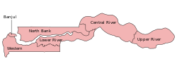
Districts of the Gambia (section Kerewan LGA)
The Gambia is subdivided into 43 districts. They are listed below by Local Government Area (previously Regions, known as Divisions until 2007), each with...
4 KB (344 words) - 03:12, 15 July 2024

opposite Farafenni Gamtel, and nearby there are shops and a small market on Kerewan Highway. Both markets serve the needs of the inhabitants. There is also...
7 KB (281 words) - 05:10, 20 June 2024
78.09 Lower River Mansa Konko Region 82,361 1,618.00 50.90 North Bank Kerewan Region 221,054 2,255.50 98.01 Upper River Basse Region 239,916 2,069.50...
10 KB (923 words) - 03:06, 15 July 2024

RFO TV) SECAM Gabon 1973 RTG SECAM Gambia 1973/1976/1979 GTN, GRTS, Kerewan TV SECAM Color broadcasts from Guinea have been available since 1971. Test...
99 KB (3,022 words) - 07:43, 27 August 2024

administrative divisions of the Gambia. Its capital was Kerewan. It was subsequently reorganised as the Kerewan Local Government Area (LGA), without any change...
11 KB (946 words) - 15:26, 3 December 2021

3 4.2 Kanifing 3.3 5.7 4.5 Brikama 4.1 6.9 5.7 Mansakonko 5.4 9.7 7.1 Kerewan 5.4 8.2 6.9 Kuntaur 6.4 11.9 7.2 Janjanbureh 5.7 8.7 7.0 Basse 5.7 9.6...
30 KB (1,406 words) - 08:00, 21 May 2024
448 5XXX Kaiaf 554 0XXX Kanilia 448 XXXX Kartong 4419XXX Kaur 574 8XXX Kerewan 572 0XXX Kotu 446 XXXX Kudang 554 6XXX Kuntaur 566 5XXX Kwenella 554 1XXX...
3 KB (48 words) - 13:13, 26 February 2024
institution where she learned about her Islam religion. She proceed to Kerewan Primary School up to primary 2. After completion of Primary two, Salimatou...
5 KB (488 words) - 07:47, 27 September 2023
launched The Gambia Classes for Open Learning Programme (GCOL) in the town of Kerewan. In August 2023, The Luminos Fund was announced as a finalist for the 2023...
9 KB (791 words) - 10:34, 1 June 2024

Assumed office 2009 Preceded by Party established Personal details Born Kerewan Political party Gambia Moral Congress Other political affiliations Coalition...
3 KB (147 words) - 17:39, 21 April 2023
Kanifing The National People's Party won all but one rural elections. Kerewan Kuntaur Janjangbureh Lower River Region (Mansakonko) The United Democratic...
5 KB (195 words) - 06:48, 4 June 2023
Gambia. Its main town was Farafenni. The North Bank Division is now the Kerewan Local Government Area, and the former Upper Baddibu District is now divided...
5 KB (97 words) - 17:18, 23 June 2022
development 2 Banjul 0.546 3 Brikama 0.530 – Gambia (average) 0.500 4 Kerewan 0.450 5 Mansakonko 0.443 6 Basse 0.426 7 Janjanbureh 0.390 8 Kuntaur 0...
2 KB (39 words) - 04:45, 2 March 2023
(habitat/species management area) Location North Bank Division Gambia Nearest city Kerewan Coordinates 13°28′26″N 16°4′36″W / 13.47389°N 16.07667°W / 13.47389;...
1 KB (87 words) - 07:25, 24 December 2020
service branches are also in Serrekunda, Bakau, Brikama, Soma, Farafenni, Kerewan, Kaur, Janganbureh, Basse, Wassu, Brusubi, Bwiam and at the Banjul International...
1 KB (122 words) - 12:22, 27 September 2023