
eventually renamed to Landsat 1 in 1975. The most recent, Landsat 9, was launched on 27 September 2021. The instruments on the Landsat satellites have acquired...
41 KB (3,817 words) - 05:15, 6 September 2024
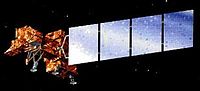
Landsat 7 is the seventh satellite of the Landsat program. Launched on 15 April 1999, Landsat 7's primary goal is to refresh the global archive of satellite...
14 KB (1,369 words) - 03:01, 26 August 2024

Landsat 8 is an American Earth observation satellite launched on 11 February 2013. It is the eighth satellite in the Landsat program; the seventh to reach...
23 KB (2,255 words) - 19:27, 15 May 2024

Landsat 9 is an Earth observation satellite launched on 27 September 2021 from Space Launch Complex-3E at Vandenberg Space Force Base on an Atlas V 401...
10 KB (859 words) - 11:31, 24 September 2024
Landsat 6, equipped with upgraded versions of the instruments on Landsat 5, was designed to carry forward the Landsat program. It was launched on October...
5 KB (368 words) - 23:34, 25 April 2024

Landsat 4 is the fourth satellite of the Landsat program. It was launched on July 16, 1982, with the primary goal of providing a global archive of satellite...
12 KB (1,237 words) - 15:57, 3 October 2024
Landsat 5 was a low Earth orbit satellite launched on March 1, 1984, to collect imagery of the surface of Earth. A continuation of the Landsat Program...
11 KB (1,119 words) - 23:11, 22 July 2024

Landsat 1 (LS-1), formerly named ERTS-A and ERTS-1, was the first satellite of the United States' Landsat program. It was a modified version of the Nimbus...
12 KB (1,139 words) - 12:58, 9 April 2024

Landsat 3 is the third satellite of the Landsat program. It was launched on March 5, 1978, with the primary goal of providing a global archive of satellite...
12 KB (1,291 words) - 13:10, 19 November 2023

Satellite imagery (section Landsat)
media and among the public. Also in 1972 the United States started the Landsat program, the largest program for acquisition of imagery of Earth from space...
31 KB (3,471 words) - 04:17, 22 August 2024

Landsat 2 is the second satellite of the Landsat program. The spacecraft originally carried a designation of ERTS-B (Earth Resource Technology Satellite...
11 KB (1,213 words) - 23:21, 25 April 2024

Landsat Island is a small, uninhabited island located at approximately 60°10'37"N 64°02'30"W, 20 kilometres (12 mi) off the northeast coast of Labrador...
3 KB (400 words) - 03:54, 13 April 2023
November 2004, operational Landsat program Landsat 1, launched July 1972, completed Landsat 2, launched January 1975, completed Landsat 3, launched March 1978...
48 KB (3,953 words) - 18:17, 29 September 2024
List of Atlas launches (2020–2029) (section Landsat 9)
archive. It is the ninth satellite developed in the Landsat program, and eighth to reach orbit (Landsat 6 failed to reach orbit). The Critical Design Review...
38 KB (2,179 words) - 04:54, 4 October 2024

to the Landsat program, having designed the Multispectral Scanner which was first used on Landsat 1. She has been called "The Mother of Landsat" for this...
12 KB (1,028 words) - 13:15, 17 September 2024

renamed to Landsat 1 in 1975. The most recent satellite in the series, Landsat 9, was launched on September 27, 2021. The instruments on the Landsat satellites...
224 KB (20,754 words) - 10:58, 28 September 2024

remote sensing instrument aboard Landsat 8, built by Ball Aerospace & Technologies. Landsat 8 is the successor to Landsat 7 and was launched on February...
6 KB (608 words) - 18:24, 17 May 2024

This land cover map of Nepal using Landsat 30 m (2010) data shows forest cover as the dominant type of land cover in Nepal....
270 KB (24,094 words) - 07:15, 30 September 2024

Badwater', a lake only noted after heavy winter and spring rainfall, Badwater Basin, Death Valley National Park, 9 February 2005. Landsat 5 satellite photo...
81 KB (9,645 words) - 12:03, 1 September 2024

formats that image processing systems used in the early years of NASA's Landsat program. Thomas was born in Baltimore, Maryland. She graduated from high...
11 KB (1,032 words) - 17:30, 17 May 2024
Before the launch of NASA and the USGS's Landsat 8 satellite, Google relied partially on imagery from Landsat 7, which suffered from a hardware malfunction...
94 KB (8,564 words) - 21:56, 30 September 2024
requests was first demonstrated at large scale when AWS started hosting Landsat data on Amazon S3 in 2015. The pattern was developed into the COG within...
7 KB (748 words) - 23:40, 7 May 2024

Generation imagery Landsat 7 imagery NLT Landsat (Visible & Pseudo Color) Geocover 1990 & 2000 (pseudo; 1990 layer was produced from Landsat 4 & 5 images)...
20 KB (1,994 words) - 19:35, 15 September 2024

Landsat 8 image of Tampa Bay Region...
190 KB (18,098 words) - 10:37, 19 September 2024

appears green in the image, a red apple red, a blue sky blue, and so on. Two Landsat satellite images showing the same region: Chesapeake Bay and the city of...
27 KB (2,239 words) - 09:37, 31 March 2024
International (SI), the most widely used metric system METRIC, a model that uses Landsat satellite data to compute and map evapotranspiration (ET) in climatology/meteorology...
2 KB (339 words) - 16:46, 6 March 2024

Absheron Peninsula satellite image, Landsat 5, 6 September 2010...
116 KB (10,333 words) - 11:25, 27 September 2024

Satellite image of Santiago taken by Landsat 8 on 24 October 2014....
149 KB (14,480 words) - 20:16, 21 September 2024
