
The Lee Navigation is a canalised river incorporating the River Lea (also called the River Lee along the sections that are navigable). It flows from Hertford...
34 KB (2,578 words) - 00:35, 27 September 2024

Bishop's Stortford, Hertfordshire, downstream to its confluence with the Lee Navigation at Feildes Weir near Rye House, Hoddesdon, Hertfordshire. With the growth...
24 KB (3,024 words) - 19:42, 11 August 2024


authorised by an act of Parliament, the River Lee Navigation Act 1425 (3 Hen. 6. c. 5). The River Lee Navigation Act 1571 (13 Eliz. 1. c. 18) allowed the Lord...
10 KB (1,046 words) - 15:02, 9 July 2024

Enfield, north London, England, around Hertford Road west of the River Lee Navigation. It became industrialised through the 19th century, similar to the Lea...
18 KB (1,881 words) - 22:02, 20 September 2024
was a UK government-owned rifle factory in Enfield, adjoining the Lee Navigation in the Lea Valley. Some parts were in Waltham Abbey. The factory produced...
15 KB (1,804 words) - 23:28, 26 July 2024
Greater London. The east of Enfield, adjacent to the River Lea and Lee Navigation, is renowned for its industrial heritage. The Royal Small Arms Factory...
24 KB (2,536 words) - 21:08, 13 September 2024

just over 1 mile (1.6 km) long, connects the Regent's Canal to the Lee Navigation in the London Borough of Tower Hamlets in East London. It was opened...
12 KB (1,288 words) - 12:36, 24 August 2024

Limehouse Cut (category Lee Navigation)
canal in the East End of London which links the lower reaches of the Lee Navigation to the River Thames. Opening on 17 September 1770, and widened for two-way...
104 KB (12,517 words) - 13:13, 13 August 2024

height restriction of a boat on the Lee, due to low bridges, means that a boat that can cruise on the Lee Navigation is low enough to cruise on Regents...
14 KB (1,579 words) - 23:08, 28 April 2024
to the River Lee Navigation, including the Enfield Island Village. The locality gains its name from the lock on the River Lee Navigation. Today's Enfield...
14 KB (1,372 words) - 10:13, 9 March 2024

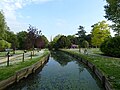
River Lea and Lee Navigation and directly south of Broxbourne. It contains a section of the Lee Valley Park, including much of the River Lee Country Park...
32 KB (3,183 words) - 15:29, 30 August 2024

the River Lee Navigation. Mossops Creek Bridge (completed 2006) forms part of the Mossops Creek permissive path which links the Lee Navigation to the Brimsdown...
9 KB (1,003 words) - 23:23, 25 September 2024
World Wide Web in 1989, when Tim Berners-Lee invented it. Once the World Wide Web was available, web navigation increasingly became a major aspect and role...
10 KB (1,105 words) - 02:31, 19 September 2024

Lee Navigation. Angling is allowed upstream and downstream of Picketts Lock. Information from the River Lea Anglers Club. The River Lee Navigation's towpath...
54 KB (5,859 words) - 15:30, 27 September 2024

and Greater London Urban Area. The area is on the River Lea and the Lee Navigation along with the New River. Hoddesdon is the second most populated town...
30 KB (3,349 words) - 23:53, 17 May 2024

Bow Back Rivers (section Navigation)
was gradually canalised to maintain navigation. Significant changes occurred with the creation of the Lee Navigation in 1767, which resulted in the construction...
39 KB (5,010 words) - 07:03, 16 September 2024

Lea at Hertford to flow east and then south toward the Thames as the Lee Navigation, after Hertford Castle Weir. The shared valley of the Lea and the Beane...
48 KB (4,639 words) - 00:46, 1 September 2024
Barrow Navigation Lower Bann Navigation River Foyle River Lagan Lee Navigation Munster Blackwater & Bride Navigation Shannon Navigation Slaney Navigation Suck...
2 KB (147 words) - 07:10, 28 July 2024
The Lee Conservancy Police was the name given to a body of constables who policed the Lee Navigation, and were maintained by the Lee Conservancy Board...
3 KB (419 words) - 12:20, 25 March 2024

Old Ford Lock (category Locks of the Lee Navigation)
Old Ford Lock is a paired lock and weir on the River Lee Navigation, in the London Borough of Tower Hamlets, England. It is at Fish Island in Old Ford...
5 KB (488 words) - 11:48, 30 November 2023

Hackney Marshes (category Lee Valley Park)
the Old River Lea, and the Hackney Cut – an artificial channel of the Lee Navigation, dug about 1770, to avoid a loop in the natural watercourse. The southern...
18 KB (2,210 words) - 11:36, 5 July 2024
Picketts Lock (category Lee Valley Park)
Edmonton, in the London Borough of Enfield. It is bordered by River Lee Navigation to the east, Pickett's Lock Lane to the south, Meridian Way A1055 to...
7 KB (794 words) - 13:47, 29 November 2023

on its northwestern edge, running along the Hertford Union Canal and Lee Navigation towpaths. NCN1 is a long cycle route between Dover, Kent, and the Shetland...
63 KB (6,903 words) - 15:04, 25 September 2024

Lee Navigation, passing to the west of the Lockwood Reservoir. It continues past Stonebridge Lock and Tottenham Lock, then merges with the River Lee Navigation...
2 KB (241 words) - 11:52, 30 December 2023

runs along Wallis Road and the railway. The core area lies west of the Lee Navigation, here called Hackney Cut, however the parts of the Queen Elizabeth Olympic...
34 KB (3,708 words) - 23:02, 26 September 2024
Blue Ribbon Network (category Lee Navigation)
components of the network are: Grand Union Canal Regent's Canal River Lee Navigation River Brent River Roding River Rom River Crane Beverley Brook River...
2 KB (197 words) - 02:48, 14 May 2020
London River Cray River Darent River Ingrebourne River Lea (or Lee) River Lee Navigation River Moselle New River River Peck River Pool River Quaggy River...
30 KB (1,895 words) - 15:49, 29 February 2024
Hertfordshire spring water to be used in production, whilst proximity of the Lee Navigation and numerous railways meant easy, cheap shipping of coal, sugar, and...
5 KB (489 words) - 04:16, 8 June 2024

Limehouse Cut for barges, which ran under Narrow Street and led to the Lee Navigation, was established in 1766. Limehouse Basin was built in 1820, to transship...
13 KB (1,601 words) - 13:24, 28 August 2024