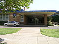
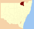
Liverpool Plains Shire is a local government area located in the North West Slopes region of New South Wales, Australia. The Shire was formed on 17 March...
13 KB (1,011 words) - 10:53, 2 October 2024
candidate, while there is also one Independent Labor candidate. Liverpool Plains Shire Council is composed of seven councillors elected proportionally...
64 KB (1,347 words) - 07:03, 9 October 2024

Tree. Most of the region nowadays comes under the jurisdiction of Liverpool Plains Shire Council. However substantial parts of the region also form part...
6 KB (675 words) - 22:10, 25 July 2024
Liverpool Plains Shire was a local government area in the North West Slopes region of New South Wales, Australia. Liverpool Plains Shire was proclaimed...
2 KB (171 words) - 16:12, 29 April 2023
New South Wales Liverpool Plains Shire, a local government area of New South Wales Liverpool River Liverpool, Nova Scotia Liverpool (European Parliament...
3 KB (395 words) - 23:17, 25 August 2024
single ward. Gunnedah Shire Council is composed of nine councillors elected proportionally to a single ward. Liverpool Plains Shire Council is composed...
28 KB (434 words) - 00:35, 6 October 2024

Shire is a local government area in the North West Slopes region of New South Wales, Australia. The Shire is located adjacent to the Liverpool Plains...
12 KB (882 words) - 22:41, 10 September 2024
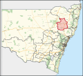
Government Areas include Gunnedah Shire, Liverpool Plains Shire, Moree Plains Shire, Narrabri Shire, Gwydir Shire and Tamworth Regional Council. The...
7 KB (646 words) - 14:06, 7 September 2024
Parry Shire was a local government area in New South Wales, Australia. The former Parry Shire was located in the Liverpool Plains region and covered a...
1 KB (174 words) - 16:20, 29 April 2023

October 2018. Liverpool Plains Shire Council has been considering fluoridation of its water supply since 2018. In November 2013, Byron Shire Council decided...
38 KB (3,783 words) - 10:34, 8 October 2024

Werris Creek (category Liverpool Plains Shire)
is a small town in New South Wales, Australia, near Tamworth, in Liverpool Plains Shire. It is north of Quirindi and is at the junction of the Main North...
9 KB (1,037 words) - 15:38, 27 July 2024

Quirindi (category Liverpool Plains Shire)
the North West Slopes region of New South Wales, Australia, in Liverpool Plains Shire. At the 2021 census, Quirindi had a population of 2,602. It is the...
10 KB (773 words) - 08:24, 25 September 2024
Moree Plains Shire is a local government area in the North West Slopes region of New South Wales, Australia. The northern boundary of the Shire is located...
18 KB (1,195 words) - 10:28, 8 October 2024
Main North railway line, New South Wales (category Liverpool Plains Shire)
Nemingha Tintinhull Kootingal Limbri Danglemah Macdonald River Railway Bridge Woolbrook Walcha Road Wollun Kentucky South Kentucky Uralla Kellys Plains...
23 KB (2,299 words) - 05:49, 30 August 2024

construct a commemorative garden in recognition of these immigrants. Liverpool Plains Shire Council was ultimately the only council to accept his offer to supply...
79 KB (8,598 words) - 07:12, 24 August 2024
Shires to form Liverpool Plains Shire on 17 March 2004. Local Government Areas Amalgamation Act 1980 (NSW) Schedule 1. "Quirindi Shire Council - Sale...
2 KB (161 words) - 13:36, 13 July 2023
the shire north of the Liverpool Range being incorporated into the new Liverpool Plains Shire, and the part of the shire south of the Liverpool Range...
719 bytes (69 words) - 16:17, 29 April 2023

Kamilaroi Highway (category Liverpool Plains Shire)
Tamworth, Port Macquarie Western terminus of eastern section of highway Liverpool Plains Willow Tree 605 376 New England Highway (A15) – Tamworth, Singleton...
17 KB (1,407 words) - 06:37, 13 August 2024
Parraweena, New South Wales (category Liverpool Plains Shire)
population of 61 people in the 2021 census. Parraweena is located in the Liverpool Plains area, and it is about 35 kilometres WSW of the nearest significant...
1 KB (100 words) - 10:28, 9 December 2023

Currabubula (category Liverpool Plains Shire)
Tamworth and 15 km north-east of Werris Creek. Currabubula is in the Liverpool Plains Shire local government area. As of 2016, it had a local population of...
4 KB (278 words) - 12:49, 27 August 2024
entirety of Tamworth Regional Council, Gunnedah Shire, Walcha Shire and a small part of Liverpool Plains Shire around Werris Creek. Tamworth was created in...
11 KB (560 words) - 00:00, 27 March 2023

Willow Tree, New South Wales (category Liverpool Plains Shire)
people, located in New South Wales, Australia. It is situated in the Liverpool Plains, 14 kilometres south of Quirindi near the junction of the Kamilaroi...
5 KB (514 words) - 01:43, 20 June 2024

New England Highway (category Liverpool Plains Shire)
State Highway 24 in New South Wales. Against the wishes of the Beaudesert Shire Council and the Woodenbong Chamber of Commerce, the former alignment of...
41 KB (2,871 words) - 00:51, 9 September 2024

Wallabadah, New South Wales (category Liverpool Plains Shire)
kilometres south of Tamworth on the New England Highway and is in the Liverpool Plains Shire. At the 2021 census, Wallabadah had a population of 382. The Wallabadah...
5 KB (491 words) - 01:23, 9 January 2023
Statistics (27 June 2017). "Western Plains Regional (A)". 2016 Census QuickStats. Retrieved 7 July 2017. "Western Plains Regional Council". Stronger Councils...
52 KB (2,825 words) - 08:12, 19 June 2024

Spring Ridge, New South Wales (category Liverpool Plains Shire)
Spring Ridge is a small town in northeastern New South Wales, Australia. In the 2021 census the population of the town was 266. It is in the electoral...
2 KB (151 words) - 17:58, 19 May 2024
Binnaway–Werris Creek railway line (category Liverpool Plains Shire)
The Binnaway–Werris Creek railway line is a railway line in the northern part of New South Wales, Australia and forms part of a cross country route between...
2 KB (166 words) - 10:59, 29 April 2022

May 2016. Retrieved 13 May 2016. "Wentworth - A Brief History". Wentworth Shire Council. Retrieved 16 February 2020. "Local Government Act, 1919—Proclamation"...
73 KB (2,488 words) - 08:32, 1 October 2024

Caroona (category Liverpool Plains Shire)
Caroona is a small village in Liverpool Plains Shire, New South Wales, Australia. Caroona is located on the Quirindi-Coonabarabran road, about 20 kilometres...
3 KB (160 words) - 01:43, 3 September 2022
"John Rayner leads new Georges River Council". St George & Sutherland Shire Leader. Retrieved 15 May 2016. "PROCLAMATION". New South Wales Government...
152 KB (6,257 words) - 20:35, 14 September 2024