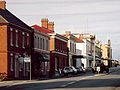
Macquarie Plains is a rural locality in the local government area of Derwent Valley in the South-east region of Tasmania. The locality is about 17 kilometres...
4 KB (227 words) - 17:33, 25 July 2024

have been named in Macquarie's honour (some of these were named by Macquarie himself). They include: Macquarie Island, between Tasmania and Antarctica. The...
65 KB (6,765 words) - 00:08, 3 September 2024

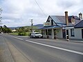
Gretna. It was formerly known as Stony Hut Plains, though the Gretna post office was known as Macquarie Plains for many years. It has a postcode of 7140...
6 KB (427 words) - 02:00, 24 June 2023

separated from Tasmania by the D'Entrecasteaux Channel, Macquarie Island 1,500 km from Tasmania, and Maria Island off the east coast. Tasmania features a...
184 KB (15,529 words) - 14:54, 29 August 2024
Protected areas of Tasmania consist of protected areas located within Tasmania and its immediate onshore waters, including Macquarie Island. It includes...
70 KB (4,158 words) - 03:28, 11 January 2024
Hubert Nichols (category Independent members of the Parliament of Tasmania)
21 August 1940) was an Australian politician. He was born at Macquarie Plains, Tasmania. In 1902 he was elected to the Tasmanian Legislative Council as...
2 KB (87 words) - 05:07, 20 November 2023
town in the northern midlands of Tasmania, Australia. It lies 145 m above sea level at the convergence of the Macquarie River and the South Esk River, 21 km...
19 KB (2,031 words) - 01:00, 2 July 2024

Campbell Town is a town in Tasmania, Australia, on the Midland Highway. At the 2021 census, the town had a population of 823. The traditional custodians...
13 KB (1,353 words) - 10:59, 29 June 2024

tributaries, before reaching its confluence with the River Derwent near Macquarie Plains, west of New Norfolk. The river descends 1,090 metres (3,580 ft) over...
5 KB (286 words) - 09:57, 28 February 2024
Cressy is a small town 35 kilometres (22 mi) south-west of Launceston, Tasmania. It came into existence in the 1850s to service the surrounding wheat farms...
4 KB (330 words) - 11:53, 12 February 2023
locality in 1959. Governor Lachlan Macquarie named the locality "Sorell Plains", and it became locally known as "Macquarie" and "Lower Clyde". Governor George...
10 KB (661 words) - 03:55, 1 September 2024
Fitzgerald Glenfern Glenora Granton Hayes Karanja Lachlan Lawitta Macquarie Plains Magra Malbina Maydena Molesworth Moogara Mount Field Mount Lloyd National...
22 KB (787 words) - 08:22, 21 July 2024

separated from Tasmania by the D'Entrecasteaux Channel, Macquarie Island 1,500 km from Tasmania, and Maria Island off the east coast. Tasmania features a...
51 KB (3,428 words) - 23:59, 11 July 2024

Gloucester Caledon Ulva Jarvis Strangford Macquarie New Norfolk Melville Drummond Queenboro Sussex Clarence Plains Cambridge Forbes Glenorchy Argyle Kingboro...
8 KB (721 words) - 09:46, 29 August 2022

Hobart (redirect from Hobart, Tasmania)
(1938) on Murray Street, the Old Mercury Building on Macquarie Street (1938), the former Hydro Tasmania (1938) and the Colonial Mutual Life buildings (1936)...
144 KB (12,973 words) - 05:19, 7 September 2024

The Midland Highway (also known as the Midlands Highway) is one of Tasmania's major inter-city highways, running for 176 kilometres (109 mi) between Hobart...
14 KB (1,397 words) - 03:33, 24 April 2023

'Black Forest', on the Gordon Plains towards Nile, and on surrounding foothills of the Ben Lomond Tier, but the plains and river flats were attractive...
16 KB (1,995 words) - 05:14, 5 May 2024

Fish and Campbell Rivers and described two plains in his view, the O'Connell Plains and the Macquarie Plains. On 9 December he reached the site of present-day...
38 KB (3,375 words) - 16:13, 24 August 2024

Ross is a village in the Midlands of the state of Tasmania in Australia. On the Macquarie River, Ross is located 78 km south of Launceston and 117 km...
18 KB (1,691 words) - 03:22, 12 August 2024

George Evans (explorer) (category People from Tasmania)
Fish and Campbell Rivers and described two plains in his view, the O'Connell Plains and the Macquarie Plains. It was on 9 December that he reached the...
14 KB (1,548 words) - 07:56, 20 July 2024

Strait and ultimately breaking Tasmania away from Antarctica. In the Cenozoic, a couple of basins extended inland from Macquarie Harbour and the northern Midlands...
80 KB (11,155 words) - 08:47, 14 July 2024
George Town for stealing at Norfolk Plains William Smith - 25 April 1822 - Publicly hanged at the Cascade end of Macquarie Street, Hobart, for sheep stealing...
65 KB (9,228 words) - 16:19, 7 September 2024

is a natural freshwater lake located in the Central Highlands area of Tasmania, Australia. The lake forms the southern end of the Cradle Mountain-Lake...
12 KB (934 words) - 17:24, 25 July 2024
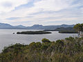
of water located in the southwest corner of Tasmania. The harbour is surrounded by low-lying alluvial plains with mountain ranges running along the western...
8 KB (910 words) - 14:38, 15 April 2023

Frenchmans Cap (redirect from Frenchmans Cap, Tasmania)
highest mountains in Tasmania. The mountain lies east of the West Coast Range, yet due to its prominence, it can be seen from Macquarie Harbour. It lies south...
17 KB (1,941 words) - 14:17, 25 March 2024

Launceston (/ˈlɒnsɛstən/ ) is a city in the north of Tasmania, Australia, at the confluence of the North Esk and South Esk rivers where they become the...
75 KB (7,144 words) - 21:50, 30 July 2024

Aboriginal Tasmanians (category Aboriginal peoples of Tasmania)
Palawa or Pakana) are the Aboriginal people of the Australian island of Tasmania, located south of the mainland. At the time of European contact Tasmanian...
131 KB (15,420 words) - 20:48, 29 August 2024
Port Davey (redirect from Port Davey, Tasmania)
the south west region of Tasmania, Australia. Port Davey was named in honour of Thomas Davey, a former Governor of Tasmania. Port Davey is contained within...
19 KB (1,675 words) - 02:54, 22 June 2024

Invermay Killiekrankie Lachlan Leith Macquarie and Macquarie Plains Macquarie Island Melrose Mount Murchison (Tasmania) Patersonia, an old name for Launceston...
20 KB (991 words) - 07:52, 9 December 2023
Poatina Power Station (redirect from Poatina Power Station, Tasmania)
900-metre (3,000 ft) descent from the Great Western Tiers to the Norfolk Plains in Tasmania's northern Midlands. Water from Great Lake is diverted via a tunnel...
8 KB (506 words) - 22:57, 29 January 2024