
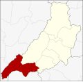
Mae Tha (Thai: แม่ทะ, pronounced [mɛ̂ː tʰáʔ]) is a district (amphoe) of Lampang province, northern Thailand. Neighboring districts are (from the south...
5 KB (283 words) - 00:58, 4 September 2024
Mae Tha may refer to: Mae Tha District, Lampang Mae Tha District, Lamphun Mae Tha Subdistrict, Chiang Mai This disambiguation page lists articles about...
160 bytes (52 words) - 07:53, 29 December 2019
amphoe (districts) named Mae Tha in Thailand, which, however, have two different Thai spellings Amphoe Mae Tha, Lampang province (แม่ทะ) Amphoe Mae Tha, Lamphun...
286 bytes (63 words) - 03:13, 17 June 2023

Mae Tha is a railway station located in Mae Tha Subdistrict, Mae Tha District, Lampang. It is located 628.445 km from Bangkok railway station and is a...
1 KB (96 words) - 05:11, 26 April 2024

Chin of Phrae province; Mae Tha and Mae Mo of Lampang province. The Phi Pan Nam Mountains dominate the landscape of the district. Doi Pha Klong National...
3 KB (124 words) - 00:55, 4 September 2024

Neighboring districts are (from the north clockwise): Mueang Pan, Chae Hom, Mae Mo, Mae Tha, Ko Kha and Hang Chat of Lampang Province, Mae Tha of Lamphun...
5 KB (225 words) - 00:58, 4 September 2024

old name of Lampang was Khelang Nakhon. Lampang is in the broad river valley of the Wang River, surrounded by mountains. In Mae Mo district lignite is...
20 KB (1,361 words) - 23:30, 1 October 2024

Lat railway station is a railway station located in Mae Tha Subdistrict, Mae Tha District, Lampang. It is located 622.209 km from Bangkok railway station...
1 KB (91 words) - 09:24, 21 August 2024

Lampang, Ko Kha, Soem Ngam of Lampang Province and Mae Tha of Lamphun province. The Khun Tan Range stretches from north to south along the district....
4 KB (165 words) - 00:58, 4 September 2024
Tha Pha can refer to: Tha Pha, a tambon of Ko Kha District, Lampang Province, Thailand Tha Pha, a tambon of Ban Pong District, Ratchaburi Province, Thailand...
313 bytes (73 words) - 14:12, 5 September 2011

northern Thailand. Neighboring districts are (from the south clockwise): Mae Tha, Mueang Lampang, Chae Hom and Ngao of Lampang Province, Song and Long of...
8 KB (682 words) - 00:58, 4 September 2024

Mae Tha (Thai: แม่ทา; IPA: [mɛ̂ː tʰāː]) is a district (amphoe) of Lamphun province, northern Thailand. The district is named after the Mae Tha River. The...
5 KB (251 words) - 00:57, 4 September 2024

Chat, Mueang Lampang, Mae Tha of Lampang Province. The Khun Tan Range rises in the west and the Phi Pan Nam Range in the east of the district. In 1917 the...
4 KB (160 words) - 00:58, 4 September 2024

Nuea of Lampang province. Doi Luang, the highest point of the Phi Pan Nam Range is at the western end of the district. In 1917 Phayao district was renamed...
8 KB (500 words) - 00:56, 4 September 2024

Mueang Lampang of Lampang province, Ban Thi, Mueang Lamphun and Mae Tha of Lamphun province. Mae Ta Krai National Park protects the source of the On River (น้ำแม่ออน)...
7 KB (421 words) - 04:14, 5 October 2024
province; Thoen, Sop Prap, and Mae Tha of Lampang province. The Phi Pan Nam Mountains dominate the landscape of the district. Wiang Kosai National Park is...
6 KB (328 words) - 00:55, 4 September 2024

which lies in region 13 (Lampang branch) of Thailand's protected areas. Mae Ping National Park, 1,004 km2 (388 sq mi): 31 Mae Takrai National Park, 354 km2...
16 KB (1,118 words) - 12:13, 3 October 2024

defeated Burmese invaders. Neighboring districts are (from the south clockwise): Thoen, Soem Ngam, Ko Kha, Mae Tha of Lampang Province and Wang Chin of Phrae...
5 KB (286 words) - 00:58, 4 September 2024

Ban Tak, Mae Ramat of Tak Province, Omkoi, Doi Tao of Chiang Mai province, Thung Hua Chang of Lamphun province, Mae Phrik and Thoen of Lampang province...
5 KB (286 words) - 00:51, 4 September 2024

districts are (south from clockwise): Mueang Tak, Mae Ramat, Sam Ngao of Tak Province, Thoen of Lampang province and Ban Dan Lan Hoi of Sukhothai province...
4 KB (231 words) - 00:51, 4 September 2024
been found at Tham Lod Rockshelter in Mae Hong Son.[citation needed] Modern Thais are not descendants of Lampang Man. Genetic research supports this assertion...
15 KB (1,823 words) - 23:00, 17 August 2024
Mae Mo railway station is a railway station located in Sop Pat Subdistrict, Mae Mo District, Lampang. It is located 609.168 km from Bangkok railway station...
1 KB (135 words) - 15:12, 14 September 2024

is bordered by Chiang Rai to the northeast, Lampang and Lamphun to the south, Tak to the southwest, Mae Hong Son to the west, and Shan State of Burma...
36 KB (2,763 words) - 20:52, 17 September 2024

Thailand, Wang chin District of Phrae province and Mae tha, Toen, Sop prab District of Lampang Province. Mae Koeng is a large waterfall. The water flows all...
4 KB (327 words) - 14:02, 7 January 2022

Thailand. Neighbouring provinces are (from north clockwise) Mae Hong Son, Chiang Mai, Lamphun, Lampang, Sukhothai, Kamphaeng Phet, Nakhon Sawan, Uthai Thani...
23 KB (1,724 words) - 00:22, 4 September 2024
BMR Nakhon Ratchasima Chiang Mai Lampang Hat Yai Udon Thani Khon Kaen Ubon Ratchathani Nakhon Si Thammarat Nakhon Sawan Nakhon Pathom Phitsanulok Pattaya...
49 KB (1,110 words) - 14:05, 5 August 2024

Thoen of Lampang Province, Thung Hua Chang and Mae Tha of Lamphun province. The Khun Tan Range stretches from north to south along the district. Soem Ngam...
5 KB (276 words) - 00:58, 4 September 2024
of 31 December 2018[update] there were 878 districts (amphoe) in Thailand. This table lists those districts, and the provinces (changwat) of Thailand and...
122 KB (104 words) - 15:57, 17 October 2023

and Chiang Kham districts (many in number) Lampang: Mueang Lampang and Mae Tha districts Lamphun: Mueang Lamphun and Ban Thi districts The festivals of...
24 KB (2,627 words) - 13:04, 18 September 2024

Ping River (redirect from Mae Ping)
(120 sq mi). Wang River, the main tributary of the Ping, flowing through Lampang Confluence of the Ping with the Nan River at Nakhon Sawan Wikimedia Commons...
10 KB (1,154 words) - 00:43, 4 September 2024