
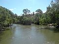
The Moogerah Dam is a mass concrete double curvature arch dam with an un-gated spillway across Reynolds Creek in South East Queensland, Australia, now...
12 KB (1,124 words) - 05:43, 23 September 2023
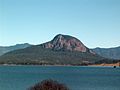
protected areas which surround volcanic peaks and rocky cliffs near Moogerah Dam. Because the peaks are relatively inaccessible the natural vegetation...
4 KB (370 words) - 13:18, 16 December 2020
Cunningham Highway state-controlled roads (redirect from Lake Moogerah Road)
View–Peak Crossing Road Kalbar Connection Road Boonah–Fassifern Road Lake Moogerah Road New England Highway Freestone Road Warwick–Yangan Road Warwick–Allora...
22 KB (1,802 words) - 22:38, 9 February 2024

people. The Moogerah Dam (28°01′46″S 152°32′59″E / 28.0294°S 152.5497°E / -28.0294; 152.5497 (Moogerah Dam)) and its reservoir, Lake Moogerah (28°03′00″S...
11 KB (1,127 words) - 00:33, 28 May 2024

Wummun. The summit is accessed by walking track that starts across the Moogerah Dam wall. The 2.7 km walk to the top affords views across Fassifern Valley...
4 KB (270 words) - 22:54, 3 July 2023

Fassifern Valley (section Moogerah Dam)
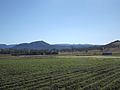
Cunninghams Gap, Mount Mitchell and parts of the Main Range National Park. The Moogerah Peaks are a series of mountain peaks in the southeast of the catchment...
7 KB (678 words) - 06:56, 3 April 2024

(primary coordinates) GPX (secondary coordinates) Dams and reservoirs in Australia is a link page for any dam or reservoir in Australia. There are three key...
76 KB (509 words) - 20:29, 25 September 2023

Rathdowney, Beechmont and Harrisville. The peak at Mount French, part of Moogerah Peaks National Park is noted for its traditional rock climbing and does...
26 KB (1,185 words) - 01:25, 15 July 2024

Fassifern Valley State School (1958), Charlwood State School (1958), Moogerah Dam State School (1961), Silverdale State School (1963), and Frazerview State...
30 KB (2,788 words) - 03:10, 14 June 2024

occurred in 1917, 1935—36, 1941 and 1965.: 97 Moogerah Dam was built in the upper reaches of Reynolds Creek. The dam provides potable water for towns such as...
21 KB (1,679 words) - 05:52, 24 August 2023

doubled, irrigated land doubled, and a number of projects such as the Moogerah Dam were undertaken. Mining boomed – total mining output almost trebled,...
23 KB (2,411 words) - 02:31, 31 May 2024
Mount Lindesay Highway state-controlled roads (redirect from Maroon Dam Road)
associated with the intersecting roads described above: Maroon Dam Road Carneys Creek Road Maroon Dam Road is a state-controlled district road (number 2133),...
6 KB (516 words) - 02:20, 5 March 2024
(former)) Located at 1601 Lake Moogerah Road. Moogerah Dam State School Moogerah Scenic Rim 1959 1961 The Moogerah Dam was under construction between...
150 KB (4,508 words) - 17:29, 25 July 2024

Fassifern Valley, Charlwood, Silverdale, Obum Obum, Frazerview and Moogerah Dam Provisional School, Engelsburg State School Centenary Celebrations Association...
10 KB (808 words) - 08:49, 30 June 2024

Fassifern Valley, Charlwood, Silverdale, Obum Obum, Frazerview and Moogerah Dam Provisional School, Engelsburg State School Centenary Celebrations Association...
5 KB (403 words) - 16:59, 25 July 2024

Mount Moon. Directly to the north and west of Mount Alford is Moogerah Dam and the Moogerah Peaks. The larger settlement of Boonah is located nearby with...
20 KB (1,901 words) - 07:37, 25 June 2024

Boonah – Charlwood – Coulson – Fassifern – Harrisville – Kalbar – Maroon – Moogerah – Mount Alford – Mount Walker – Roadvale – Rosevale – Silverdale – Tarome...
35 KB (1,261 words) - 02:04, 12 May 2024

Fassifern Valley, Charlwood, Silverdale, Obum Obum, Frazerview and Moogerah Dam Provisional School, Engelsburg State School Centenary Celebrations Association...
10 KB (745 words) - 03:33, 30 May 2024
Fassifern Valley, Charlwood, Silverdale, Obum Obum, Frazerview and Moogerah Dam Provisional School, Engelsburg State School Centenary Celebrations Association...
6 KB (410 words) - 10:30, 26 May 2024

Fassifern Valley, Charlwood, Silverdale, Obum Obum, Frazerview and Moogerah Dam Provisional School. Engelsburg State School Centenary Celebrations Association...
9 KB (683 words) - 16:59, 25 July 2024

The Maroon Moogerah Fish Management Association is the local fish stocking group. A stocked impoundment permit is required to fish in the dam. Queensland...
9 KB (620 words) - 05:41, 23 September 2023
walls of Cressbrook, Hinze, Maroon, Moogerah, North Pine, Somerset, and Wivenhoe Dams and lakes Dyer (Bill Gunn dam) and Clarendon- the fish is a no-take...
6 KB (661 words) - 13:13, 23 November 2023

Burnett Highway (redirect from Wuruma Dam Road)
Mundubbera–Durong Road Eidsvold–Theodore Road Wuruma Dam Road Monto–Mount Perry Road Gladstone–Monto Road Cania Dam Road Gavial–Gracemere Road Murgon–Barambah Road...
15 KB (930 words) - 06:03, 27 April 2024
Fassifern Valley, Charlwood, Silverdale, Obum Obum, Frazerview and Moogerah Dam Provisional School, Engelsburg State School Centenary Celebrations Association...
5 KB (355 words) - 06:18, 29 May 2024
is heavily influenced by the national parks of Tamborine, Mount Barney, Moogerah Peaks, Main Range and the Lamington Plateau, and numerous local government-owned...
20 KB (1,810 words) - 00:19, 1 April 2024

Gillies Highway (redirect from Tinaroo Falls Dam Road)
Atherton Tableland. It then passes north of Lake Barrine and south of Tinaroo Dam before reaching Yungaburra, where it passes the exit to Malanda-Lake Barrine...
13 KB (1,060 words) - 08:29, 28 July 2024
Bruce Highway state-controlled roads (redirect from Burdekin Falls Dam Road)
(LRRS). It runs from the Bruce Highway in Proserpine to the Peter Faust Dam in Lake Proserpine, a distance of 27.7 kilometres (17.2 mi). It does not...
40 KB (3,348 words) - 15:45, 4 April 2024

through Toowoomba. Coolmunda Dam, Leslie Dam, Cooby Dam, Perseverance Dam, Cressbrook Dam, Storm King Dam and the Glenlyon Dam are some of the major water...
35 KB (3,208 words) - 03:45, 30 June 2024

Highway from Esk to the D'Aguilar Highway. The highway crosses the Wivenhoe Dam about 9 km (6 mi) north-west of Fernvale. Brisbane Valley Highway is a state-controlled...
13 KB (784 words) - 12:20, 15 July 2024

2022. A project to develop supporting road infrastructure for the Emu Swamp Dam, adjacent to the New England Highway at Stanthorpe, at a cost of $6.3 million...
41 KB (2,888 words) - 17:00, 20 May 2024