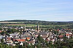
Birkenfeld (redirect from Birkenfeld (Nahe))
itself has approximately 7,000 inhabitants. The town lies in the Nahegebiet (Nahe area), to the north of the namesake river, on the edge of the Naturpark Saar-Hunsrück...
32 KB (3,696 words) - 13:59, 20 August 2024

state of Saarland. The station is located at line-kilometer 106.3 of the Nahe Valley Railway (Nahetalbahn) and was the beginning of the now dismantled...
7 KB (517 words) - 22:57, 13 August 2024

the Keltenweg Nahe–Mosel (likewise) and the Lützelsoon-Radweg (cycle path), as well as being a stage on the Nahe-Hunsrück-Mosel-Radweg (another cycle...
74 KB (9,539 words) - 05:05, 24 January 2024

The Weinwanderweg Rhein-Nahe ("Rhine-Nahe Wine Hiking Trail"), the Nahe-Radweg ("Nahe Cycle Way") and the Naheweinstraße ("Nahe Wine Road") all run through...
79 KB (10,383 words) - 18:58, 4 January 2024

“bike-and-ride” facility is located at the station to serve riders on the Nahe cycleway (Nahe-Radweg). From Monday to Sunday there is an hourly service by Regional-Express...
7 KB (435 words) - 14:00, 13 August 2024

with outstanding views, and all furnished with benches for resting. The Nahe-Radweg, a 120 km-long cycle path, opens to the cyclist the Naheland from the...
29 KB (3,149 words) - 18:45, 16 April 2024
River Nahe, follows the course of the Glan, crosses the state of Saarland along the Blies and finishes in Lorraine in France. The way begins on the Nahe Cycleway...
6 KB (552 words) - 06:32, 29 July 2024

cycle path that leads by way of Rehborn and Odernheim am Glan to the Nahe-Radweg (a major cycle path) at Staudernheim. There is also draisine touring...
21 KB (2,374 words) - 18:49, 16 April 2024

central location right near three rivers, the Moselle, the Rhine and the Nahe, each about 25 km away, allowing easy day trips to other nearby places. Simmern...
29 KB (3,310 words) - 09:41, 20 August 2024

eastern Hunsrück roughly equidistant from the Moselle, the Rhine and the Nahe. The town centre lies between a depression in the north and the plateau of...
21 KB (2,564 words) - 17:21, 4 March 2024
"Bahntrassenradeln – Details – Deutschland > Rheinland-Pfalz > südl. der Nahe - RP 3.08 Glan-Blies-Radweg: Abschnitt Staudernheim – Waldmohr" (in German). achim-bartoschek...
34 KB (4,199 words) - 09:06, 11 June 2024

whereupon the combined stream is known down to its mouth into the river Nahe as the Kellenbach. The outlying centre of Panzweiler is part of Gemünden...
10 KB (1,071 words) - 16:14, 20 August 2024

Odenbach (Glan) (category Tributaries of the Nahe)
on German terrain maps (Deutscher Grundkarte) 1:5000 series Odenbachtal Radweg. Tourenplaner Rheinland-Pfalz, Die Pfalz Taken from the flur name Kirschgraben...
15 KB (618 words) - 06:43, 21 September 2022

"Bahntrassenradeln – Details - Deutschland > Rheinland-Pfalz > südl. der Nahe - RP 3.08 Glan-Blies-Radweg: Abschnitt Staudernheim – Waldmohr" (in German). achim-bartoschek...
29 KB (3,497 words) - 14:36, 15 August 2024

The Freiherr von Drais Radweg (“Baron von Drais Cycle Path”) leads in a loop round the town for 14 km. The Lützelsoon-Radweg, another cycle path, to...
27 KB (3,420 words) - 13:23, 4 August 2021

linked to the Hunsrück's hiking and cycle path (Schinderhannes-Soonwald-Radweg) network between Simmern and Gemünden. Many kinds of outings are possible...
11 KB (1,177 words) - 06:47, 10 May 2024