off Clatsop County, and is barely south of the mouth of the Columbia River and Astoria Canyon. Nehalem Bank is north of Nehalem Bay. Nehalem Bank is one...
9 KB (521 words) - 21:01, 14 June 2023

well as the unrecognized Chinook Indian Nation and Clatsop-Nehalem Confederated Tribes. The name Clatsop comes from tɬác̓əp, meaning "those who have pounded...
14 KB (1,380 words) - 01:07, 8 September 2024

the county and the highest in the Northern Oregon Coast Range. The county has been called "a natural cow pasture" by Sunset Magazine". Clatsop County (north)...
25 KB (2,494 words) - 10:57, 19 September 2024

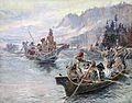
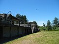
Fort Clatsop was the encampment of the Lewis and Clark Expedition in the Oregon Country near the mouth of the Columbia River during the winter of 1805–1806...
15 KB (1,836 words) - 04:25, 14 January 2024
Chinookan peoples (category Native American tribes in Oregon)
Tchinouk Indians of Oregon do not meet the requirements necessary to be a federally recognized tribe. The unrecognized Clatsop-Nehalem Confederate Tribes...
27 KB (2,879 words) - 06:57, 5 October 2024

Portlandia, Grimm, Bates Motel, and Leverage. The Oregon Film Museum is located in the old Clatsop County Jail in Astoria. Additionally, the last remaining...
196 KB (16,672 words) - 12:34, 19 September 2024
Tillamook Head (redirect from Tillamook Head, Oregon)
promontory on the Pacific coast of northwest Oregon in the United States. It is located in west-central Clatsop County, approximately 5 mi (8 km) southwest of...
3 KB (240 words) - 21:20, 14 August 2024
Heavy rains caused the Nehalem River to escape its banks and flood the city of Vernonia and rural areas nearby. Columbia County received a presidential...
26 KB (2,286 words) - 04:31, 6 October 2024
several sites on the north bank of the river in Washington and other sites in Oregon. The federal park began as Fort Clatsop National Memorial which was...
10 KB (768 words) - 10:05, 4 December 2023

Clifton (Clatsop County) - Clifton (Hood River County) - Cloverdale (Deschutes County) - Cloverdale (Lane County) - Cloverdale (Tillamook County) - Coburg...
41 KB (1,679 words) - 14:25, 29 September 2024

Nehalem Bay State Park is a state park in the United States located on the Oregon Coast, near the communities of Nehalem and Manzanita on the Nehalem...
3 KB (270 words) - 01:21, 3 August 2023
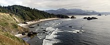
The Oregon Coast includes Clatsop County, Tillamook County, Lincoln County, western Lane County, western Douglas County, Coos County, and Curry County. The...
53 KB (5,843 words) - 11:04, 13 September 2024
The Nehalem Highway No. 102 (see Oregon highways and routes) is a state highway in the U.S. state of Oregon that passes through the Nehalem River valley...
6 KB (364 words) - 01:11, 31 July 2023

north to south they are Clatsop, Tillamook, Lincoln, Lane, Coos, and Curry counties. (Douglas County is the only coastal Oregon county not included in the...
8 KB (601 words) - 10:48, 19 November 2023

there through the Oregon Coast Range, providing access to Saddle Mountain and passing through the valleys of the Necanicum and Nehalem rivers. It then crosses...
25 KB (1,490 words) - 15:33, 21 March 2024

Clatsop State Forest is a state forest in Clatsop and Columbia counties in the U.S. state of Oregon. It is managed by the Astoria District of the Oregon...
2 KB (67 words) - 02:29, 1 April 2022
of counties in Oregon List of census-designated places in Oregon List of ghost towns in Oregon "Incorporated Places and Minor Civil Divisions: Oregon"....
44 KB (227 words) - 00:03, 20 July 2024
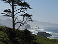
Ecola State Park (redirect from Indian Beach (Oregon))
8 km) north of Cannon Beach in Clatsop County in the U.S. state of Oregon on the Oregon Coast. It is administered by the Oregon Parks and Recreation Department...
8 KB (679 words) - 09:06, 14 July 2024

Hug Point State Recreation Site (redirect from Hug Point (Oregon))
Recreation Site is a state park on the northern Oregon Coast in the U.S. state of Oregon. Administered by the Oregon Parks and Recreation Department, the park...
5 KB (451 words) - 19:00, 1 May 2024

Illinois River Imnaha River John Day River (north central Oregon) John Day River (Clatsop County) Johnson Creek Joseph Creek Kellogg Creek Kiger Creek Kings...
97 KB (11,400 words) - 16:41, 4 August 2024

provisional government of the Oregon Country. The town site is on the south bank of the Willamette River in northern Marion County, on French Prairie, approximately...
12 KB (997 words) - 18:14, 18 December 2023

historic districts in Oregon that are listed on the National Register of Historic Places. There are listings in all of Oregon's 36 counties. The National Register...
11 KB (556 words) - 21:47, 4 September 2024
ship Peter Iredale took refuge at Fort Stevens, after she ran aground on Clatsop Spit. The wreck is visible today, within the boundaries of Fort Stevens...
11 KB (1,025 words) - 03:46, 7 October 2024

Tillamook Rock Light (category National Register of Historic Places in Clatsop County, Oregon)
Terrible Tilly or just Tilly) is a deactivated lighthouse on the northern Oregon Coast of the United States. It is located approximately 1.2 miles (1.9 km)...
15 KB (1,786 words) - 21:16, 21 September 2024

The Banks–Vernonia State Trail is a paved rail trail and state park in northwest Oregon in the United States. It runs for 21 miles (34 km), primarily...
8 KB (690 words) - 23:00, 17 July 2024
Arcadia Beach State Recreation Site (redirect from Arcadia Beach (Oregon))
Arcadia Beach State Recreation Site is a beach and state park on the Oregon Coast of the United States located two miles south of Cannon Beach. Under the...
2 KB (105 words) - 01:00, 7 October 2024

The Oregon Dunes National Recreation Area is located on the Oregon Coast, stretching approximately 40 miles (64 km) north of the Coos River in North Bend...
16 KB (1,678 words) - 19:22, 4 August 2024

of Cape Kiwanda State Natural Area List of Oregon state parks Haystack Rock in Cannon Beach, Clatsop County "Cape Kiwanda State Natural Area". Geographic...
3 KB (223 words) - 19:48, 22 February 2024

Bar system which consists of several bars, including Peacock Spit and Clatsop Spit outside the jetties. Inside, in the Columbia River proper are Jetty...
40 KB (138 words) - 01:14, 11 April 2022

Saddle Mountain State Natural Area (category Parks in Clatsop County, Oregon)
Area is a state park in northwest Oregon. It is located in the Northern Oregon Coast Range in central Clatsop County, about 20 miles (32 km) by road from...
6 KB (687 words) - 18:21, 3 August 2024