
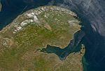
46.083°N 63.583°W / 46.083; -63.583 The Northumberland Strait (French: détroit de Northumberland) is a strait in the southern part of the Gulf of Saint...
13 KB (1,388 words) - 15:22, 15 January 2024
A Northumberland Strait iceboat is a rowing boat, typically 5 metres (16 ft 5 in) in length, 2 metres (6 ft 7 in) in beam, with runners fastened to the...
5 KB (466 words) - 19:51, 28 July 2023
ghostlore, the Ghost Ship of Northumberland Strait is a ghost ship said to sail ablaze within the Northumberland Strait, the body of water that separates...
5 KB (581 words) - 03:38, 27 September 2023
carrying the Trans-Canada Highway across the Abegweit Passage of the Northumberland Strait, linking the province of Prince Edward Island with the mainland...
32 KB (3,711 words) - 20:28, 31 July 2024
carries the Trans-Canada Highway across the eastern part of the Northumberland Strait between Wood Islands, Prince Edward Island and Caribou, Nova Scotia...
12 KB (801 words) - 06:58, 3 August 2024
Northumberland County, Ontario Northumberland County, New Brunswick Northumberland Strait, adjacent to Prince Edward Island Northumberland Sound, at the west end...
2 KB (276 words) - 21:12, 12 June 2023
Abegweit Passage is the narrowest part of the Northumberland Strait, comprising the 13-kilometre (8.1 mi) wide portion between Cape Traverse, Prince Edward...
2 KB (163 words) - 16:50, 13 November 2023

at its narrowest). The strait connects Chedabucto Bay on the Atlantic Ocean to St. George's Bay on the Northumberland Strait, a subbasin of the Gulf...
4 KB (449 words) - 03:07, 20 August 2024
across the Northumberland Strait between Prince Edward Island and New Brunswick Abegweit Passage, the narrowest part of the Northumberland Strait This disambiguation...
675 bytes (124 words) - 15:55, 6 December 2016
the Bay of Fundy, from those of Baie Verte, a sub-basin of the Northumberland Strait that is an arm of the Gulf of St. Lawrence. The isthmus stretches...
22 KB (2,792 words) - 00:57, 16 September 2023
Brunswick. It is a sub-basin of the Northumberland Strait. Baie Verte is one of the larger bays of the Northumberland Strait with its northerly limits at Cape...
5 KB (265 words) - 20:34, 23 May 2023
Atlantic Ocean through four unique watersheds: the Gulf of Maine, the Northumberland Strait, the Gulf of Saint Lawrence and into the Atlantic Ocean itself....
6 KB (717 words) - 23:25, 15 July 2024

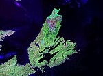
located in the Gulf of St. Lawrence, about 10 km (6 miles) across the Northumberland Strait from both Nova Scotia and New Brunswick. It is about 200 kilometres...
126 KB (11,829 words) - 17:16, 20 August 2024
and passenger ferry which operated across the Abegweit Passage of Northumberland Strait, connecting Port Borden to Cape Tormentine between 1947 and 1982...
6 KB (558 words) - 18:45, 3 December 2023

located on the north coast of eastern mainland Nova Scotia, on the Northumberland Strait, and is connected to the town of Antigonish to the southeast and...
4 KB (385 words) - 21:36, 2 February 2023

district in southeastern New Brunswick, Canada. It is located on the Northumberland Strait at the Abegweit Passage, the shortest crossing between Prince Edward...
5 KB (586 words) - 16:58, 25 December 2023

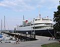
Holiday Island was a Canadian RORO ferry that operated across the Northumberland Strait between the ports of Wood Islands, Prince Edward Island and Caribou...
11 KB (1,094 words) - 11:49, 13 June 2024

1984) Northumberland Strait MV Abegweit (1982) (sold, renamed Accrued Mariner, scrapped) MV John Hamilton Gray (also operated on Cabot Strait service...
22 KB (2,239 words) - 15:29, 12 August 2024
Lawrence with its western coast forming the eastern limits of the Northumberland Strait. The eastern and southern coasts front the Atlantic Ocean with its...
67 KB (7,117 words) - 20:57, 30 July 2024

causeway completely blocks the Strait of Canso, which links the waters of St. George's Bay in the Northumberland Strait, a sub-basin of the Gulf of St...
5 KB (354 words) - 20:27, 1 November 2022

Theodore Tugboat (redirect from Northumberland Submarine)
all in Inverness County, Nova Scotia. Northumberland (the submarine) is named after the Northumberland Strait, a body of water that lies between New...
53 KB (5,783 words) - 00:00, 19 August 2024

There is another Kouchibouguac River that empties into the Northumberland Strait at Beaubassin East in New Brunswick. The Kouchibouguac River is a river...
1 KB (170 words) - 04:17, 28 November 2021
Virgin Gorda Amet Sound on the northern coast of Nova Scotia on the Northumberland Strait Barkley Sound on the west coast of Vancouver Island, British Columbia...
12 KB (1,305 words) - 10:26, 13 July 2024

the northwest, the Northumberland Strait to the north, and the Strait of Canso to the east. The narrow and deep waters of the Strait of Canso separate...
9 KB (978 words) - 15:03, 23 June 2024

passenger ferries which operated across the Abegweit Passage of Northumberland Strait, connecting Borden-Carleton, Prince Edward Island to Cape Tormentine...
8 KB (994 words) - 11:56, 9 June 2024

and passenger ferry which operated across the Abegweit Passage of Northumberland Strait, connecting Port Borden to Cape Tormentine between 1968–1997. John...
8 KB (839 words) - 20:05, 1 August 2023

46°0′N 64°0′W / 46.000°N 64.000°W / 46.000; -64.000 (Northumberland Strait) Northumberland Strait 46°0′N 62°54′W / 46.000°N 62.900°W / 46.000; -62.900...
8 KB (123 words) - 01:49, 8 August 2023

Pictou Island is a Canadian island located in the Northumberland Strait approximately seven kilometres (four nautical miles) north of Nova Scotia and...
4 KB (525 words) - 22:45, 28 July 2024
kilometres to the south where the Fireship of Northumberland Strait has been seen in the Northumberland Strait. This may have given rise to a phantom ship...
12 KB (1,328 words) - 11:13, 11 August 2024
community in Pictou County, Nova Scotia, Canada. Located on the Northumberland Strait northwest of the town of Pictou, Caribou is named after the Woodland...
3 KB (319 words) - 16:52, 15 July 2024