
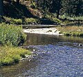
The Payette River (/peɪˈɛt/) is an 82.7-mile-long (133.1 km) river in southwestern Idaho and a major tributary of the Snake River. Its headwaters originate...
20 KB (1,973 words) - 15:58, 15 September 2024
Payette may refer to: Payette, Idaho Payette County, Idaho Payette Lake, a natural lake in southwestern Idaho Payette National Forest, Idaho Payette Peak...
966 bytes (143 words) - 08:19, 16 June 2021

after the Payette River, which was named after French-Canadian François Payette. Originally a fur trapper with the North West Company, Payette was the first...
18 KB (1,446 words) - 00:29, 7 August 2024

Meadows, ID) to mouth (Payette River, ID) Dams are listed in order from headwater (near Vernon Lake, ID) to mouth (Payette River, ID) Dams are listed in...
145 KB (5,874 words) - 04:41, 7 June 2024

Payette is a city in and the county seat of Payette County, Idaho, United States. The population was 7,433 at the 2010 census. It is part of the Ontario...
18 KB (1,273 words) - 03:43, 11 March 2024
Owyhee River North Fork Payette River North Fork Salmon River Orofino Creek Owyhee River Pack River Palouse River Pahsimeroi River Panther Creek Payette River...
12 KB (943 words) - 00:30, 11 June 2024
it is situated in the upper drainage basin of the Payette River, which drains into the Snake River. Outflow from the lake at its southwest corner is regulated...
6 KB (512 words) - 14:00, 27 July 2024
Silver Creek (Idaho) (category Idaho river stubs)
of the Little Wood River in Blaine County, north of Picabo, and the other is a tributary of the Middle Fork of the Payette River in Boise County, near...
3 KB (283 words) - 04:56, 27 October 2022
December 31, 1992. Retrieved January 15, 2024. "USGS Gage #13251000 Payette River near Payette, ID: Water-Data Report 2013" (PDF). National Water Information...
154 KB (16,214 words) - 05:19, 5 October 2024

Idaho State Highway 55 (redirect from Payette River Scenic Byway)
Meridian, and Eagle, then north to Horseshoe Bend. SH-55 then climbs the Payette River to Banks, then its north fork to the Long Valley, through the towns...
14 KB (1,077 words) - 18:53, 4 June 2024
is a town on the southern bank of the Payette River that grew up around a ferry crossing of the Payette River. Emmett was originally called Martinsville...
21 KB (1,632 words) - 07:30, 26 July 2024

of Idaho below 114° 30', excluding the territory lying west of the Payette River. They established its county seat at what later became Idaho City. The...
27 KB (2,368 words) - 23:08, 18 August 2024

Payette River (/peɪˈɛt/) is a river in the western United States in western Idaho. It flows about 113 miles (182 km) southwards from the Salmon River...
6 KB (403 words) - 15:36, 8 August 2024

It is named for its location at the horseshoe-shaped U-turn of the Payette River, whose flow direction changes from south to north before heading west...
16 KB (1,361 words) - 22:33, 14 November 2023

Julie Payette CC CMM COM CQ CD FCAE (French pronunciation: [ʒyli pajɛt]; born October 20, 1963) is a Canadian engineer, scientist and former astronaut...
72 KB (5,828 words) - 02:10, 30 September 2024

after the Long Valley of the North Fork of the Payette River, which extends over 30 miles (50 km) from Payette Lake at McCall south to Cascade to Round Valley...
20 KB (1,941 words) - 00:34, 24 April 2024

County, and climbs the whitewater of the Payette River to Cascade and McCall. The route turns west at Payette Lake in McCall and ends at New Meadows in...
31 KB (3,016 words) - 05:08, 24 September 2024
south. North of the South Fork Payette River and east of the North Fork Payette River, the forest is part of the Salmon River Mountains, which extend north...
62 KB (5,861 words) - 10:42, 1 October 2024

Railroad. It is a significant cultural and historical resource in the Payette River Scenic Byway corridor in the city of New Meadows, at the junction of...
20 KB (1,619 words) - 23:03, 14 February 2024

a reservoir in the western United States, on the North Fork of the Payette River in Valley County, Idaho. Located in the Boise National Forest, it has...
7 KB (571 words) - 23:36, 23 July 2024

SH-55 - Payette River Scenic Byway Donnelly is approximately 85 miles (137 km) north of Boise, accessed via State Highway 55, the Payette River Scenic...
12 KB (1,140 words) - 13:17, 3 September 2024

The Deadwood River is a 43.5-mile (70.0 km) tributary of the South Fork Payette River, flowing through Boise National Forest in Valley and Boise counties...
4 KB (191 words) - 16:12, 14 September 2022

Joseph, Oregon – and the Payette Subdivision Payette through Emmett and then into the canyon of the North Fork of the Payette River northward to Cascade....
8 KB (903 words) - 12:26, 3 March 2024

the Payette River. Under Washington Territory, the area was part of Idaho County from the time of settlement until the territory south of the Payette River...
23 KB (1,923 words) - 00:32, 24 April 2024

and main Salmon Rivers. In 1873, the southern border was moved north to the divide between the main Salmon River with the Payette River and Middle Fork...
29 KB (2,687 words) - 15:40, 12 September 2024

owned a cabin near Grandjean, Idaho, on the upper South Fork of the Payette River, where he would regularly retreat. In 1961, he recorded two albums of...
22 KB (2,495 words) - 15:46, 4 September 2024
States. It is nestled along the north bank of the South Fork of the Payette River in the central part of the state, at an elevation of 3,800 feet (1,160 m)...
7 KB (681 words) - 22:32, 19 July 2024

Idaho (redirect from List of lakes and rivers of Idaho)
Moyie River North Fork Clearwater River Pack River Payette Lake, (McCall) Pettit Lake Priest Lake Perkins Lake Portneuf River Redfish Lake Salmon River Sawtooth...
105 KB (8,415 words) - 15:28, 5 October 2024

living along the Salmon River, Salmon River Mountains, in the Sawtooth Valley surrounded by the Sawtooth Range, upper Payette River, in the Bitterroot Mountains...
12 KB (1,416 words) - 18:48, 6 May 2023

components than any other wilderness. In descending order of acreage they are: Payette National Forest (33.45%) Challis National Forest (21.78%) Salmon National...
17 KB (1,546 words) - 23:04, 29 April 2024