
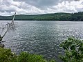
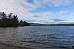
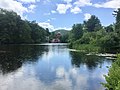
Pemigewasset Lake is a 249-acre (101 ha) water body located in the Lakes Region of central New Hampshire in the United States. The lake straddles the...
3 KB (279 words) - 13:43, 25 August 2022

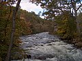
The Pemigewasset River /ˌpɛmɪdʒəˈwɑːsɪt/, known locally as "The Pemi", is a river in the state of New Hampshire, the United States. It is 65.0 miles (104...
8 KB (410 words) - 16:10, 10 May 2024

Lovell Lake Merrymeeting Lake Mirror Lake Newfound Lake Opechee Bay Ossipee Lake Paugus Bay Pemigewasset Lake Pine River Pond Province Lake Silver Lake Squam...
6 KB (383 words) - 20:10, 28 May 2022
into the Pemigewasset at Ashland. Covering 6,791 acres (27.48 km2), Squam is the second-largest lake located entirely in New Hampshire. Squam Lake was originally...
7 KB (638 words) - 00:03, 20 July 2024
is a list of lakes and ponds in the U.S. state of New Hampshire. The New Hampshire Department of Environmental Services lists 944 lakes and impoundments...
14 KB (123 words) - 01:30, 17 December 2023

shore. The lake lies in the Merrimack River watershed. Its outlet, Cascade Brook, flows south over ledges and waterfalls to the Pemigewasset River near...
4 KB (236 words) - 14:02, 22 December 2023
Little Squam Lake, on the Squam River, a tributary of the Pemigewasset River. New Hampshire portal List of lakes in New Hampshire Squam Lakes Association...
2 KB (107 words) - 20:41, 26 December 2023

into the Winnipesaukee River. The latter flows west from the lake and joins the Pemigewasset River in Franklin to form the Merrimack River, which flows...
29 KB (3,293 words) - 14:38, 19 March 2024

the Newfound River, flowing through Bristol village into the Pemigewasset River. The lake volume is 98 billion gallons of water. Wellington State Park...
12 KB (1,350 words) - 06:10, 2 July 2024

bounded on the west and southwest by the Pemigewasset River. Pemigewasset Lake is in the center, and Winona Lake and Lake Waukewan are in the northeast. The...
15 KB (1,175 words) - 17:00, 3 May 2024
Lake flows to the Pemigewasset River shortly above its confluence with the Winnipesaukee River to form the Merrimack. Webster Lake has two public beaches...
2 KB (153 words) - 13:00, 3 July 2024

which collapsed in 2003. The lake is near the height of land in Franconia Notch; the lake's outlet is the Pemigewasset River, which flows south to the...
3 KB (173 words) - 23:11, 8 August 2022

High Huts of the White Mountains (redirect from Lonesome Lake Hut)
from south to north. Lonesome Lake Hut (44°08′19″N 71°42′12″W / 44.1385°N 71.7033°W / 44.1385; -71.7033 (Lonesome Lake Hut)) is the second lowest hut...
17 KB (1,888 words) - 02:01, 4 January 2024

wintertime (as the lake froze). Lake Winnipesaukee Champlain Sea Lake Albany Lake Hitchcock Lake Stowe Information on the Pemigewasset River Archived 2012-07-30...
2 KB (132 words) - 18:02, 2 June 2023
Meredith, New Hampshire (category Populated places on Lake Winnipesaukee)
the town. Several smaller lakes lie between Winnipesaukee and Winnisquam, including Wickwas Lake and Pemigewasset Lake. Lake Waukewan forms the western...
24 KB (1,833 words) - 15:16, 9 June 2024
lake in the White Mountain National Forest.[citation needed] Water from Stinson Lake flows via Stinson Brook, the Baker River, and the Pemigewasset River...
4 KB (333 words) - 16:18, 12 July 2022

river that connects Lake Winnipesaukee with the Pemigewasset and Merrimack rivers in Franklin, New Hampshire. The river is in the Lakes Region of central...
6 KB (354 words) - 13:46, 25 August 2022
Brook Lost River East Branch Pemigewasset River North Fork East Branch Pemigewasset River Winnipesaukee River Tioga River Lake Winnipesaukee Red Hill River...
16 KB (1,292 words) - 16:33, 8 November 2021

Davis brooks to the Fowler River, then via Newfound Lake and the Newfound River to the Pemigewasset. Atwell Brook flows off a northeastern ridge of the...
6 KB (592 words) - 15:37, 11 July 2022
tributary of the Pemigewasset River, part of the Merrimack River watershed. The Newfound River begins at the outlet of Newfound Lake in Bristol, New Hampshire...
3 KB (103 words) - 23:29, 12 July 2022
river is the outlet of Squam Lake, the second-largest lake in New Hampshire, and it is a tributary of the Pemigewasset River, which itself is a tributary...
4 KB (232 words) - 13:35, 25 August 2022

of land, Profile Lake lies beneath the cliff that once held the Old Man of the Mountain. Profile Lake is the source of the Pemigewasset River, the primary...
4 KB (382 words) - 08:22, 17 January 2024

beings Mount Pemigewasset, another New Hampshire rock formation Pareidolia Cydonia, location of the "Face on Mars" Old Man of the Lake Profile Rock Russell...
25 KB (2,624 words) - 15:33, 18 May 2024

school. The Squam Lakes were a trade route for Abenaki Indians and early European settlers, who traveled the Squam River to the Pemigewasset River, then to...
17 KB (1,423 words) - 14:30, 3 May 2024

includes the village of West Franklin. Situated at the confluence of the Pemigewasset and Winnipesaukee rivers that form the Merrimack River, the town was...
16 KB (1,212 words) - 21:00, 14 March 2024

White Oak Pond (category Lakes of Grafton County, New Hampshire)
flows north to Squam Lake and is part of the Pemigewasset River watershed. New Hampshire portal List of lakes in New Hampshire "White Oak Pond, Holderness"...
2 KB (72 words) - 06:10, 23 October 2023

and eventually to Mount Katahdin in Maine. Beneath a waterfall in the Pemigewasset River is a granite pothole about 20 feet (6 m) across known simply as...
8 KB (697 words) - 22:14, 1 August 2023

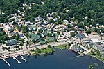
NH Labor Market Area. Plymouth is located at the confluence of the Pemigewasset and Baker rivers and sits at the foot of the White Mountains. The town's...
23 KB (1,545 words) - 12:27, 21 June 2024

the town. Franconia is drained by the Pemigewasset River, the Franconia Branch of the East Branch Pemigewasset River, the Gale River, and the Ham Branch...
15 KB (1,350 words) - 14:26, 3 May 2024

The west part drains into the East Branch Pemigewasset River and Mad River, thence into the Pemigewasset, Merrimack and into the sea at Newburyport,...
6 KB (447 words) - 15:12, 3 July 2023