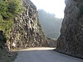
The Pir Panjal Pass, also called Peer Ki Gali (or Peer Gali), is a mountain pass and a tourist destination located in the Pir Panjal Range in Jammu and...
14 KB (1,345 words) - 14:15, 14 June 2024

The Pir Panjal Range (Urdu pronunciation: [piːɾ pənd͡ʒːɑːl] ; Kashmiri pronunciation: [piːr pãːt͡saːl] pronunciation) is a range of mountains in the Lower...
13 KB (1,119 words) - 14:52, 15 July 2024

Mughal Road (redirect from Mughal pass)
used in the Mughal period over the Pir Panjal Pass, at an altitude of 3,500 m (11,500 ft), higher than the Banihal pass at 2,832 m (9,291 ft). The road connects...
8 KB (714 words) - 02:56, 21 June 2024

Indian Himalayan Region (section Pir Panjal Range)
range. Important passes include the Banihal pass, the Pir Panjal pass, the Sinthan pass and the Rohtang pass. To the south of the Pir Panjal lies the Dhauladhar...
7 KB (790 words) - 17:36, 19 May 2024

mountain pass (elevation 3,980 m (13,058 ft)) on the eastern end of the Pir Panjal Range of the Himalayas around 51 km (32 mi) from Manali in the Indian...
9 KB (951 words) - 09:42, 2 July 2024
The Pir Panjal Region (also Pir Panjal Valley)is a region located in the southwestern part of the Pir Panjal Range in the Jammu Division of the Indian-administered...
14 KB (899 words) - 11:57, 1 June 2024

Banihal-Qazigund Railway Tunnel (redirect from Pir Panjal Railway Tunnel)
Banihal-Qazigund Railway Tunnel or Pir Panjal railway tunnel is an 11.215 kilometres (6.969 mi) long railway tunnel located in Pir Panjal Range of middle Himalayas...
6 KB (550 words) - 11:44, 30 July 2023

Tosa Maidan (redirect from Tosa Maidan Pass)
Maidan meadow is situated about 25 km (16 mi) from Khag at the foot of the Pir Panjal range. After crossing the upper mountain reaches of Habber, Drang, Sitaharan...
22 KB (1,687 words) - 16:56, 8 August 2024

surrounded by ranges of the Himalayas, bounded on the southwest by the Pir Panjal Range and on the northeast by the Greater Himalayan range. It is approximately...
11 KB (1,098 words) - 09:17, 23 March 2024

Banihal Pass (Hindi: बनिहाल दर्रा, Urdu: بانہال درا) is a mountain pass across the Pir Panjal Range in India at a maximum elevation of 2,832 m (9,291 ft)...
2 KB (245 words) - 10:01, 11 January 2024
Munawar Pass is a 3,600 metres (11,800 ft) high mountain pass located in Pir Panjal Range in Indian Kashmir. It lies in the north of Pir ki Gali and overlooks...
2 KB (187 words) - 07:29, 4 June 2024
This is a list of mountain passes of India. List of mountains in India List of mountain passes List of Indian states and union territories by highest...
15 KB (52 words) - 14:10, 10 June 2024

Sach Pass is a 4,414-metre-high (14,482 ft) mountain pass in Chamba District, Himachal Pradesh, India on the Pir Panjal range of the Himalayas. It is 127 km...
4 KB (391 words) - 12:35, 1 July 2024

Bahramgala below Pir Panjal Pass (Peer Ki Gali) in the Poonch district. It is at a distance of 10 km from Bufliaz. The Mughal Road passes next to it. This...
4 KB (254 words) - 17:23, 22 November 2022

Hirpora village, east by Rupri, south by Saransar and to the west by the Pir Panjal pass. The slopes are gentle to moderately steep on the eastern aspect and...
7 KB (632 words) - 18:13, 30 November 2022

the rest of Jammu Division and India beyond. The Mughal Road via the Pir Panjal Pass connects Poonch to the Kashmir Valley. There is no rail connectivity...
14 KB (1,292 words) - 02:21, 24 July 2024
routes through the Pir Panjal Range and into Kashmir. However the Durrani Empire kept de facto control of the areas because the Pir Panjal Range blocked supplies...
11 KB (1,266 words) - 22:00, 26 June 2024
the Valley in 1823, about 500 emigrants accompanied him across the Pir Panjal Pass. The 1833 famine resulted in many people leaving the Kashmir Valley...
23 KB (2,690 words) - 14:50, 29 July 2024

Hari Singh Nalwa (section Jamrud (Khyber Pass) (1836))
assistance in navigating the 'Behram Pass' (the lower end of the Pir Panjal Pass). Once the Sikh forces reached the Behram Pass, the Durrani-appointed faujdar...
68 KB (7,916 words) - 02:18, 16 August 2024
the Valley in 1823, about 500 emigrants accompanied him across the Pir Panjal Pass. The 1833 famine resulted in many people leaving the Kashmir Valley...
30 KB (3,122 words) - 10:49, 28 July 2024
four hours. Jawahar Tunnel Banihal Qazigund Road Tunnel Nandni tunnels Pir Panjal Railway Tunnel Zoji-la Tunnel Z-Morh Tunnel Atal Tunnel "Chattergala tunnel...
3 KB (191 words) - 01:56, 22 April 2024
Banihal (redirect from Banhal pass)
meaning the abode of the gods. Banihal Pass is a mountain pass. At 2,832 m (9,291 ft) elevation, the Pir Panjal mountains connect Banihal with Qazigund...
23 KB (2,343 words) - 07:28, 25 July 2024
Nalwa. The contingent under Ram Dayal was ordered to march to the Pir Panjal Pass, while Ranjit Singh led his own contingent to march on the Tosa Maidan...
10 KB (1,239 words) - 05:57, 9 August 2024

Valley used to come up from Bhimber, and pass through the Naushera and Rajouri towns to the Pir Panjal Pass. This is now cut off by the Line of Control...
36 KB (3,186 words) - 17:59, 17 August 2024

situated at a height of 2,600 metres (8,500 ft), right at the base of Pir Panjal Range in the Chamba Valley. It is an ancient temple dedicated to Devi...
5 KB (729 words) - 17:42, 13 December 2023
stalled here centuries ago, forcing the Mughals to retreat over the Pir Panjal Pass. This tradition instilled a superstitious belief among the locals that...
40 KB (4,907 words) - 05:22, 6 August 2024

Himachal Pradesh, India. Then, running north, it passes through Bada Bhangal, joins the PIr Panjal Range and moves into Chamba.[citation needed] The...
8 KB (939 words) - 13:30, 13 August 2024

Union Territory of Jammu and Kashmir in India below the Banihal Pass in the Pir Panjal mountain range in lower Himalayas. It was named after Jawaharlal...
7 KB (711 words) - 13:15, 9 March 2024
Union Territory of Jammu and Kashmir in India, below the Banihal Pass in the Pir Panjal mountain range in lower Himalayas, on National Highway 44. Its construction...
8 KB (766 words) - 00:05, 18 April 2024

Tibet. Included within the Western Himalayas are the Zanskar Range, the Pir Panjal Range, and the Dhauladhar Range, and western parts of the Sivalik Range...
5 KB (513 words) - 06:50, 1 August 2024