
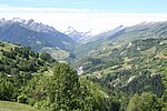
Piz Terri is a mountain in the Lepontine Alps, located on the border between the cantons of Ticino and Graubünden. At 3,149 metres above sea level it...
3 KB (209 words) - 02:50, 5 May 2022
Piz Scharboda is a mountain of the Swiss Lepontine Alps, overlooking the lake of Zervreila in the canton of Graubünden. It lies south of Piz Terri, near...
1 KB (57 words) - 23:08, 16 May 2022
located on the chain between the Val Sumvitg and the Lumnezia, north of Piz Terri. On its southern flank lies a large named Laghet la Greina (2,585 m)....
1 KB (74 words) - 07:37, 12 February 2024

(3,161 m) Piz di Pian (3,158 m) Zapporthorn (3,152 m) Piz Terri (3,149 m) Fanellhorn (3,124 m) Piz Scharboda (3,122 m) Pizzo Ferré (3,103 m) Bruschghorn...
9 KB (805 words) - 19:59, 26 August 2024

is located at a height of 1,606 meters above sea level. The highest is Piz Terri (3,149 m), on the north-east side of the lake, followed by the Plattenberg...
4 KB (356 words) - 01:37, 17 April 2024

in the canton of Ticino. The pass lies between the Piz Medel on the north and Pizzo Marumo, Piz Terri on the south. Greina is also a high plateau (Plaun...
2 KB (157 words) - 18:51, 21 April 2022

over Passo del Lucomagno (1,915 m), across Scopi (3,200 m), Piz Medel (3,210 m) and Piz Terri (3,149 m), where it turns towards the south to the Rheinwaldhorn...
12 KB (1,854 words) - 02:50, 9 August 2024

Täschhorn (Dom), Wetterhorn (Mittelhorn), Piz d'Err (Piz Calderas), Piz Badile (Piz Cengalo), Piz Palü (Piz Zupo), Similaun (Hintere Schwarze), Crozzon...
109 KB (1,721 words) - 18:05, 9 July 2024
the valley, connecting the Lumnezia to the Obersaxen ski area. Piz Terri Piz Aul Piz Mundaun Glenner Gorge Alpine Forests Lake Kar The Chapel of St....
33 KB (3,468 words) - 14:03, 9 August 2024

de Cheilon (Ruinette), Nadelhorn and Täschhorn (Dom), Piz Badile (Piz Cengalo) and Piz Palü (Piz Zupò). For this reason, additional country-wide lists...
112 KB (1,337 words) - 21:15, 20 July 2024

Graubünden 2594 6.00 Piz Ela 3339 Rhine Distelsee Valais 2587 4.95 Ritzberge 2862 Rhone Laghet la Greina Graubünden 2585 18.78 Piz Terri 3149 Rhine Trützisee...
26 KB (243 words) - 10:57, 23 June 2024

in 1793, the Piz Urlaun (11,060 ft), near the Todi; in 1801, Piz Aul (10,250 ft) and Piz Scharboda (10,250 ft); and in 1802, Piz Terri (10,338 ft), these...
4 KB (454 words) - 13:38, 16 March 2023

Cervandone) 3,213 10,542 Piz Medel 3,203 10,509 Scopi 3,200 10,499 Pizzo Rotondo 3,197 10,489 Hohsandhorn 3,182 10,440 Piz Terri 3,151 10,331 Pizzo di Cassimoi...
13 KB (446 words) - 20:29, 23 July 2024

Piz Sezner (2,310 m) is a mountain of the Swiss Lepontine Alps, overlooking Obersaxen in the canton of Graubünden. It is located between the main Rhine...
1 KB (85 words) - 14:52, 2 August 2024

the Tieralplistock The lowest col between equally high Gletscherhorn and Piz Gallagiun is the 383 m deep Passo de la Prasgnola. They share the 2694 m...
55 KB (359 words) - 18:05, 9 July 2024
Highest point Elevation 3,043 m (9,984 ft) Prominence 247 m (810 ft) Parent peak Piz Terri Coordinates 46°33′45″N 9°1′37″E / 46.56250°N 9.02694°E / 46.56250;...
1 KB (71 words) - 22:29, 3 May 2022
09°05′13″E / 46.44389°N 9.08694°E / 46.44389; 9.08694 Lepontine Alps Blenio Piz Terri 3149 390 46°36′00″N 09°02′03″E / 46.60000°N 9.03417°E / 46.60000; 9...
10 KB (296 words) - 00:45, 22 June 2023

Cities Ilanz Physical characteristics Source • location Alp Scharboda, Piz Terri • coordinates 46°36′7″N 9°4′8″E / 46.60194°N 9.06889°E / 46.60194;...
2 KB (129 words) - 07:53, 8 April 2023

metres. Topographically, the most important summit of the canton is that of Piz Bernina (most elevated, most prominent and most isolated). Outside the Bernina...
27 KB (336 words) - 16:08, 5 May 2024

Archived from the original on 6 March 2007. Retrieved 16 March 2007. "Platt, 'Piz' Pluck Pilot Parts". Zap2it.com. Archived from the original on 22 May 2011...
62 KB (7,066 words) - 19:00, 4 September 2024
fieldwork was inspired by his passion for mountains where he climbed Mont Blanc, Piz Badile, Finsteraarhorn, Half Dome, Mt. Shasta, Kilimanjaro, Fujiyama, Kinabalu...
8 KB (1,018 words) - 22:59, 6 October 2023
Bradford Washburn The Ascent of Mt. St. Agnes AAJ Vol. 3 p. 255 (1939) Terris Moore Mt. Stanford: A Alaskan Ski Climb AAJ Vol. 3 p. 265 (1939) Kirill...
143 KB (3,887 words) - 20:10, 23 July 2024

they joined two local guides—Christian Zippert and Johann Piaz—to climb Piz Bernina (4,048.6 m / 13,283 ft). Kaufmann had several significant alpine...
35 KB (4,973 words) - 14:01, 8 August 2024
specimen of Eusaurosphargis dalsassoi from the Anisian (Middle Triassic) of Piz da Peres (Dolomites, northern Italy)". Rivista Italiana di Paleontologia...
106 KB (10,076 words) - 08:02, 20 August 2024