
Piz Toissa is a mountain of the Oberhalbstein Alps, located west of Salouf in the canton of Graubünden. Piz Toissa and Ziteil from Piz Curvér Climb to...
2 KB (68 words) - 23:01, 1 May 2022

located at a height of 2,429 metres above sea level, between Piz Curvér and Piz Toissa, in the canton of Graubünden. It is claimed to be the highest...
2 KB (178 words) - 14:53, 22 August 2024

de Cheilon (Ruinette), Nadelhorn and Täschhorn (Dom), Piz Badile (Piz Cengalo) and Piz Palü (Piz Zupò). For this reason, additional country-wide lists...
112 KB (1,337 words) - 21:15, 20 July 2024
Piz Curvér is a mountain of the Oberhalbstein Range, between Andeer and Savognin, in the canton of Graubünden. With a height of 2,972 metres (9,751 ft)...
1 KB (77 words) - 22:12, 22 December 2022
I/B-09.V-B V-C-O IT 903 Piz Toissa 2657 310 46°37′07″N 09°31′30″E / 46.61861°N 9.52500°E / 46.61861; 9.52500 (903. Piz Toissa (2657 m)) Oberhalbstein...
94 KB (827 words) - 18:10, 4 August 2024

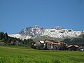
the Albula district. The village lies on a ledge on the east side of Piz Toissa (2,657 meters (8,717 ft)). It consists of the village of Salouf and the...
8 KB (775 words) - 12:36, 8 May 2024

metres. Topographically, the most important summit of the canton is that of Piz Bernina (most elevated, most prominent and most isolated). Outside the Bernina...
27 KB (336 words) - 16:08, 5 May 2024