
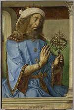
The Ptolemy world map is a map of the world known to Greco-Roman societies in the 2nd century. It is based on the description contained in Ptolemy's book...
7 KB (730 words) - 14:11, 26 May 2024

Ptolemy's map of Ireland is a part of Ptolemy's "first European map" (depicting the British Isles) in the series of maps included in his Geography, which...
22 KB (1,897 words) - 14:17, 4 June 2024
the Roman era, with Ptolemy's world map (2nd century CE), which would remain authoritative throughout the Middle Ages. Since Ptolemy, knowledge of the approximate...
74 KB (8,677 words) - 02:07, 19 August 2024

from an earlier map, although this could not have been an exact copy of Ptolemy's work: his Prime Meridian was 10° east of Ptolemy's, he adds some places...
56 KB (5,415 words) - 01:10, 13 September 2024
Cartography of Europe (redirect from Map of italy)
Mediterranean, an arrangement that was adhered to in medieval T and O maps. Ptolemy's world map of the 2nd century already had a reasonably precise description...
2 KB (229 words) - 09:51, 7 August 2024

Cartography of Africa (redirect from Map of africa)
Catabathmus Magnus (the escarpment of Akabah el-Kebir in western Egypt). Ptolemy's world map (2nd century) shows a reasonable awareness of the general topography...
4 KB (419 words) - 05:26, 5 August 2024
7 – Ptolemy Cluster, star cluster described by Ptolemaeus Pei Xiu Ptolemy's Canon – a dated list of kings used by ancient astronomers. Ptolemy's table...
76 KB (8,113 words) - 19:57, 4 September 2024
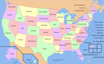
Cartography of the United States (redirect from Map of florida)
States is the history of surveying and creation of maps of the United States. Maps of the New World had been produced since the 16th century. The history...
2 KB (176 words) - 23:29, 9 September 2024
exist) Map of Maximus Planudes (c. 1300), earliest extant realization of Ptolemy's world map (2nd century) Gangnido (Korea, 1402) Bianco world map (1436)...
4 KB (372 words) - 23:00, 5 December 2022
Ptolemy's world map, on which the geographic knowledge of medieval Europe was founded, displays the oceans as separated from each other, with Ptolemy...
7 KB (788 words) - 22:27, 7 August 2024

Cantino planisphere (redirect from Cantino World Map)
The Cantino planisphere or Cantino world map is a manuscript Portuguese world map preserved at the Biblioteca Estense in Modena, Italy. It is named after...
18 KB (2,421 words) - 23:40, 5 July 2024

The map of Juan de la Cosa is a world map that includes the earliest known representation of the New World and the first depiction of the equator and the...
10 KB (1,179 words) - 00:47, 26 August 2024

topological map is a type of diagram that has been simplified so that only vital information remains and unnecessary detail has been removed. These maps lack...
2 KB (133 words) - 21:06, 12 October 2023

Cartography (redirect from Map making)
wrote his treatise on cartography, Geographia. This contained Ptolemy's world map – the world then known to Western society (Ecumene). As early as the 8th...
61 KB (7,317 words) - 01:34, 31 August 2024

Chittagong (section World War II)
the world's oldest ports with a functional natural harbor for centuries, Chittagong appeared on ancient Greek and Roman maps, including on Ptolemy's world...
112 KB (10,265 words) - 18:44, 9 September 2024
Dragons History of cartography Old World, consists of Africa, Europe, and Asia Ptolemy's world map, a map of the world known to Hellenistic society in the...
937 bytes (169 words) - 00:48, 22 April 2023

Chernobyl (section Identity of Ptolemy's "Azagarium")
Eastern Europe mention "Czernobol" (Chernobyl) with reference to Ptolemy's world map (2nd century AD). Czernobol is identified as Azagarium [uk] "oppidium...
44 KB (3,884 words) - 21:52, 26 August 2024

Nicolaus Germanus (section Ptolemy's Geographia)
was a German cartographer who modernized Ptolemy's Geography by applying new projections, adding additional maps, and contributing other innovations that...
9 KB (994 words) - 18:13, 29 June 2024

bestowed in honor of the Italian Amerigo Vespucci. The map is drafted on a modification of Ptolemy's second projection, expanded to accommodate the Americas...
51 KB (7,080 words) - 02:22, 6 July 2024

History of cartography (redirect from World's oldest map)
provided the underpinnings of Ptolemy's influential Geographia. Marinus's geographical treatise is lost and known only from Ptolemy's remarks. He introduced...
143 KB (17,608 words) - 16:47, 22 August 2024
History of Chittagong (section World War II)
the world's oldest ports with a functional natural harbor for centuries, Chittagong appeared on ancient Greek and Roman maps, including on Ptolemy's world...
33 KB (4,015 words) - 00:37, 6 September 2024
Agathodaemon of Alexandria (category Ptolemy)
projection—which Ptolemy disparages—rather than either of Ptolemy's; the world map is done according to the less-favored of the two projections Ptolemy offers....
8 KB (812 words) - 00:48, 21 March 2024

first became a chain of freshwater lakes and marshes, as shown by Ptolemy's world map, then it became extinct about 2000 years ago.: 28 Abundant prehistoric...
3 KB (283 words) - 05:19, 16 July 2024

with the world map. Lucio Russo has speculated about a probable arrival of Phoenicians in the Americas in his philologic analyses of Ptolemy's Geography...
15 KB (1,790 words) - 00:02, 16 June 2024

theorem, and Ptolemy's relation obviously holds. More generally, if the quadrilateral is a rectangle with sides a and b and diagonal d then Ptolemy's theorem...
27 KB (4,921 words) - 14:24, 2 July 2024

The "Old World" (Latin: Mundus Vetus) is a term for Afro-Eurasia that originated in Europe after 1493, when Europeans became aware of the existence of...
5 KB (391 words) - 18:21, 30 August 2024

Catalan Atlas (category Historic maps of the world)
(Catalan: Atles català, Eastern Catalan: [ˈatləs kətəˈla]) is a medieval world map, or mappa mundi, probably created in the late 1370s or the early 1380s...
34 KB (3,079 words) - 17:45, 22 July 2024

- still Greek speaking - colonists on the island once settled by the Ptolemies. In 880, an Ethiopian expeditionary force conquered the island and an...
23 KB (2,704 words) - 10:46, 1 September 2024

the world's oldest ports with a functional natural harbor for centuries, Chittagong appeared on ancient Greek and Roman maps, including on Ptolemy's world...
8 KB (435 words) - 07:08, 23 June 2024

Martin Waldseemüller (section 1507 world map)
first to create a printed wall map of Europe. A set of his maps printed as an appendix to the 1513 edition of Ptolemy's Geography is considered to be the...
15 KB (1,842 words) - 01:08, 8 June 2024