
Porarari River. To the south of the village is Dolomite Point, site of the Pancake Rocks, and Razorback Point at the mouth of the Punakaiki River. A feature...
27 KB (2,673 words) - 20:52, 19 July 2024

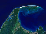
The Punakaiki River is a river of the West Coast Region of New Zealand's South Island. It flows predominantly northwest from its sources in the Paparoa...
3 KB (153 words) - 22:09, 14 July 2024

full length of the trail commences at the Punakaiki River in the south, and ends at the mouth of the Fox River in the north. It takes two or three days...
13 KB (1,244 words) - 21:51, 14 July 2024

sections along the Inangahua River. The park covers the catchment areas of the Punakaiki, Pororari and Fox (Potikohua) rivers and Bullock Creek (Punungairo)...
26 KB (2,405 words) - 22:03, 14 July 2024

an 8 km (5.0 mi) wide strip between Barrytown and Punakaiki, specifically from the Punakaiki River to Waiwhero (Lawson) Creek. The area of the breeding...
26 KB (3,318 words) - 06:28, 12 January 2024

Coast of the South Island. It stretches from the south banks of the Punakaiki River in the north, southeast to Mt Anderson, north to The Pinacle, southeast...
12 KB (903 words) - 06:33, 4 October 2024

Paparoa Track (section Pororari Hut to Punakaiki)
standard be constructed that linked the Pike River Mine site on the eastern side of the Paparoa Range with Punakaiki on the West Coast. This was to serve as...
22 KB (2,195 words) - 11:25, 1 September 2024
Pūerua River Puhi Puhi River Puhoi River Pukaki River Pūkio Stream Punakaiki River Punakitere River Pungapunga River Puniu River Pupuke River Purakaunui...
31 KB (2,843 words) - 05:08, 4 May 2024

(16 mi) length of the trail goes between the Punakaiki River in the south, and the mouth of the Fox River in the north. It takes two or three days to complete...
10 KB (755 words) - 22:06, 14 July 2024

reserve does not include two inshore areas around the Pororari River beach and Punakaiki River beach. Within the reserve there are natural examples of six...
10 KB (917 words) - 22:03, 14 July 2024

Sea at Punakaiki via Pororari Lagoon. Cave Creek / Kotihotiho is a tributary to the river. There are opportunities to tramp along this river, with two...
8 KB (673 words) - 22:09, 14 July 2024

ISBN 978-0-12-812493-2. "Nile River Glow Worm Caves & Punakaiki - New Zealand Trails". newzealandtrails.com. Retrieved 24 July 2022. "Nile River Rainforest Train"...
9 KB (791 words) - 22:10, 14 July 2024
runs from Blackball to the east of the Paparoa Range north and west to Punakaiki on the West Coast. The track is New Zealand's latest "Great Walk". At...
40 KB (4,457 words) - 22:59, 19 July 2024

Coast, Otago Pancake Rocks, Punakaiki Putangirua Pinnacles, Wairarapa Stony Batter, Waiheke Island Truman Track Beach, Punakaiki Horeke basalts, Hokianga...
22 KB (1,736 words) - 12:08, 30 September 2024
Pleasant Point Port Chalmers Port Levy Portobello Pounawea Pukekura Pukeuri Punakaiki Pūponga Queenstown Raes Junction Rai Valley Rakahouka Rakaia Ranfurly...
9 KB (408 words) - 09:17, 17 March 2024
September 2022. "Devoli shines in Contact Energy interim reporting". Punakaiki Fund. 3 March 2021. Retrieved 18 September 2022. "Contact to build Tauhara...
15 KB (1,067 words) - 07:11, 8 July 2024

Bluff, and their northern end by Razorback Point and the mouth of the Punakaiki River.[citation needed] This coastal plain is mostly below 10 metres (33 ft)...
16 KB (1,753 words) - 21:54, 14 July 2024

occurred down to sea level, where suitable steep and rocky terrain (such as Punakaiki on the west coast and Central Otago) existed. Their distributions in coastal...
73 KB (7,890 words) - 15:17, 26 September 2024
Puhoi Pukekohe* Pukehina Pukepoto Pukerimu Pukerua Bay Puketona Pukeuri Punakaiki Purua Putāruru* Putorino Queenstown* Raetihi* Raglan* Rahotu Rai Valley...
15 KB (942 words) - 19:15, 12 August 2024

between Westport and Greymouth. It includes the celebrated Pancake Rocks at Punakaiki. Arthur's Pass National Park (1,144 km2, established 1929) A rugged and...
43 KB (3,127 words) - 20:16, 11 July 2024

the Tongariro River. Full details of these pools, many of which are little more than widenings of the river or clear areas of the river's delta marshes...
165 KB (1,030 words) - 11:24, 29 September 2024

Geography of New Zealand (section Rivers and lakes)
in the Tasman District. Other notable locations are on the West Coast (Punakaiki), Hawke's Bay and Fiordland. Lava caves (lava tubes) usually form in pāhoehoe...
83 KB (7,745 words) - 16:07, 18 September 2024
sharply south at the Paparoa Range before hitting the coast just south of Punakaiki. The main population centres in this configuration were Greymouth and...
8 KB (658 words) - 21:59, 14 July 2024

Franz Josef Glaciers, Hokitika Gorge, Lake Brunner, the Pancake Rocks at Punakaiki, the Oparara Arches and the Heaphy Track. The region has very high rainfall...
29 KB (2,318 words) - 06:05, 4 October 2024

Bullock Creek (New Zealand) (category Rivers of the West Coast Region)
Bullock Creek or Punungairo is a river valley in the Paparoa National Park, located just north of Punakaiki on the West Coast of New Zealand. It includes...
15 KB (1,309 words) - 11:56, 13 August 2024
of Inquiry into the collapse of a viewing platform at Cave Creek near Punakaiki on the West Coast. Judge Noble's report, Published: 1995. DOC website...
17 KB (1,617 words) - 17:13, 26 July 2024

Cave Creek / Kotihotiho (category Rivers of New Zealand)
Recreation students from the Tai Poutini Polytechnic at Greymouth and the Punakaiki Field Centre Manager from the Department of Conservation were on a viewing...
6 KB (493 words) - 21:49, 17 June 2024
Parininihi Piopiotahi (Milford Sound) Pohatu / Flea Bay Poor Knights Islands Punakaiki Taipari Roa (Elizabeth Island) Tapuae Taputeranga Taumoana (Five Finger...
37 KB (3,290 words) - 06:08, 28 June 2024
Island between Westport and Greymouth. It includes the Pancake Rocks at Punakaiki. Rakiura National Park 1,400 540 2002 46°54′S 168°7′E / 46.900°S 168...
20 KB (1,155 words) - 12:44, 16 August 2024

in Buller, Nelson, and the West Coast, including the Pancake Rocks at Punakaiki in Oligocene–Early Miocene times (34–15 Ma). It is debated whether all...
52 KB (6,132 words) - 22:55, 27 September 2024