
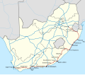
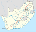
The R62 is a provincial route in South Africa that connects Ashton with Humansdorp. The R62 runs through the Little Karoo and the Langkloof, passing through...
5 KB (373 words) - 19:16, 10 September 2024
R62 may refer to: R62 (New York City Subway car) R62 (South Africa), a road HD 32034, a star HMS Cassandra (R62), a destroyer of the Royal Navy HMS Glory (R62)...
336 bytes (86 words) - 07:09, 10 November 2022
eventually reaches an intersection with the R62 near Ladismith. From this intersection, it is briefly co-signed with the R62 heading east, before again diverging...
2 KB (146 words) - 21:01, 19 September 2024

The R402 is a Regional Route in South Africa that connects the N2 between Stormsrivier and Humansdorp with the R62 between Humansdorp and Joubertina. Routes...
1 KB (61 words) - 20:57, 19 September 2024
South Africa that connects Barrydale to the north with Port Beaufort and Witsand to the south. Originating from the R62 at Barrydale it heads south over...
2 KB (151 words) - 21:01, 19 September 2024

and heads into the Prince Alfred's Pass. On the other side, it meets the R62 at Avontuur at a staggered interchange. It then heads into another pass,...
3 KB (208 words) - 21:01, 19 September 2024

offering the scenic alternative to the N2 highway. Route 62 is named for the R62 provincial route, which it follows from Montagu to Humansdorp, but the tourist...
3 KB (246 words) - 12:09, 28 September 2024
Route in South Africa that connects the N2 at Keurboomsrivier near Plettenberg Bay in the south-east with the R339 (heading to Uniondale and the R62). Routes...
2 KB (68 words) - 21:01, 19 September 2024
intersection with the N12 and R62 and it becomes co-signed with the R62 westwards. Just outside the town, the route diverges from the R62 and continues in a southerly...
3 KB (199 words) - 21:01, 19 September 2024
This is a list of regional routes in South Africa. Route numbers with three digits starting with "R1" are given to sections of road that were formerly...
37 KB (198 words) - 20:50, 19 September 2024

to as major regional routes) are the second category of road in the South African route-numbering scheme. They are designated with the letter "R" followed...
11 KB (248 words) - 14:09, 13 April 2024

the R62, the N9 and N12 split, with the N12 being cosigned with the R62 northwards towards Oudtshoorn while the N9 turns east, cosigned with the R62, to...
5 KB (489 words) - 15:03, 10 September 2024
Valley. The route ends in Montagu at a junction with the R62. Falkner, John (May 2012). South African Numbered Route Description and Destination Analysis (Report)...
2 KB (137 words) - 21:00, 19 September 2024
a gravel road. Its northern origin is from the R62 near Ladismith. From there it winds generally south-east. It goes over Cloete's Pass before reaching...
2 KB (125 words) - 21:01, 19 September 2024

The R60 is a provincial route in Western Cape, South Africa that runs along the Breede River Valley, connecting Worcester with Swellendam via Robertson...
2 KB (77 words) - 19:16, 10 September 2024

junction with the R62 at the northern edge of the Outeniqua Mountains, the N12 splits from the N9 and becomes cosigned with the R62, going north-west...
20 KB (2,097 words) - 15:13, 10 September 2024
Drive - Half Tunnel, Cape Town - M6. Cogmanskloof Tunnel, Western Cape - R62. Hartbeespoort Tunnel, North-West - R104. Hendrik Verwoerd Tunnels, Limpopo...
3 KB (315 words) - 13:51, 14 August 2024

The R61 is a long provincial route in South Africa that connects Beaufort West with Port Shepstone via Graaff-Reinet, Komani (previously Queenstown), Mthatha...
11 KB (1,131 words) - 20:26, 30 September 2024

The R63 is a tarred provincial route in South Africa that connects Calvinia with Komga via Carnarvon, Victoria West, Graaff-Reinet, Somerset East and King...
8 KB (739 words) - 19:17, 10 September 2024
The N2 is a national route in South Africa that runs from Cape Town through George, Gqeberha, East London, Mthatha, Port Shepstone and Durban to Ermelo...
39 KB (4,078 words) - 18:30, 25 September 2024
South Africa portal The N1 is a national route in South Africa that runs from Cape Town through Bloemfontein, Johannesburg, Pretoria and Polokwane to Beit...
32 KB (2,875 words) - 15:01, 10 September 2024
Capitec Bank (category Banks of South Africa)
Bank is a South African retail bank and financial services company. As of February 2024 the bank was the largest retail bank in South Africa, based on...
8 KB (597 words) - 13:40, 26 August 2024

Cogmanskloof Pass (category Use South African English from July 2024)
Cogmanskloof Pass is a mountain pass in Western Cape, South Africa, on the R62 provincial road over the Langeberg between Ashton in the Boland and Montagu...
2 KB (195 words) - 09:36, 4 August 2024

Western Cape province of South Africa. The town is located 13km south-east of Uniondale on an intersection of the R339 and R62 regional routes. The name...
4 KB (109 words) - 09:32, 1 October 2019
Huis River Pass (category South Africa articles missing geocoordinate data)
655 m above sea level and has a maximum gradient of 1:14. It crosses the R62 provincial road over the Huis River Mountains, a spur of the Swartberg. The...
2 KB (171 words) - 09:55, 4 August 2024
Louterwater (category Use South African English from January 2015)
Municipality in the Eastern Cape province of South Africa, located between Joubertina and Misgund on the R62 road. The town hosts a large apple and pear...
4 KB (91 words) - 19:21, 24 March 2019
Kromme Dam (category Dams in South Africa)
usage. Churchill Dam lies east-southeast of Kareedouw, south of the path of the Langkloof Valley (R62 road), and on the northern slopes of the Kareedouw Mountains...
3 KB (290 words) - 07:28, 10 July 2024
Joubertina (category Use South African English from January 2015)
Church in Uniondale between 1878 and 1893. Joubertina is located on the R62 road in the Langkloof valley, approximately 5 km west of Twee Riviere, near...
5 KB (206 words) - 19:52, 24 February 2021
List of mountain passes of the Western Cape (category Lists of landforms of South Africa)
(secondary coordinates) Mountain Passes of South Africa Wild Dog Adventure Riding, South Africa "South Africa Traffic Events". i-TRAFFIC. Retrieved 3 February...
11 KB (55 words) - 07:46, 15 July 2024
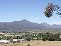
Langkloof (category Valleys of South Africa)
The Langkloof is a 160 km-long (99 mi) valley in South Africa, lying between Herold, a small village northeast of George, and The Heights – just beyond...
4 KB (458 words) - 07:58, 17 July 2024