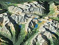
decorations may have influenced the raised-relief map. The Han dynasty general Ma Yuan made a raised-relief map of valleys and mountains in a rice-constructed...
13 KB (1,663 words) - 18:37, 7 October 2023

Terrain cartography (redirect from Relief-Shaded Elevation Map)
Terrain cartography or relief mapping is the depiction of the shape of the surface of the Earth on a map, using one or more of several techniques that...
25 KB (2,876 words) - 16:51, 19 June 2024
Relief map or mapping may refer to: Raised-relief map, a 3D physical representation of terrain Relief mapping (computer graphics), the 3D digital rendering...
363 bytes (75 words) - 00:08, 21 January 2018
a topographic map or topographic sheet is a type of map characterized by large-scale detail and quantitative representation of relief features, usually...
20 KB (2,043 words) - 06:29, 4 September 2024

Shen Kuo (section Raised-relief map)
development of the raised-relief map in China. The Han dynasty general Ma Yuan (14 BC – 49 AD) is recorded as having made a raised-relief map of valleys and...
100 KB (12,176 words) - 19:58, 20 August 2024
contour line; for example, if a plane cuts through mountains of a raised-relief map parallel to the ground, the result is a contour line in two-dimensional...
13 KB (1,737 words) - 01:21, 4 December 2023

Ma Jun were created in later dynasties as well. Raised-relief map (Terrain Model): The raised-relief map may have existed in China since the 3rd century...
272 KB (35,155 words) - 02:25, 21 August 2024
papermaking, rudders for steering ships, negative numbers in mathematics, raised-relief maps, hydraulic-powered armillary spheres for astronomy, and seismometers...
156 KB (17,700 words) - 17:52, 29 August 2024

Vertical exaggeration (VE) is a scale that is used in raised-relief maps, plans and technical drawings (cross section perspectives), in order to emphasize...
3 KB (304 words) - 07:53, 22 August 2024

renovations. The dining room located on the same floor is highlighted by a raised-relief map of the Philippines on its ceiling. Also on this level is the bedroom...
12 KB (1,165 words) - 15:30, 27 June 2024

distances was applied to terrain maps. Following a long tradition, Shen Kuo created a raised-relief map, while his other maps featured a uniform graduated...
114 KB (12,860 words) - 23:46, 17 August 2024
suspension bridge, natural gas as fuel, the magnetic compass, the raised-relief map, the propeller, the crossbow, the south-pointing chariot, and gunpowder...
34 KB (4,165 words) - 07:39, 31 July 2024
Cartography of India (redirect from Map of india)
half feet in breadth, was presented to Warren Hastings. In this raised-relief map the mountains were elevated above the surface and several geographical...
19 KB (2,266 words) - 01:20, 2 June 2024

channel drinking water to residents and visitors. A comprehensive raised-relief map of the system is on display at the Queens Museum of Art. Until the...
28 KB (3,267 words) - 15:14, 25 March 2024

bridge. Relief map of the Philippines. Built in the 1960s and designed by Filipino sculptor Jose M. Mendoza, this was a giant raised-relief map of the...
44 KB (4,704 words) - 12:43, 1 September 2024

historical artifacts and memorabilia relating to the curve and a raised-relief map of the Altoona–Johnstown area. Access to the curve is by a 288-foot...
27 KB (2,850 words) - 00:59, 7 June 2024

gigantic raised-relief map representing the Qin Empire is located within the tomb of Qin Shi Huang, it is known that small raised-relief maps were created...
106 KB (13,890 words) - 08:54, 27 August 2024

early seismological detectors, matches, paper, Helicopter rotor, Raised-relief map, the double-action piston pump, cast iron, water powered blast furnace...
96 KB (11,186 words) - 09:37, 14 August 2024

raised-relief maps of his time, for which he was regarded by geologist G. K. Gilbert as "a pioneer—if not the pioneer—in the United States." His maps...
3 KB (364 words) - 18:49, 25 May 2024

wheelbarrow, the suspension bridge, the parachute, natural gas as fuel, the raised-relief map, the propeller, the sluice gate, and the pound lock. The Tang dynasty...
66 KB (8,328 words) - 12:31, 3 September 2024

History of cartography (redirect from Ancient map)
three maps of China and foreign regions that were drawn at a uniform scale of 1:900,000. Shen also created a three-dimensional raised-relief map using...
143 KB (17,608 words) - 16:47, 22 August 2024

individual exhibitors; the artwork included large murals, sculptures, and reliefs. The structures were painted in about 100 hues, and some of the paint colors...
190 KB (13,280 words) - 14:10, 30 August 2024
The Tube map (sometimes called the London Underground map) is a schematic transport map of the lines, stations and services of the London Underground,...
74 KB (6,231 words) - 07:57, 2 September 2024
wheelbarrow, the suspension bridge, the winnowing machine, gunpowder, the raised-relief map, toilet paper, the efficient harness, along with contributions in...
206 KB (23,241 words) - 13:34, 4 September 2024

Digital elevation model (redirect from Digital elevation map)
Creation of relief maps Rendering of 3D visualizations. 3D flight planning and TERCOM Creation of physical models (including raised relief maps and 3D printed...
30 KB (3,235 words) - 10:40, 4 July 2024
List of cartographers (category Map companies)
atlas of China and foreign regions, and also made a three-dimensional raised-relief map al-Idrisi, Sicily (1100–1166), Arab cartographer, geographer and traveller...
30 KB (3,143 words) - 00:15, 29 August 2024
court mission to inspect a frontier region, Shen Kuo once made a raised-relief map of wood and glue-soaked sawdust to show the mountains, roads, rivers...
78 KB (9,702 words) - 21:13, 22 August 2024

Cartography (redirect from Map making)
component to a map displaying change Cartogram – Map distorting size to show another value Terrain cartography, also known as Cartographic relief depiction –...
61 KB (7,317 words) - 01:34, 31 August 2024

ship to be set in concrete in the midst of a seal pool adjacent to a raised-relief map of California and a series of aquariums. Donations were promised to...
81 KB (8,061 words) - 05:34, 26 August 2024
