Ranges Bridge is a rural locality in the Western Downs Region, Queensland, Australia. In the 2021 census, Ranges Bridge had a population of 98 people...
3 KB (193 words) - 07:48, 29 May 2024

Hervey Range is a rural locality split between the City of Townsville and the Charters Towers Region, Queensland, Australia. In the 2021 census, Hervey...
9 KB (715 words) - 04:52, 24 August 2024

Brisbane (redirect from Brisbane, Queensland)
of Queensland, the Story Bridge and bridge climb; St John's Cathedral, ANZAC Square and the Queensland Cultural Centre (including the Queensland Museum...
208 KB (17,758 words) - 06:17, 11 September 2024

Natural Bridge is a rural locality in the City of Gold Coast, Queensland, Australia. It borders New South Wales. In the 2021 census, Natural Bridge had a...
8 KB (650 words) - 17:44, 25 July 2024

boat or land bridge across Torres Strait, and became divided into over 90 different language groups. During the last ice age, Queensland's landscape became...
121 KB (10,504 words) - 17:42, 11 September 2024

Cairns-to-Kuranda railway line (redirect from Kuranda railway station, Queensland)
It was built from 1913 to 1915 by Queensland Railways. Components of it include Stoney Creek Bridge, the Rail Bridge over Christmas Creek, Kuranda railway...
69 KB (10,284 words) - 19:24, 17 June 2024

September 2024. "Layers: Locality; Mountains and ranges; Contours; Watercourses". Queensland Globe. Queensland Government. Archived from the original on 19...
18 KB (1,608 words) - 21:56, 3 September 2024

of work. In 1931, Hornibrook approached the Queensland Government with a proposal to construct a toll bridge linking the southern part of Redcliffe with...
21 KB (2,338 words) - 07:59, 23 December 2023

Mount Taupiri (redirect from Taupiri Range)
Taupiri Maunga". Stuff. Retrieved 5 September 2024. "The University of Queensland Homepage". Akuhata, Karla (2011-09-26). "Revered Kingitanga elder reunited...
6 KB (699 words) - 12:17, 5 September 2024

Creek Bridge is a heritage-listed road from Mutarnee to Paluma with a bridge over Little Crystal Creek at Crystal Creek, City of Townsville, Queensland, Australia...
29 KB (4,111 words) - 19:45, 2 August 2023

forested mountain ranges – the eastern range now known as Cardwell Range, and the inner Seaview Range. Early in 1864 Dalrymple, with Queensland Government sanction...
8 KB (1,098 words) - 09:58, 14 May 2024
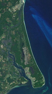
Bribie Island (redirect from Bribie Island, Queensland)
the bridge cost £520,000 and was officially opened on Saturday 19 October 1963 by the Premier of Queensland Frank Nicklin. An additional bridge onto...
44 KB (5,175 words) - 17:00, 19 May 2024

is connected by a bridge over the Pumicestone Passage it is the most developed island in the region. To the north west of Queensland is the Gulf of Carpentaria...
35 KB (3,127 words) - 14:22, 23 August 2024
Logan River (redirect from Logan River, Queensland)
near Jimboomba. In 2006 the Queensland Government decided against the construction of a Logan River dam at Tilley's Bridge in Rathdowney due to mounting...
20 KB (1,810 words) - 00:19, 1 April 2024

Burdekin River (redirect from Cape River (Queensland))
Although replaced by a new bridge in 1964, the old bridge remains and is listed on the Queensland Heritage Register. The townships of Ayr and Brandon...
27 KB (2,755 words) - 21:30, 26 August 2024

Cairns (redirect from Cairns, Queensland, Australia)
Gimuy) is a city in the Cairns Region, Queensland, Australia, on the tropical north east coast of Far North Queensland. In the 2021 census, Cairns had a population...
94 KB (8,752 words) - 12:36, 1 September 2024

The Goodwill Bridge is a pedestrian and cyclist bridge which spans the Brisbane River in Brisbane, Queensland, Australia. The bridge connects the South...
10 KB (974 words) - 16:07, 26 August 2024

Queensland Rail (QR) is a railway operator in Queensland, Australia. Owned by the Queensland Government, it operates local and long-distance passenger...
62 KB (4,207 words) - 07:14, 6 August 2024

Breakfast Creek (redirect from Breakfast Creek, Queensland)
Brisbane in the South East region of Queensland, Australia. Rising as the Enoggera Creek that drains the D'Aguilar Range in the D'Aguilar National Park, Breakfast...
9 KB (705 words) - 02:16, 23 August 2024

Townsville (redirect from Notable persons born in Townsville, Queensland)
north-eastern coast of Queensland, Australia. With a population of 179,011 as of the 2021 census, it is the largest settlement in North Queensland and Northern...
125 KB (11,574 words) - 00:45, 31 August 2024

Brisbane River (redirect from Brisbane River, Queensland)
The Brisbane River (Turrbal: Maiwar) is the longest river in South East Queensland, Australia, and flows through the city of Brisbane, before emptying into...
75 KB (6,851 words) - 04:54, 30 August 2024

Brisbane central business district (redirect from City, Queensland)
suburb and central business district of Brisbane, the state capital of Queensland, Australia. It is also colloquially referred to as the "Brisbane CBD"...
35 KB (3,249 words) - 12:44, 8 August 2024

Ekka (redirect from Queensland Agricultural Show)
The Ekka is the annual agricultural show of Queensland, Australia. Its formal title is the Royal Queensland Show, and it is held at the Brisbane Showgrounds...
18 KB (1,611 words) - 03:26, 20 August 2024

bridges. The immense scale of the Main Range Railway demanded large numbers of skilled and unskilled workers to complete the project. The Queensland Government's...
62 KB (9,375 words) - 21:15, 16 August 2024
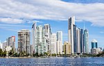
coordinates) Surfers Paradise is a town and suburb in the City of Gold Coast, Queensland, Australia. In the 2021 census, the suburb of Surfers Paradise had a population...
56 KB (5,634 words) - 00:25, 10 July 2024

Gold Coast hinterland (redirect from Gold Coast Hinterlands, Queensland)
East Queensland, Australia that comprises the Tweed Range, Nimmel Range, Tamborine Mountain, Numinbah Valley, eastern parts of the McPherson Range and...
9 KB (892 words) - 01:49, 22 July 2024

May 2009. "Layers: Locality; Mountains and ranges; Contours; Watercourses". Queensland Globe. Queensland Government. Retrieved 12 March 2024. Whitehead...
14 KB (1,172 words) - 04:57, 12 March 2024

major river system in the South East and Wide Bay–Burnett regions of Queensland, Australia. The Mary River is unique in that it flows south to north....
24 KB (2,080 words) - 01:34, 13 August 2024

The Queensland Cultural Centre is a heritage-listed cultural center on Grey Street, South Brisbane, Queensland, Australia. It is part of the South Bank...
71 KB (9,143 words) - 13:19, 28 July 2024

Bruce Highway (redirect from A1 highway (Queensland))
The Bruce Highway is a major highway in Queensland, Australia. Commencing in the state capital, Brisbane, it passes through areas close to the eastern...
103 KB (5,373 words) - 07:55, 6 August 2024