Neckar-Alb is one of three regions (Regionalverband) in the Tübingen administrative region (Regierungsbezirke) in Baden-Württemberg, Germany. It contains...
2 KB (55 words) - 06:00, 16 April 2024
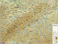
Swabian Jura (redirect from Schwäbische Alb)
and later also electronics and computer industries developed. The "Neckar-Alb" region is the third largest industrial zone in Germany, and the most stable...
20 KB (2,583 words) - 08:42, 20 August 2024

River valley. It is sub-divided into the three regions (Regionalverband): Neckar-Alb, Donau-Iller and Bodensee-Oberschwaben. Donau-Iller also includes three...
4 KB (202 words) - 17:25, 12 March 2024
chief mountains include the Black Forest on the west, the Swabian Alb or Rauhe Alb stretching across the middle of the area from south-west to north-east...
3 KB (457 words) - 20:13, 11 July 2024

ISBN 3-924999-04-X Wolf-Ingo Seidelmann (1988), Der Neckar-Donau-Kanal. 200 Jahre Planung für eine Wasserstrasse quer über die Alb, Beiträge zur südwestdeutschen Wirtschafts-...
82 KB (9,581 words) - 07:37, 20 August 2024

493. ISBN 0-553-59256-4. "Regio-Report Neckar-Alb Aus der Region" (in German). E-Paper - Wirtschaft-Neckar Alb. April 2007. Archived from the original...
3 KB (272 words) - 09:19, 2 June 2024

Tübingen (category Populated places on the Neckar basin)
one of the two centre cities of the Neckar-Alb region. Administratively, it is not part of the Stuttgart Region, bordering it to the north and west (Böblingen...
42 KB (4,700 words) - 07:11, 20 August 2024

of the Swabian Alb known as the Heuberg to the east, and the Randen mountain to the south. The Baar contains the source of the Neckar (a bog in Villingen-Schwenningen)...
3 KB (303 words) - 20:15, 20 August 2024
Topographically the Region lays between 170 m above sea level (Neckar near Kirchheim am Neckar) and 835 m above sea level (swabian albs plateau near Hohenstadt)...
21 KB (2,262 words) - 17:44, 26 July 2024
the Neckar river valley. Its counterpart is Upper Swabia (Oberschwaben), which lies directly to the South by lake Constance and the Swabian Alb. v t...
869 bytes (89 words) - 01:30, 11 October 2023
Göppingen (district) (category Stuttgart (region))
northern foothills of the Swabian Jura (Schwäbische Alb). It is crossed by the Fils, a tributary of the Neckar. The lion is the symbol of the Staufen family...
4 KB (313 words) - 16:47, 25 March 2024

area, e.g., between Upper Swabia, the Swabian Alb, and the central Neckar Valley of the Stuttgart region). In South Baden, the local dialects are Low Alemannic...
74 KB (6,057 words) - 10:26, 20 August 2024
Ostalbkreis (category Stuttgart (region))
located in the eastern part of the Swabian Alb (Schwäbische Alb), hence its name which translates to Eastern Alb District. Main rivers in the district are...
5 KB (346 words) - 18:32, 25 March 2024
Museum of Blaubeuren (Urgeschichtliches Museum Blaubeuren). The Swabian Alb region of Germany has a number of caves that have yielded many mammoth-ivory...
13 KB (1,187 words) - 01:50, 9 August 2024
Esslingen (district) (category Stuttgart (region))
by the river Neckar. The west part is part of the Filder plain, while the east is part of the mountains of the Swabian Alb (Schwäbische Alb) and the Schurwald...
20 KB (2,105 words) - 17:55, 23 March 2024

the time was set up as a Memento. The memorial is a member of the Gäu-Neckar-Alb Memorials Network and the Natzweiler Memorials Network in the former concentration...
6 KB (751 words) - 00:56, 4 January 2022

Verkehrsverbund (reaches into Rhineland-Palatinate) naldo Verkehrsverbund Neckar-Alb-Donau RVF Regio-Verkehrsverbund Freiburg RVL Regio Verkehrsverbund Lörrach...
5 KB (458 words) - 14:41, 24 May 2024

Tübingen–Sigmaringen railway (redirect from Zollern-Alb-Bahn 1)
Station to the west, with some services from Stuttgart running on from the Neckar-Alb Railway, and immediately swings to the south along the valley of Steinlach...
10 KB (1,266 words) - 11:07, 5 August 2023
Rottweil (district) (category Freiburg (region))
district covers part of the mountains of the Black Forest and the Swabian Alb. The Neckar River bisects the district from south to north as it flows towards...
5 KB (393 words) - 19:01, 25 March 2024

Gäu Plateaus (redirect from Neckar- und Taubergäuplatten)
handbook's regional numbers are shown in brackets): Alb-Wutach Region (120) Baar (121) Upper Gäue (122) Neckar Basin (123) Stromberg and Heuchelberg (124) Kraichgau...
5 KB (541 words) - 05:47, 4 January 2021

Hohenzollerische Landesbahn. Sigmaringen lies in the serving area of Verkehrsverbund Neckar-Alb-Donau (NALDO). Fidelis of Sigmaringen (1577-1622), a Roman Catholic Capuchin...
14 KB (1,422 words) - 19:25, 23 May 2024

Römerstein (category Tübingen region geography stubs)
Swabian Alb, in the northeastern corner of the district of Reutlingen. The community is named after the Römerstein, the highest hill of the region at 875...
10 KB (1,264 words) - 17:39, 6 August 2023

the link from Gomaringen to the Schwaebische Alb. Public transport is provided by Verkehrsverbund Neckar-Alb-Donau (NALDO). The town is in comb no. 113...
4 KB (411 words) - 10:55, 10 October 2022

Merklingen - Schwäbische Alb station is a railway station in the municipality of Merklingen, located in the Alb-Donau district in Baden-Württemberg, Germany...
46 KB (4,992 words) - 04:59, 31 July 2024

borders with France and Switzerland. It is the source of the Danube and Neckar rivers. Its highest peak is the Feldberg with an elevation of 1,493 metres...
90 KB (9,716 words) - 06:54, 20 August 2024

Plochingen (category Populated places on the Neckar basin)
Fils and the outflowing Neckar. In the area of the town, three Natural areas collide, the Foreland of the central Swabian Alb in the southeast, the subspace...
20 KB (1,866 words) - 11:44, 12 June 2024

Essingen (Württemberg) (category Stuttgart region geography stubs)
merge with the Neckar near Stuttgart. Essingen currently has about 6000 residents, and is located on the northern end of the Swabian Alb. It is mainly...
3 KB (272 words) - 11:45, 31 October 2022
Bavaria Heuberg (Westerheim), village in the municipality of Westerheim, Alb-Donau-Kreis, Baden-Württemberg in Austria: Heuberg, cadastral municipality...
4 KB (547 words) - 21:57, 24 January 2021

range extends from the Rhine to the Neckar, and is referred to by one of the various names listed depending on the region it is passing through. According...
5 KB (561 words) - 18:09, 15 March 2024
Neckar (Rottenburg Post), Mössingen (Steinlach-Bote) and Reutlingen make up only the part of the daily newspaper that reports on the region of Neckar-Alb...
2 KB (186 words) - 10:37, 18 February 2022