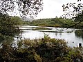
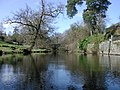
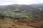
The Brathay is a river of north-west England. Its name comes from Old Norse and means broad river. It rises at a point 1289 feet (393 m) above sea level...
4 KB (438 words) - 22:33, 11 April 2024
Brathay Trust is a youth-development charity with its head office and residential centre based at Brathay in Cumbria, England. Founded in 1946 by Francis...
20 KB (2,043 words) - 19:58, 16 July 2024

Brathay is a parish in Cumbria, England. Brathay Hall and the surrounding estate belong to a charity, Brathay Trust. Cumbria portal Listed buildings in...
1 KB (35 words) - 17:13, 22 August 2021

miles (4.8 km) before merging with the River Brathay at Croft Lodge south-west of Ambleside. From there the rivers flow into the northern end of Windermere...
3 KB (442 words) - 22:53, 26 February 2024

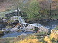
Broughton-in-Furness and Barrow in Furness. Slater's Bridge which crosses the River Brathay in three spans supported by a large mid-stream boulder and stone causeways...
33 KB (3,195 words) - 17:11, 17 January 2024

east bank) River Brathay (combines with Rothay to enter head of Windermere) Great Langdale Beck (L) River Rothay (combines with Brathay to enter head...
87 KB (10,761 words) - 08:18, 16 June 2024
54°25′04″N 3°03′42″W / 54.41783°N 3.06165°W / 54.41783; -3.06165 Crosses River Brathay Locale Little Langdale, Cumbria Statistics Listed Building – Grade II*...
3 KB (298 words) - 01:03, 9 September 2022

Its outflow is the River Brathay, which flows south to join Windermere near Ambleside. Windermere is itself drained by the River Leven, which flows into...
4 KB (300 words) - 18:12, 14 December 2023

the River Rothay flows through Grasmere and Rydal Water before bending around the eastern side of Loughrigg. On the southern flank the River Brathay runs...
6 KB (656 words) - 22:56, 15 April 2024

lake is drained from its southernmost point by the River Leven. It is replenished by the rivers Brathay, Rothay, Trout Beck, Cunsey Beck and several other...
42 KB (4,565 words) - 18:45, 23 June 2024
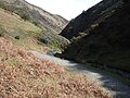
V-shaped valley down which a river with a winding course flows. Each of these spurs extends laterally into a concave bend of the river such that when viewed...
2 KB (267 words) - 07:28, 16 October 2023
Brathay Exploration Trust, formerly Brathay Exploration Group, is a not-for-profit charity in the UK which has been providing worldwide youth expeditions...
5 KB (515 words) - 15:52, 22 February 2020
county of Cumbria, England. Clappersgate is located on the B5286 road and on the River Brathay. It is near the town of Ambleside. english-lakes.com v t e...
2 KB (40 words) - 18:12, 22 August 2021

Cunsey Beck (category England river stubs)
inadequately investigated at the time. Cumbria portal River Brathay River Rothay Trout Beck River Leven Fletcher, Joe (23 June 2022). "'Disaster' as pollution...
3 KB (293 words) - 18:47, 29 March 2024
parent. Black Fell's northern boundary is formed by Elter Water and the River Brathay. The broadleaved woodland of Brow Coppice stands above the village of...
6 KB (809 words) - 21:45, 3 April 2024

Stake Pass descends into Great Langdale. This also descends, via the River Brathay, to Windermere. As the name suggests, the Central Fells are the only...
8 KB (1,090 words) - 18:42, 2 June 2024
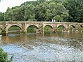
to carry packhorses (horses loaded with sidebags or panniers) across a river or stream. Typically a packhorse bridge consists of one or more narrow (one...
97 KB (4,138 words) - 09:44, 1 May 2024

beds are found in shallow areas (3–12 ft) in either the lake or the River Brathay. In springtime, spawning occurs in the main lake and in deep water (50–70 ft)...
12 KB (1,485 words) - 04:13, 27 April 2024

Langdale. A steep sided, rather marshy valley, Greenburn's waters join the River Brathay at Little Langdale Tarn. Greenburn itself bears a tarn, or more correctly...
7 KB (999 words) - 23:49, 20 April 2024
packhorse bridge crossing River Brathay. From the south side a segmental arch crosses to a natural boulder in the middle of the river. This is in slate, and...
149 KB (4,702 words) - 16:57, 4 June 2024

Greenburn is a part of the Little Langdale system, its waters joining the River Brathay at Little Langdale Tarn. Greenburn itself bears a tarn, or more correctly...
7 KB (1,055 words) - 17:18, 6 April 2024
06165 (Slater's Bridge) 17th century A former packhorse bridge over the River Brathay. In the centre is a large natural boulder, to the south is a segmental...
45 KB (1,339 words) - 20:52, 24 July 2023
National Heritage List for England, retrieved 8 May 2017 Historic England, "Brathay Hall, Skelwith (1087203)", National Heritage List for England, retrieved...
14 KB (516 words) - 04:53, 20 April 2022

Trout Beck (category Rivers of Cumbria)
administrative county of Cumbria. Cumbria portal Cunsey Beck River Leven River Brathay River Rothay "Trout Beck". Catchment Data Explorer. Environment Agency...
5 KB (402 words) - 18:57, 29 March 2024

Cumbrian toponymy (section Rivers)
'dark river' from ON blaengir, blá Brathay 'broad river' from ON breiðr á Calder 'rocky, fast flowing river' from Br *kaleto *dubro Caldew 'cold river' from...
23 KB (2,942 words) - 10:25, 1 May 2024
more than 250m thickness of dark grey mudstones and siltstones of the Brathay Formation which, with the overlying Coldwell and Wray Castle formations...
6 KB (667 words) - 10:40, 15 March 2023

in 2014. In September 2014, the newly refurbished campus was reopened. Brathay Exploration Group, a youth charity, mainly meets at associated Clappersgate...
24 KB (2,153 words) - 10:10, 13 July 2024
last 100 Waorani Indians in Guyana. Narrator Brathay Explores 1x18 min Exploration expeditions of the Brathay Trust from 1948 to 1988. Narrator The New Battle...
115 KB (3,039 words) - 10:48, 25 July 2024

Furness Fells. The inland boundary of the region is formed by the rivers Leven, Brathay and Duddon, and the lake of Windermere. Off the southern tip of...
19 KB (2,391 words) - 01:42, 15 May 2024