
Provincial Route 63 is a 29-kilometre-long (18 mi) Argentine road in the East of Buenos Aires Province. The road extends from Dolores, Buenos Aires to...
7 KB (630 words) - 07:26, 23 August 2024

Provincial Route 6 is a 177 km interurban road (numbered from km 30 to km 210), located on the outer edge of Greater Buenos Aires, in the metropolitan...
8 KB (634 words) - 22:27, 26 August 2022

National Route 7 (Argentina) (category National roads in Buenos Aires Province)
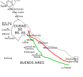
Ruta Nacional 7 Carretera Libertador General San Martín) is a road in Argentina. It crosses the country from east to west, from the capital (Buenos Aires)...
46 KB (5,348 words) - 21:46, 3 January 2024

National Route 9 (Argentina) (redirect from Ruta Nacional 9 (Argentina))
Spanish, Ruta Nacional 9) is a major road in Argentina, which runs from the center-east to the northwest of the country, crossing the provinces of Buenos Aires...
23 KB (2,127 words) - 09:53, 23 July 2024

Provincial Route 11 is a 583-kilometre-long (362 mi) Argentine road in the East of Buenos Aires Province. The road extends from Punta Lara (starting in...
16 KB (1,035 words) - 07:27, 23 August 2024

Fangio (also known as Provincial Route 2, formerly National Route 2) is an Argentine dual carriageway, which runs from Buenos Aires to Mar del Plata. The...
28 KB (2,624 words) - 07:34, 23 August 2024
National Route 1 (Argentina) (redirect from Buenos Aires-La Plata Highway)
connects the 25 de Mayo Highway and Paseo del Bajo in the city of Buenos Aires with the Provincial Route 11, near the city of La Plata. It has a length of 50 km...
11 KB (1,034 words) - 00:59, 5 October 2023

Provincial Route 36 is a 155 km (96 mi) long paved highway located in the eastern province of Buenos Aires, in Argentina, which joins the Matanza River...
2 KB (130 words) - 21:32, 25 February 2023

National Route 3 (Argentina) (redirect from Ruta Nacional 3)
Ruta Nacional 3 ("National Route 3") is an Argentine highway, stretching from the eastern side of the country in Buenos Aires, crossing the provinces...
7 KB (771 words) - 18:38, 11 November 2023

Mar del Plata (category Populated places in Buenos Aires Province)
Ocean, in Buenos Aires Province, Argentina. It is the seat of General Pueyrredón district. Mar del Plata is the second largest city in Buenos Aires Province...
60 KB (5,551 words) - 01:12, 8 September 2024

Avenida General Paz (redirect from Ruta Nacional A001 (Argentina))
General Paz (official name Ruta Nacional A001 - National Route A001) is a beltway freeway surrounding the city of Buenos Aires. Roughly following the boundary...
5 KB (509 words) - 06:33, 25 February 2023

Bahía Blanca (redirect from Bahía Blanca, Buenos Aires)
White Bay) is a city by the Atlantic Ocean, in the southwest province of Buenos Aires, Argentina. It is the seat of government of the Bahía Blanca Partido...
52 KB (5,484 words) - 01:11, 8 September 2024

National Route 40 (Argentina) (redirect from Ruta 40)
National Route 40, also known as RN40 or "Ruta 40", is a route in western Argentina, stretching from Cabo Vírgenes near Río Gallegos in Santa Cruz Province...
10 KB (1,002 words) - 10:38, 24 July 2023
Provincial Route 8 is a 45 km (28 mi) long paved highway located in Greater Buenos Aires, in the northeast of the province of Buenos Aires, in Argentina...
2 KB (107 words) - 01:12, 23 January 2022

largest census metropolitan area in the country. Ruta Nacional 7, the major road running between Buenos Aires and Santiago, runs through Mendoza. The city...
39 KB (2,921 words) - 11:58, 22 September 2024

(PDF) on 27 September 2007. Retrieved 23 March 2008. Rutas Nacionales - Centro Cartográfico Buenos Aires - c. 1975 Cámara de Diputados de la Provincia de...
4 KB (440 words) - 07:21, 8 August 2023

Provincial Route 215 is a 109-kilometre-long (68 mi) highway in the northeast of the Province of Buenos Aires, Argentina that joins the West Channel in...
7 KB (406 words) - 14:18, 24 March 2023

National Route 273 Provincial Route 70 (Santa Fe) Provincial Route 80 (Santa Fe) Provincial Route 210 (Buenos Aires) "Sobre nuestras Rutas". Dirección Nacional...
6 KB (553 words) - 07:13, 12 March 2023

Provincial Route 1 is a 21 km (13 mi) long paved highway located in the partidos of La Plata and Berazategui in the province of Buenos Aires, in Argentina...
2 KB (165 words) - 01:26, 23 January 2022

Néstor Kirchner (category Members of the Argentine Chamber of Deputies elected in Buenos Aires Province)
1995 and 1999 due to an amendment of the provincial constitution. Kirchner sided with Buenos Aires provincial governor Eduardo Duhalde against President...
99 KB (9,940 words) - 15:48, 29 September 2024

Pan-American Highway (redirect from Ruta Panamericana)
tunnel, and continues to Buenos Aires, the end of the main highway. The highway network also continues south of Buenos Aires along Argentina National...
71 KB (8,734 words) - 10:49, 26 September 2024
Patagonia. With the support of the ranchers of Buenos Aires, Santa Fe, and Corrientes, he departed from Buenos Aires and passed through the mountains of the...
24 KB (1,991 words) - 00:49, 13 August 2024

Santa Isabel. Its eastern end is the border with the Province of Buenos Aires at meridian 63°23'W. When crossing the FCDFS tracks in the vicinity of the city...
2 KB (211 words) - 23:16, 7 December 2021

east. Santa Cruz is the second-largest province of the country (after Buenos Aires Province), and the least densely populated in mainland Argentina. The...
43 KB (3,359 words) - 00:36, 13 August 2024
Mapa de Rutas "Mapa de la red". Archived from the original on 13 March 2016. Retrieved 11 April 2013. Caminos de la red nacional. Buenos Aires: J. Pesce...
2 KB (151 words) - 05:12, 12 January 2022

National Route 8 (Argentina) (category National roads in Buenos Aires Province)
National Route 8 (Spanish: Ruta Nacional 8) is a highway located in Argentina, that connects the provinces of Buenos Aires, Santa Fe, Córdoba and San...
7 KB (722 words) - 07:21, 8 August 2023
Provincial Route 70 (Spanish: Ruta Provincial 70) is a provincial road located in the central Santa Fe Province, which crosses it almost entirely from...
2 KB (106 words) - 02:39, 27 May 2023

Provincial Route 23 (Spanish: Ruta Provincial 23), also known as RP23, is a highway that originates on National Route 40 in southwest Santa Cruz Province...
2 KB (134 words) - 17:15, 25 April 2024

(Peru), Brasília (Brazil), Rio de Janeiro (Brazil), Buenos Aires-Aeroparque (Argentina), Buenos Aires-Ezeiza (Argentina), and Minas Gerais (Brazil). The...
212 KB (19,095 words) - 12:38, 5 October 2024

Buenos Aires: Dirección Nacional de Vialidad. p. 99. Rutas Nacionales - Centro Cartográfico Buenos Aires - c. 1975 "Diario Río Negro". Archived from the original...
3 KB (296 words) - 04:48, 15 August 2024