
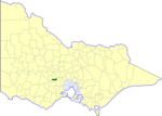
The Shire of Arapiles was a local government area in the Wimmera region of western Victoria, Australia. The shire covered an area of 2,342.62 square kilometres...
4 KB (267 words) - 11:31, 12 May 2023

from the amalgamation of the Shire of Kaniva and parts of the Shire of Kowree, Shire of Arapiles and Shire of Glenelg. The Shire is governed and administered...
9 KB (487 words) - 19:53, 10 February 2024

1995 by the amalgamation of the City of Horsham, most of the Shire of Wimmera and Shire of Arapiles, and part of the Shire of Kowree. The Rural City is...
10 KB (574 words) - 08:12, 31 January 2024

On 20 January 1995, the Shire of Wimmera was abolished, and along with the City of Horsham and parts of the Shires of Arapiles and Kowree, was merged into...
5 KB (353 words) - 11:38, 12 May 2023

On 20 January 1995, the Shire of Kowree was abolished, and along with the Shire of Kaniva and parts of the Shires of Arapiles and Glenelg, was merged...
4 KB (283 words) - 11:35, 12 May 2023

The Shire of Heytesbury was a local government area about 200 kilometres (124 mi) west-southwest of Melbourne, the state capital of Victoria, Australia...
4 KB (340 words) - 13:23, 17 December 2023

On 20 January 1995, the Shire of Kaniva was abolished, and along with the Shire of Kowree and parts of the Shires of Arapiles and Glenelg, was merged...
4 KB (273 words) - 11:34, 12 May 2023

Wimmera Southern Mallee (region) (category Regions of Victoria (state))
Australia border and north of the Great Dividing Range. Most of the Wimmera is very flat, with only the Grampians and Mount Arapiles rising above vast plains...
13 KB (1,327 words) - 10:32, 12 November 2023

The Shire of Waranga was a local government area about 165 kilometres (103 mi) north of Melbourne, the state capital of Victoria, Australia. The shire covered...
4 KB (300 words) - 11:38, 12 May 2023

The Shire of Strathfieldsaye was a local government area immediately to the east and southeast of the regional city of Bendigo, Victoria, Australia, and...
5 KB (303 words) - 11:37, 12 May 2023

Shire of Euroa was a local government area about 145 kilometres (90 mi) northeast of Melbourne, the state capital of Victoria, Australia. The shire covered...
4 KB (303 words) - 11:34, 12 May 2023

The Shire of Tallangatta was a local government area about 340 kilometres (211 mi) northeast of Melbourne, the state capital of Victoria, Australia. The...
4 KB (250 words) - 12:57, 13 September 2023

The Shire of Kerang was a local government area located in northwestern Victoria, Australia, along the Murray River. The shire covered an area of 3,254...
5 KB (371 words) - 11:35, 12 May 2023

The Shire of Leigh was a local government area about 140 kilometres (87 mi) west of Melbourne, the state capital of Victoria, Australia. The shire covered...
3 KB (206 words) - 21:18, 25 February 2024

The Shire of Winchelsea was a local government area about 110 kilometres (68 mi) southwest of Melbourne, the state capital of Victoria, Australia. The...
4 KB (258 words) - 11:38, 12 May 2023

Harrie Wade (category National Party of Australia members of the Parliament of Australia)
1934 and was elected to the Shire of Arapiles in 1941. At the 1949 election, he stood for the House of Representatives seat of Wimmera, but it was won by...
6 KB (358 words) - 23:59, 3 May 2024

The Shire of Pyalong was a local government area about 85 kilometres (53 mi) north of Melbourne, the state capital of Victoria, Australia. The shire covered...
3 KB (225 words) - 11:36, 12 May 2023

The Shire of Yarrawonga was a local government area on the Murray River, in the Goulburn Valley region, about 260 kilometres (162 mi) northeast of Melbourne...
5 KB (348 words) - 11:38, 12 May 2023

The Shire of Karkarooc was a local government area in northwestern Victoria, Australia. The shire covered an area of 3,719 square kilometres (1,435.9 sq mi)...
4 KB (330 words) - 11:34, 12 May 2023

The Shire of Alexandra was a local government area located about 130 kilometres (81 mi) northeast of Melbourne, the state capital of Victoria, Australia...
5 KB (351 words) - 04:50, 23 November 2023

The Shire of Barrabool was a local government area about 100 kilometres (62 mi) southwest of Melbourne, the state capital of Victoria, Australia. The shire...
4 KB (311 words) - 11:32, 12 May 2023
The Shire of Bungaree was a local government area northeast of the regional city of Ballarat, Victoria, Australia. The shire covered an area of 228 square...
3 KB (222 words) - 11:33, 12 May 2023

The Shire of Bass was a local government area about 120 kilometres (75 mi) south-southeast of Melbourne, the state capital of Victoria, Australia. The...
5 KB (407 words) - 11:32, 12 May 2023

The Shire of Tullaroop was a local government area about 170 kilometres (106 mi) northwest of Melbourne, the state capital of Victoria, Australia, surrounding...
4 KB (359 words) - 11:37, 12 May 2023

Shire of Mirboo was a local government area about 160 kilometres (99 mi) southeast of Melbourne, the state capital of Victoria, Australia. The shire covered...
4 KB (270 words) - 11:35, 12 May 2023

The Shire of Numurkah was a local government area on the Murray River in the Goulburn Valley region, about 210 kilometres (130 mi) north of Melbourne...
5 KB (387 words) - 11:36, 12 May 2023

The Shire of Rutherglen was a local government area about 275 kilometres (171 mi) north-northeast of Melbourne, the state capital of Victoria, Australia...
4 KB (275 words) - 11:37, 12 May 2023

The Shire of Walpeup was a local government area in northwestern Victoria, Australia, along the South Australian border. The shire covered an area of 10...
4 KB (239 words) - 11:38, 12 May 2023

36°42′00″S 142°12′00″E / 36.70000°S 142.20000°E / -36.70000; 142.20000 Arapiles • Blackheath (1886–1961 Youngvale) • Brimpaen (1886–1957) • Bungalally...
136 KB (12,146 words) - 05:09, 28 June 2024

The Shire of Alberton was a local government area about 220 kilometres (137 mi) southeast of Melbourne, the state capital of Victoria, Australia. The shire...
4 KB (264 words) - 11:31, 12 May 2023