
The Shire of Merredin is a local government area in the Wheatbelt region of Western Australia, about 250 kilometres (155 mi) east of Perth, the state capital...
8 KB (548 words) - 04:02, 6 June 2024

Merredin /ˈmɛrədɪn/ is a town in Western Australia, located in the central Wheatbelt roughly midway between Perth and Kalgoorlie, on Route 94, Great Eastern...
16 KB (1,782 words) - 04:31, 1 May 2024

Wheatbelt (Western Australia) (redirect from Wheatbelt region of Western Australia)
Shire of Merredin – WDC office in Merredin Shire of Mount Marshall Shire of Mukinbudin Shire of Narembeen Shire of Nungarin Shire of Trayning Shire of...
18 KB (1,526 words) - 04:20, 1 May 2024
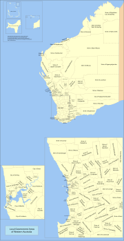
plus the Shire of Peppermint Grove Town – predominantly inner urban, plus the Town of Port Hedland The Shire of Christmas Island and the Shire of Cocos (Keeling)...
59 KB (1,456 words) - 23:12, 21 June 2024
registered places within the Shire of Merredin: "Shire of Merredin Heritage Places". inherit.stateheritage.wa.gov.au. Heritage Council of Western Australia. Retrieved...
7 KB (123 words) - 08:35, 30 January 2024

The MerredinLink is a rural passenger train service in Western Australia operated by Transwa between East Perth and Merredin. The MerredinLink was introduced...
7 KB (364 words) - 06:52, 2 July 2023

Burracoppin, Western Australia (category Shire of Merredin)
Burracoppin is a townsite on the Great Eastern Highway, east of Merredin in the Wheatbelt region of Western Australia. The town was gazetted in 1891. It takes...
5 KB (410 words) - 03:13, 30 March 2024

Merredin railway station is located on the Eastern Goldfields Railway in Western Australia. It is in the town of Merredin. The original Merredin station...
8 KB (567 words) - 21:47, 23 June 2024
Booraan, Western Australia (category Shire of Merredin)
Geographically, Booraan is an unbounded locality within the Shire of Merredin, located between the towns of Merredin and Burracoppin. It has been an identified rail...
2 KB (174 words) - 08:02, 1 November 2022

The Shire of Mukinbudin is a local government area in the Wheatbelt region of Western Australia, about 80 kilometres (50 mi) north of Merredin and about...
8 KB (580 words) - 08:04, 25 February 2023

The Shire of Bruce Rock is a local government area in the Wheatbelt region of Western Australia, about 50 kilometres (31 mi) south of Merredin and about...
7 KB (431 words) - 06:54, 25 February 2023

Solar power in Australia (redirect from The History of Solar Power in Australia)
Action. Retrieved 19 April 2016. "Solar Farm". Merredin Solar Farm. Retrieved 3 August 2020. "Panels". Merredin Solar Farm. Retrieved 3 August 2020. "August...
62 KB (5,249 words) - 08:18, 1 July 2024
Muntadgin, Western Australia (category Shire of Merredin)
West Australian. Perth: National Library of Australia. 6 May 1931. p. 5. Retrieved 19 June 2011. "Shire of Merredin Townships". 2010. Archived from the original...
3 KB (284 words) - 01:18, 10 February 2023

shires of Merredin to the north, and Kondinin to the south. The Shire has a land area of 3,833 square kilometres (1,480 sq mi) and its seat of government...
6 KB (421 words) - 08:05, 25 February 2023

Hines Hill, Western Australia (category Shire of Merredin)
Hines Hill is a town located 240 km (150 mi) east of Perth, between the towns of Merredin and Doodlakine in Western Australia. The town is situated on...
4 KB (298 words) - 01:18, 10 February 2023

Trayning, Western Australia (redirect from Trayning to Merredin railway line)
Nungarin–Wyalkatchem Road. At the 2006 census, Trayning had a population of 122. When the Dowerin to Merredin railway was planned in 1910, Trayning was selected as the...
8 KB (549 words) - 06:25, 12 February 2023
the Wheatbelt region of Western Australia, located in the Shire of Mukinbudin approximately 57 kilometres (35 mi) north of Merredin and approximately 260...
4 KB (405 words) - 08:40, 6 May 2024

north-northwest of Merredin and about 300 kilometres (186 mi) northeast of the state capital, Perth. The Shire covers an area of 10,190 square kilometres...
9 KB (717 words) - 08:03, 25 February 2023

1911, responsibility for the area was transferred to the Merredin Road Board. The Shire of Nungarin originated as the Nungarin Road District, which was...
8 KB (593 words) - 06:25, 11 October 2023
(Kulin) Lake Grace Shire Council Libraries (Shire of Lake Grace) Merredin Regional Library (Merredin) Narembeen Library (Shire of Narembeen) Northam Region...
13 KB (1,193 words) - 07:15, 23 May 2024

Merredin, Mount Marshall, Mukinbudin, Narembeen, Nungarin, Quairading, Tammin, Trayning, Westonia, Wyalkatchem and Yilgarn and the Mid West Shire of Wiluna...
11 KB (655 words) - 18:01, 28 April 2024

town of Tammin, about 80 kilometres (50 mi) west of Merredin and about 180 kilometres (112 mi) east of Perth, the state capital. Originally the area was...
8 KB (474 words) - 12:51, 3 July 2023

Nangeenan, Western Australia (category Shire of Merredin)
Nangeenan is a small townsite west of Merredin on Great Eastern Highway, in the Wheatbelt region of Western Australia (WA). It has a local hall which has...
2 KB (170 words) - 19:10, 1 April 2023

The Shire of Kellerberrin is a local government area in the Wheatbelt region of Western Australia, about 60 kilometres (37 mi) west of Merredin and about...
7 KB (509 words) - 12:34, 16 February 2023

The Shire of Trayning is a local government area in the Wheatbelt region of Western Australia, about 60 kilometres (37 mi) northwest of Merredin and about...
8 KB (581 words) - 02:17, 11 May 2024

The Shire of Cunderdin is a local government area in the Wheatbelt region of Western Australia, about 105 kilometres (65 mi) west of Merredin and about...
8 KB (580 words) - 09:41, 16 April 2023

Kununoppin (category Shire of Trayning)
had a population of 151. The site of a railway siding on the Dowerin to Merredin railway, Kununoppin was gazetted as a townsite in 1911. The town's name...
4 KB (313 words) - 19:42, 25 April 2024

The Shire of East Pilbara is one of the four local government areas in the Pilbara region of Western Australia. With an area of 372,571 square kilometres...
7 KB (529 words) - 18:49, 10 February 2024

The Shire of Cocos (Keeling) Islands is a local government area which manages local affairs on the Australian external territory of Cocos (Keeling) Islands...
7 KB (613 words) - 14:41, 3 March 2024

Bruce Rock, Western Australia (category Shire of Bruce Rock)
Wheatbelt region of Western Australia, approximately 243 kilometres (151 mi) east of Perth and 48 kilometres (30 mi) southwest of Merredin. It is the main...
4 KB (368 words) - 13:42, 30 December 2023