
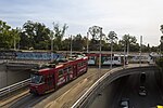
St Kilda Road is a street in Melbourne, Victoria, Australia. It is part of the locality of Melbourne which has the postcode of 3004, and along with Swanston...
19 KB (2,237 words) - 16:25, 16 August 2024

St Kilda is an inner seaside suburb in Melbourne, Victoria, Australia, 6 km (4 miles) south-east of the Melbourne central business district, located within...
74 KB (8,975 words) - 20:53, 21 May 2024

St Kilda East is a suburb in Melbourne, Victoria, Australia, 6 km south-east of Melbourne's Central Business District, located within the Cities of Glen...
26 KB (2,545 words) - 00:46, 10 September 2024
point of the major roads Punt Road, St Kilda Road, Dandenong Road/Queens Way/Princes Highway and Fitzroy Street. Up until 1966, St Kilda Junction, along...
8 KB (914 words) - 12:24, 3 May 2024

bushrangers, took place on St Kilda Road, then a track through the scrub from the city to the seaside settlement of St Kilda. However only two events are...
6 KB (866 words) - 00:48, 20 August 2024

350 St Kilda Road, currently known as St. James Apartments, is a 120 m high apartment building on St Kilda Road in Melbourne, Australia. It consists of...
1 KB (134 words) - 13:27, 19 September 2022
Wesley College, Melbourne (section St Kilda Road)
college consists of three main metropolitan campuses in Melbourne, St Kilda Road, Glen Waverley and Elsternwick, residential/boarding facilities (Glen...
47 KB (4,783 words) - 04:14, 13 August 2024
The St Kilda Football Club, nicknamed the Saints, is a professional Australian rules football club based in Melbourne, Victoria. The club plays in the...
161 KB (9,795 words) - 00:56, 15 September 2024

lines along St Kilda Road and Chapel Street to light rail standards. In 2006, the state government considered a plan to construct a combined road and rail...
158 KB (13,392 words) - 06:32, 15 September 2024

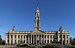
Phillip. The council met at the St Kilda Town Hall, at the intersection of St Kilda Road and Carlisle Street, St Kilda. The facility is now the main council...
6 KB (473 words) - 03:32, 5 September 2023

interchange on the Melbourne tram network. It is located on St Kilda Road south of Domain Road, adjacent to Kings Domain. It is one of the busiest interchanges...
6 KB (195 words) - 18:13, 16 September 2024

City of Port Phillip (redirect from St Kilda City Council)
Street (Middle Park), Fitzroy Street (St Kilda), Acland Street (St Kilda), Carlisle Street (Balaclava) and Ormond Road (Elwood). A number of significant employment...
16 KB (1,334 words) - 23:50, 16 August 2024
on St Kilda Road, then south along Albert Road, north up Canterbury Road, along the rear of the north side of St Vincent Place, zigzags west along St Vincent...
14 KB (1,589 words) - 04:39, 27 August 2024

houses its collection across two sites: NGV International, located on St Kilda Road in the Melbourne Arts Precinct of Southbank, and the Ian Potter Centre:...
75 KB (5,917 words) - 07:32, 16 September 2024
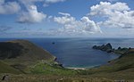
St Kilda (Scottish Gaelic: Hiort) is a remote archipelago situated 35 nautical miles (65 km; 40 mi) west-northwest of North Uist in the North Atlantic...
111 KB (13,436 words) - 14:06, 6 September 2024
along St Kilda Road and will provide access to the nearby Royal Botanic Gardens and Albert Park. Anzac station is being built below St Kilda Road in Melbourne...
13 KB (609 words) - 04:23, 9 September 2024

Southbank is bordered to the north by the Yarra River, and to the east by St Kilda Road. Southbank's southern and western borders are bounded by Dorcas Street...
19 KB (2,200 words) - 09:45, 5 June 2024
St Kilda Beach is a beach located in St Kilda, Port Phillip, Victoria, Australia, 6 kilometres (3.7 mi) south from the Melbourne city centre. It is Melbourne's...
11 KB (1,442 words) - 14:29, 17 May 2024

memorial in Melbourne, Victoria, Australia, located in Kings Domain on St Kilda Road. It was built to honour the men and women of Victoria who served in...
61 KB (6,160 words) - 07:14, 19 August 2024

Swanston Street (category Infobox Australian road articles with an infobox mapframe map)
to the west. To the south it becomes St Kilda Road after the intersection with Flinders Street, whilst the road's northern end is in the suburb of Carlton...
14 KB (1,406 words) - 08:43, 27 April 2024

government area. St Kilda West recorded a population of 2,951 at the 2021 census. St Kilda West is bounded by Albert Park and Canterbury Road in the north-east...
10 KB (1,078 words) - 00:38, 31 October 2023
embankment with a bridge over St Kilda Road. A possible reason for the construction of the loop line connecting through to St Kilda was the difficulty experienced...
10 KB (865 words) - 05:28, 23 May 2024

East over 14.9-kilometre (9.3 mi) of double track via Swanston Street, St Kilda Road and Caulfield. It is serviced out of Glenhuntly depot utilising Z and...
12 KB (884 words) - 05:40, 11 September 2024

section of Sydney Road would run via Swanston Street to the southern suburbs. Route 16 ran the service between Coburg and St Kilda Beach. After 1936,...
8 KB (639 words) - 01:45, 26 April 2024

Flinders Street and the Yarra River. It includes the grand boulevardes of St Kilda Road, Royal Parade and Victoria Street marking the entrance to Victoria Parade...
42 KB (4,227 words) - 02:08, 11 September 2024
Nepean Highway (redirect from Point Nepean Road)
as St Kilda Road and heading south through the Melbourne Arts Precinct, today Nepean Highway is declared to commence at St Kilda Junction as St Kilda Road...
26 KB (1,607 words) - 07:41, 13 August 2024

(large park bordered by offices on St Kilda Road, private residences off Punt Road, Commercial Road and Toorak Road, featuring recreational facilities...
20 KB (2,484 words) - 05:15, 5 July 2024

from St Kilda Beach via South Melbourne to St Kilda Road at City Road. Route 1 traverses the section of this line between Clarendon Street and St Kilda Road...
9 KB (905 words) - 15:24, 30 June 2024

extended west to Punt Road on 14 March 1911 and again, to St Kilda Road on 14 September 1912, connecting with the St Kilda Road cable tram to the city...
8 KB (614 words) - 02:54, 1 June 2024

St Kilda station is a current tram stop and former railway station, located in the Melbourne suburb of St Kilda, Australia, and was the terminus of the...
12 KB (1,142 words) - 14:05, 18 September 2024