
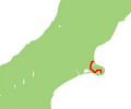
State Highway 47 (SH 47) is a New Zealand state highway in the central North Island. It provides a link from SH 4 at National Park to SH 41 at Tokaanu...
4 KB (298 words) - 20:00, 25 August 2024
The New Zealand state highway network is the major national highway network in New Zealand. Nearly 100 roads in the North and South Islands are state highways...
23 KB (2,353 words) - 19:58, 25 August 2024
State Highway 67 (SH 67) is a New Zealand state highway located in the northern parts of the South Island of New Zealand. It is 51.2 km long usually on...
4 KB (396 words) - 20:01, 25 August 2024

State Highway 4 is the shortest of New Zealand's eight national highways. It runs north-south across rugged hill country, forming a short cut between two...
4 KB (294 words) - 19:58, 25 August 2024
This is a list of highways of the New Zealand state highway network and some touring routes. State highways are administered by NZ Transport Agency Waka...
34 KB (323 words) - 19:58, 25 August 2024

State Highway 3 (SH 3) is one of New Zealand's eight national state highways. It serves the west coast of the country's North Island and forms a link between...
21 KB (1,778 words) - 19:58, 25 August 2024
State Highway 46 (SH 46) is a New Zealand state highway in the central North Island. For its entire length SH 46 shares the name Lake Rotoaira Road. It...
2 KB (175 words) - 20:00, 25 August 2024

State Highway 10 (SH 10) is a road in the Far North District of the North Island of New Zealand. Both ends of the road adjoin SH 1. With the exception...
4 KB (266 words) - 19:59, 25 August 2024

State Highway 48 (SH 48), also known as Bruce Road, is one of New Zealand's shortest state highways. It provides access to Whakapapa Skifield on the slopes...
2 KB (196 words) - 20:00, 25 August 2024
State Highway 41 (SH 41) is a New Zealand state highway in the central North Island that runs from Manunui, just south of Taumarunui on SH 4 to Tūrangi...
2 KB (179 words) - 20:00, 25 August 2024
State Highway 54 (SH 54) is a New Zealand state highway that runs across nearly all of the Manawatū District in the North Island. It runs from SH 1 at...
3 KB (359 words) - 20:00, 25 August 2024
State Highway 49 (SH 49) is a New Zealand state highway, linking SH 4 and SH 1, via the tourist town of Ohakune. It forms the southern part of the ring...
5 KB (379 words) - 20:00, 25 August 2024

New Zealand (Māori: Aotearoa [aɔˈtɛaɾɔa]) is an island country in the southwestern Pacific Ocean. It consists of two main landmasses—the North Island...
267 KB (22,358 words) - 10:50, 26 August 2024
47 New Zealand State Highway 47 unbuilt expressway S47 National road 47 A47 (Birmingham - Great Yarmouth) Alabama State Route 47 Arkansas Highway 47 (former)...
6 KB (454 words) - 18:32, 27 May 2024
State Highway 23 (SH 23) is a New Zealand state highway that connects the towns of Raglan and Hamilton. SH 23 commences in the Hamilton suburb of Frankton...
18 KB (1,112 words) - 19:59, 25 August 2024
State Highway 75 (SH 75) is a state highway in New Zealand servicing the Banks Peninsula region, connecting Christchurch on the northwestern part of the...
4 KB (440 words) - 20:01, 25 August 2024

seat of the Horowhenua District, in the Manawatū-Whanganui region of New Zealand's North Island. It is located east of Lake Horowhenua, around 95 km north...
22 KB (1,585 words) - 16:41, 18 August 2024
during 2024 in New Zealand. Regal and vice-regal Government Other party leaders in parliament Judiciary Main centre leaders Head of state – Charles III...
213 KB (16,238 words) - 13:10, 29 August 2024

that began in the 1980s. New Zealand's transport infrastructure is "generally well developed." The New Zealand state highway network consists of 11,000 km...
136 KB (12,549 words) - 04:23, 25 August 2024
welcomed the new community members. State Highway 6 passes through the town between Queenstown and Invercargill. State Highway 96, a regional highway, connects...
16 KB (1,281 words) - 21:42, 22 July 2024

of New Zealand. It is about 140 km south of Christchurch, and inland from Timaru, which is 38 km to the south. Geraldine is located on State Highway 79...
40 KB (3,465 words) - 13:24, 23 August 2024

the South Island of New Zealand. It is on the banks of the Clutha River (at the confluence of the Manuherikia River), on State Highway 8, 188 kilometres...
54 KB (5,268 words) - 11:47, 18 August 2024
when early settlers observed fog on the hills known as the Nobbles. State Highway 96 passes through Nightcaps as it runs between Ohai and Winton. The...
15 KB (1,569 words) - 21:41, 22 July 2024

State Highway 43 marker State Highway 44 marker State Highway 45 marker State Highway 46 marker State Highway 47 marker State Highway 48 marker State Highway...
66 KB (4,844 words) - 20:04, 28 August 2024

Coast of New Zealand's South Island. The township is beside the Haast River, 3 kilometres (2 mi) south of Haast Junction, on State Highway 6. The Haast...
21 KB (2,192 words) - 22:01, 14 July 2024

town in the Rangitikei District of New Zealand. It is in a fertile farming area at the junction of State Highways 1 and 3, 28 km (17 mi) northwest of...
17 KB (1,500 words) - 11:45, 14 July 2024

Wellington, New Zealand. It is seven kilometres north of the city centre, at the top of the Ngauranga Gorge, on the main route to Porirua (State Highway 1). It...
22 KB (2,058 words) - 01:06, 30 July 2024

Murchison is a town in the Tasman Region of the South Island of New Zealand. It is near the western end of the "Four Rivers Plain", at the confluence...
20 KB (1,791 words) - 23:57, 11 August 2024

The climate of New Zealand is varied due to the country's diverse landscape. Most regions of New Zealand belong to the temperate zone with a maritime...
37 KB (3,534 words) - 13:35, 30 July 2024
road (Namibia) Mahendra Highway Rijksweg 1 New Zealand State Highway 1 New Zealand State Highway 1B New Zealand State Highway 1C NIC-1 Route nationale...
20 KB (1,282 words) - 08:59, 27 August 2024