
1967, Steeles Avenue was named Upper Base Line (Lower Base Line being Eglinton Avenue, which is still named as such) in Halton County. Steeles became...
25 KB (1,863 words) - 13:31, 29 August 2024
List of north–south roads in Toronto (redirect from Broadview Avenue)
junction with Highway 401. Highway 404 was opened from Sheppard Avenue East to Steeles Avenue East in 1979 and extended north of the Metro Toronto limits...
110 KB (10,711 words) - 00:18, 19 October 2024
List of east–west roads in Toronto (redirect from Wilson Avenue)
John C. Steele, is known for inventing the Steeles Improved Road Machine, an early grader. Steeles Avenue serves as the boundary line between Toronto...
74 KB (7,692 words) - 00:30, 19 October 2024

over. The Brampton Transit 11 Steeles operates westward only to Steeles, and the 511 Züm Steeles operates express from Steeles. Finch West station (on the...
14 KB (1,409 words) - 00:37, 22 August 2024

Dufferin Street (section North of Steeles Avenue)
Exhibition Place, continues north to Toronto's northern boundary at Steeles Avenue with some discontinuities and continues into Vaughan, where it is designated...
17 KB (1,756 words) - 05:05, 22 October 2024

Toronto, from Keele station to Steeles Avenue. York Region Transit route 165 Weston serves Weston Road north of Steeles Avenue, running from Pioneer Village...
10 KB (997 words) - 14:19, 24 June 2024
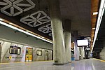
Pioneer Village station (redirect from Steeles West)
subway. It is located under the intersection of Northwest Gate and Steeles Avenue, at the city boundaries of Toronto and Vaughan, Ontario, Canada. A Toronto...
27 KB (1,978 words) - 19:40, 11 October 2024
realigned at Steeles Avenue to connect the broken section, and was realigned east 300 m between Highway 407 and 16th Avenue. From Steeles Avenue, it is a...
8 KB (579 words) - 04:24, 21 September 2024

Avenue Kennedy Road Finch Avenue Steeles Avenue Denison Street 14th Avenue Highway 407 Highway 7 16th Avenue Bur Oak Avenue Major Mackenzie Drive East Elgin...
13 KB (869 words) - 12:09, 28 September 2024
Avenue East. Toronto Transit Commission's bus routes 53 Steeles East operates along Steeles Avenue East and 43 Kennedy terminates by looping there, as does...
9 KB (848 words) - 20:45, 29 August 2024

from Passmore Avenue to McNicoll Avenue and then to Steeles) in the future to connect to Donald Cousens Parkway via a widened Steeles Avenue. As of December...
8 KB (775 words) - 17:55, 25 July 2024

at 3600 Steeles Avenue East and was completed in 1995. IBM Canada's previous head office was located across the street at 3500 Steeles Avenue East (now...
3 KB (344 words) - 20:14, 25 August 2024

operations on Brimley Road between Steeles Avenue and 14th Avenue as Route 6 Brimley while TTC operated south of Steeles Ave to Scarborough Centre (128 Brimley...
11 KB (1,142 words) - 02:32, 26 July 2024
south of Steeles, incorporating the existing segment of the Metro-built DVP between Sheppard and Highway 401. The first section south of Steeles opened...
47 KB (4,682 words) - 18:58, 28 September 2024

shoreline. It continues north through Toronto to the Toronto boundary at Steeles Avenue. It is a four-lane thoroughfare throughout Toronto. The roadway continues...
19 KB (1,865 words) - 21:05, 2 October 2024

Ontario, Canada. It is located at 1713 Steeles Avenue East, near the community of Bramalea at Steeles Avenue East and Bramalea Road. In addition to the...
8 KB (708 words) - 00:59, 3 February 2024
List of roads in Brampton (section Steeles Avenue)
south of Steeles, but resetting to "1" north of it to Queen Street, where the numbers return to the standard sequence in the 9000s. Steeles Avenue is the...
57 KB (5,453 words) - 15:27, 4 August 2024

Street Dundas Street St. Clair Avenue Eglinton Avenue Lawrence Avenue Wilson Avenue Sheppard Avenue Finch Avenue Steeles Avenue A portion of Keele was once...
10 KB (744 words) - 12:08, 17 September 2024

along the street from the station to Steeles. Landmarks and notable sites along Steeles from west to east "Steeles Ave. route". Google Maps. Retrieved...
8 KB (519 words) - 14:34, 20 September 2024
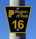
List of numbered roads in York Region (redirect from 16th Avenue (York Region))
roads originating in Toronto retains the proper names from south of Steeles Avenue. Roads on Georgina Island are maintained by Chippewas of Georgina Island...
45 KB (1,081 words) - 23:24, 23 October 2024
Express within Toronto and York Region Transit's 20 Jane buses north of Steeles Avenue. It was originally part of the Transit City proposal announced in March...
8 KB (755 words) - 02:04, 23 September 2024

Woodbridge, Ontario (redirect from Woodbridge Avenue)
southwest quadrant, west of Highway 400, east of Highway 50, north of Steeles Avenue, and generally south of Major Mackenzie Drive. It was once an independent...
22 KB (2,222 words) - 13:21, 27 July 2024

Street in Markham, where its name changes to Leslie Street. North of Steeles Avenue, the road is officially named as York Regional Road 12. From south to...
7 KB (451 words) - 17:10, 5 October 2024

Steeles is a suburban neighbourhood in Toronto, Ontario, Canada. Steeles is located in the north-eastern part of Toronto in the former suburb of Scarborough...
14 KB (1,202 words) - 16:28, 16 January 2024

Sheppard Avenue to the 2000 block under the Canadian National Railway tracks in a short distance. It exits Toronto and enters York Region at Steeles Avenue, west...
8 KB (620 words) - 02:22, 26 September 2024

The Shops on Steeles and 404 is a small 70-store community mall at the corner of Steeles Avenue East and Don Mills Road in Markham, Ontario. Aside from...
5 KB (439 words) - 15:15, 18 October 2024

stations. YRT northbound buses are allowed to pick up passengers south of Steeles Avenue if they are heading into York Region (but passengers must flag the bus...
31 KB (3,640 words) - 03:19, 10 October 2024

Avenue), North York Dufferin and Steeles Power Centre (unofficial name) (Dufferin Street and Steeles Avenue), North York Golden Mile (Eglinton Avenue...
22 KB (2,251 words) - 00:13, 21 October 2024

current Steeles Avenue / Ninth Line intersection, widening the two-laned Steeles to six west of that point, and extending Morningside north to Steeles immediately...
26 KB (2,499 words) - 21:42, 24 August 2024

northernmost neighbourhoods, located along the northern boundary of Steeles Avenue in the former city of North York. The neighbourhood is so named because...
10 KB (904 words) - 21:44, 8 October 2024