
North Fork Stillaguamish (45 miles (72 km)) and the South Fork Stillaguamish. The two forks join near Arlington. From there the Stillaguamish River proper...
10 KB (848 words) - 20:08, 29 July 2024

The Stillaguamish people (still-uh-GWAH-mish; Lushootseed: stuləgʷabš) are a Southern Coast Salish people Indigenous to the Stillaguamish River valley...
27 KB (2,986 words) - 21:02, 19 January 2024
tribe Stillaguamish River Stillaguamish Reservation, Washington This disambiguation page lists articles associated with the title Stillaguamish. If an...
475 bytes (58 words) - 22:21, 26 September 2013
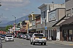
States, part of the Seattle metropolitan area. The city lies on the Stillaguamish River in the western foothills of the Cascade Range, adjacent to the city...
130 KB (11,450 words) - 21:32, 15 August 2024

from the aboriginal Stillaguamish, listed on the Treaty of Point Elliot as the Stoluck-wa-mish River Tribe. Although the Stillaguamish had existed for thousands...
8 KB (695 words) - 21:39, 26 February 2024
Boulder River (Washington), a tributary of the North Fork Stillaguamish River in Washington (U.S. state) in the United States The Boulder River, New Zealand...
686 bytes (132 words) - 09:38, 15 December 2014

sending mud and debris to the south across the North Fork of the Stillaguamish River, engulfing a rural neighborhood, and covering an area of approximately...
61 KB (5,122 words) - 14:10, 3 August 2024

the Stillaguamish River near Camano Island. As of the 2020 census, its population is 7,705. The Stanwood area has been home to the Stillaguamish people...
76 KB (7,390 words) - 23:00, 19 August 2024

Darrington the Sauk River comes so close to the head of the North Fork Stillaguamish River that boats used to portage across the divide. The name "Sauk" comes...
10 KB (932 words) - 03:35, 27 December 2022
Creek Sauk River Suiattle River Clear Creek White Chuck River Sloan Creek Cascade River Bacon Creek Goodell Creek Stillaguamish River Boulder River Snohomish...
15 KB (1,143 words) - 13:12, 22 August 2024
river system with the Stillaguamish River separated from the Sauk/Skagit Rivers. Lahar debris was deposited along both the Skagit and Stillaguamish Rivers...
29 KB (2,947 words) - 23:23, 27 July 2024

Washington, United States. It is located between the Pilchuck and Stillaguamish rivers in the western foothills of the Cascade Range, northeast of Lake...
56 KB (5,791 words) - 21:16, 17 June 2024
located to the west of Darrington, south of the North Fork of the Stillaguamish River and approximately 50 air miles (80 km) from Seattle. The population...
10 KB (883 words) - 00:25, 8 May 2024

increase fish and bird abundance and diversity. Research in the Stillaguamish River basin, approximately 50 miles (80 km) north of Lake Sammamish, found...
12 KB (1,209 words) - 16:11, 1 June 2024
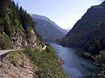
Falls to Barlow Pass follows the Stillaguamish River. The portion from Barlow Pass to Darrington follows the Sauk River. The "inside" of the highway's namesake...
11 KB (1,023 words) - 17:19, 29 May 2024
Sauk River and Suiattle River continued to drain into the future North Fork Stillaguamish River until eruptions of Glacier Peak choked the rivers with...
22 KB (2,203 words) - 06:19, 22 August 2024

roadway travels parallel to a fork of the Stillaguamish River from Arlington to Darrington, the Sauk River from Darrington to Rockport and the Whitehorse...
38 KB (3,565 words) - 04:32, 15 June 2024

"The Importance of Beaver Ponds to Coho Salmon Production in the Stillaguamish River Basin, Washington, USA" (PDF). Archived (PDF) from the original on...
108 KB (10,773 words) - 22:00, 21 July 2024

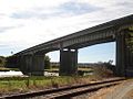
ushering in the arrival of permanent summer homes on the island. The Stillaguamish River bridge to Stanwood was replaced in July 1950 by the Mark Clark Bridge...
39 KB (3,951 words) - 21:21, 14 August 2024

State Highway 1Y (SSH 1Y). The state funded new bridges across the Stillaguamish River and Davis Slough and later renumbered the highway as SR 532 in 1964...
15 KB (1,510 words) - 04:32, 15 June 2024

Sauk and North Fork Stillaguamish rivers. Darrington is connected to nearby areas by State Route 530, which runs along the two rivers towards the city of...
98 KB (9,725 words) - 20:50, 16 August 2024

Canada, and to the west by a line running north from the mouth of the Sekiu River on the Olympic Peninsula. Under this definition, significant parts of the...
53 KB (4,957 words) - 08:16, 7 August 2024

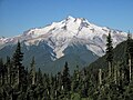
Forest. It rises 4,000 feet (1,200 m) above the Stillaguamish River and the Mountain Loop Highway. Stillaguamish Peak is located in the marine west coast climate...
5 KB (515 words) - 07:38, 8 April 2024
U.S. state of Washington. It's located on Florence Island in the Stillaguamish River delta. A post office called Florence was established in 1884, and...
6 KB (532 words) - 05:12, 25 July 2023

Pineapple Express is a specific recurring atmospheric river both in the waters immediately northeast of the Hawaiian Islands and extending northeast to...
24 KB (2,475 words) - 23:03, 15 August 2024

of Boulder River Wilderness to join the Stillaguamish River. The Stillaguamish empties into Port Susan, part of Puget Sound. The river's source is the...
3 KB (188 words) - 13:28, 18 May 2024

census. Silvana is located on an island in the Stillaguamish River floodplain. The main channel of the river passes to the north of the island, while South...
7 KB (527 words) - 21:34, 24 May 2024

Spokane River Squaxin Island Indian Reservation 936 1,979 The entirely of Squaxin Island and the town of Kamilche in Mason County Stillaguamish Indian...
7 KB (148 words) - 12:20, 4 June 2024
Florence Island is the main island formed by the diked river delta of the Stillaguamish River as it flows into Port Susan on Puget Sound. The historic...
4 KB (417 words) - 21:37, 1 April 2024
Bridge is a girder bridge that carried a State Route 532 across the Stillaguamish River between Stanwood, ishington, and Camano Island. It is the only form...
6 KB (425 words) - 21:35, 30 July 2024