The Struve Geodetic Arc is a chain of survey triangulations stretching from Hammerfest in Norway to the Black Sea, through ten countries and over 2,820...
12 KB (1,365 words) - 20:02, 19 June 2024

initiating a triangulation survey later named Struve Geodetic Arc in his honor. He was born to the aristocratic Struve family at Altona, Duchy of Holstein (then...
13 KB (1,283 words) - 07:01, 3 August 2024

completed survey triangulation measurements of the angular arc (named Struve Geodetic Arc). The measurements extended through over 2,820 km, from Hammerfest...
13 KB (1,524 words) - 07:36, 2 August 2024
Tallinn Struve Geodetic Arc The United Nations Educational, Scientific and Cultural Organization (UNESCO) World Heritage Sites are places of importance...
10 KB (398 words) - 09:45, 2 June 2024
Riga Kuldīga Struve Geodetic Arc The United Nations Educational, Scientific and Cultural Organization (UNESCO) World Heritage Sites are places of importance...
11 KB (495 words) - 22:51, 15 July 2024
Struve Geodetic Arc The United Nations Educational, Scientific and Cultural Organization (UNESCO) World Heritage Sites are places of importance to cultural...
8 KB (418 words) - 15:19, 20 May 2024
Vilnius Curonian Spit Kernavė Kaunas Struve Geodetic Arc The United Nations Educational, Scientific and Cultural Organization (UNESCO) designates World...
16 KB (628 words) - 18:06, 22 August 2024

Viik, T (2006). "F. W. Bessel and geodesy". Struve Geodetic Arc, 2006 International Conference, The Struve Arc and Extensions in Space and Time, Haparanda...
106 KB (11,309 words) - 02:43, 29 August 2024

arc measurement Norwood's arc measurement Boscovich and Maire's arc measurement Maclear's arc measurement Hopfner's arc measurement Struve Geodetic Arc...
7 KB (740 words) - 00:30, 20 August 2024
Rjukan–Notodden Alta Røros Urnes Vegaøyan Geirangerfjord Nærøyfjord Struve Geodetic Arc The United Nations Educational, Scientific and Cultural Organization...
22 KB (819 words) - 02:14, 28 August 2024
Sammallahdenmäki Suomenlinna Kvarken Old Rauma Petäjävesi Old Church Verla Struve Geodetic Arc The United Nations Educational, Scientific and Cultural Organization...
17 KB (630 words) - 22:53, 15 July 2024
and the United Kingdom. More ambitious undertakings such as the Struve Geodetic Arc across Eastern Europe (1816-1855) and the Great Trigonometrical Survey...
31 KB (3,346 words) - 06:28, 11 August 2024

Southern Öland High Coast Great Copper Mountain Varberg Radio Station Struve Geodetic Arc The United Nations Educational, Scientific and Cultural Organization...
26 KB (904 words) - 02:14, 28 August 2024

Viik, T (2006). "F. W. Bessel and geodesy". Struve Geodetic Arc, 2006 International Conference, The Struve Arc and Extensions in Space and Time, Haparanda...
81 KB (15,090 words) - 16:42, 27 August 2024

Rudi Geodetic Point (Romanian: Punctul Geodezic Rudi) is a point of the Struve Geodetic Arc in Rudi, Moldova. There is also an obelisk. Rudi Geodetic Point...
2 KB (88 words) - 14:18, 29 October 2023
Landscapes of Dauria and Uvs Nuur Basin are shared with Mongolia, and the Struve Geodetic Arc is shared with nine European countries. UNESCO lists sites under...
74 KB (1,945 words) - 18:04, 22 August 2024

internationally for its connection to Friedrich Georg Wilhelm von Struve and the Struve Geodetic Arc, of which it is the first reference point. The Tartu Observatory...
6 KB (524 words) - 20:54, 27 August 2023
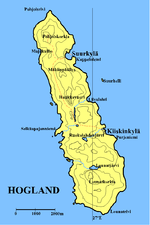
Since 1826, the hill Mäkiinpäällys has two of the points in the Struve Geodetic Arc. Gogland has a humid continental climate (Dfb) with oceanic influences...
10 KB (1,059 words) - 23:21, 15 April 2024

Paris meridian (redirect from French meridian arc)
Triangulation of Great Britain Meridian arc History of geodesy History of the metre Seconds pendulum Struve Geodetic Arc 48°50′11″N 2°20′14.025″E / 48.83639°N...
33 KB (3,940 words) - 16:14, 18 August 2024

Aavasaksa (category Struve Geodetic Arc)
Struve Geodetic Arc. As a result of this, UNESCO named Aavasaksa a World Heritage Site, along with the 33 other sites used in the Struve Geodetic Arc...
3 KB (258 words) - 10:43, 17 October 2023
other three are cultural. In addition to Białowieża Forest, the Struve Geodetic Arc is also a transnational site, and is shared with nine other countries...
19 KB (699 words) - 18:08, 22 August 2024
Struve Struve (crater), a crater on the Moon Struve functions, named after Karl Hermann Struve Struve Geodetic Arc, a World Heritage Site Otto Struve...
2 KB (315 words) - 18:21, 14 September 2021
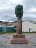
Norway. It is the location of the northernmost point of the Struve Geodetic Arc. It is a geodetic point, one of the 34 points selected for the World Heritage...
8 KB (466 words) - 03:25, 17 June 2024
Kyiv Residence of Metropolitans Lviv Odesa Chersonesus Struve Geodetic Arc The United Nations Educational, Scientific and Cultural Organization (UNESCO)...
36 KB (1,254 words) - 01:40, 23 August 2024

shared between Austria, Germany and Slovakia. The cultural site Struve Geodetic Arc is shared among Belarus, Estonia, Finland, Latvia, Lithuania, Norway...
38 KB (1,259 words) - 22:52, 2 August 2024
meridian (West Europe-Africa Meridian-arc) French Geodesic Mission to Lapland French Geodesic Mission Struve Geodetic Arc Rectifying latitude Geodesics on...
31 KB (4,707 words) - 22:38, 25 August 2024
Viik, T, F. W. Bessel and Geodesy, vol. Struve Geodetic Arc, 2006 International Conference, The Struve Arc Extension in Space and Time, Haparanda and...
5 KB (624 words) - 16:27, 27 June 2023

Ashmyany (category Struve Geodetic Arc)
Ashmyany or Oshmyany is a city in Grodno Region, Belarus. It is located 50 kilometres (31 mi) from Vilnius in Lithuania, and serves as the administrative...
25 KB (1,980 words) - 18:20, 30 August 2024
Hungary), Muskauer Park / Park Mużakowski (Germany and Poland), the Struve Geodetic Arc (ten countries in Northern and Eastern Europe), and Erzgebirge/Krušnohoří...
80 KB (2,226 words) - 12:11, 30 June 2024
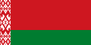
Castle, the Belovezhskaya Pushcha (shared with Poland), and the Struve Geodetic Arc (shared with nine other countries). Belarus portal Europe portal...
181 KB (16,491 words) - 13:15, 30 August 2024