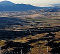
Susanville Municipal Airport (IATA: SVE, ICAO: KSVE, FAA LID: SVE) is a city-owned, public-use airport located five nautical miles (6 mi, 9 km) southeast...
3 KB (275 words) - 16:08, 15 January 2023

Lassen County, California (redirect from Susanville, CA μSA)
offense. Susanville Municipal Airport, Herlong Airport and Westwood Airport are general aviation airports in the county. The closest major airport is in...
49 KB (2,540 words) - 17:46, 21 August 2024

Susanville (formerly known as Rooptown) is a city in and is the county seat of Lassen County, California, United States. Susanville is located on the...
29 KB (2,421 words) - 16:43, 28 August 2024
a list of airports in California (a U.S. state), grouped by type and sorted by location. It contains all public-use and military airports in the state...
57 KB (648 words) - 06:25, 31 July 2024
high-performance automobile group within Chrysler Susanville Municipal Airport (IATA airport code), near Susanville, California This disambiguation page lists...
634 bytes (105 words) - 22:44, 15 May 2024
List of airports by IATA airport code: A - B - C - D - E - F - G - H - I - J - K - L - M - N - O - P - Q - R - S - T - U - V - W - X - Y - Z SA SB SC SD...
75 KB (275 words) - 08:41, 25 July 2024
Grant County Airport – Silver City, New Mexico KSVE – Susanville Municipal Airport – Susanville, California KSVH – Statesville Regional Airport – Statesville...
177 KB (15,592 words) - 22:09, 21 August 2024

before Susanville, US 395 makes a sharp turn avoiding the city, making a near complete loop around the Susanville Municipal Airport. North of Susanville, the...
56 KB (4,685 words) - 07:23, 30 August 2024
KSVE (category Airport disambiguation pages)
1994 and from June 1994 to September 2008 the ICAO code for Susanville Municipal Airport This disambiguation page lists articles associated with the title...
377 bytes (88 words) - 05:51, 4 August 2023

Edwards Air Force Base, Edwards, California. 64-1022 - Susanville Municipal Airport, Susanville, California.[citation needed] 64-1047 - National Museum...
57 KB (5,268 words) - 00:23, 29 August 2024

#6550 in Strum, Wisconsin.[citation needed] 67-15684 - Susanville Municipal Airport, Susanville, California.[citation needed] 67-15690 – Niagara Aerospace...
24 KB (2,362 words) - 19:42, 14 August 2024

Street as part of the All Veterans Memorial. 66-16374 - Susanville Municipal Airport, Susanville, California.[citation needed] 66-16879 – Jimmy Doolittle...
41 KB (3,727 words) - 11:08, 28 August 2024

Department Suisun City Police Department Sunnyvale Department of Public Safety Susanville Police Department Sutter Creek Police Department Taft Police Department...
55 KB (4,311 words) - 16:32, 19 August 2024
Machine Henson, C., Lassen-Modoc-Plumas Unit 2005 Fire Management Plan, (Susanville, California: State of California, Department of Forestry and Fire Protection...
23 KB (2,385 words) - 21:54, 24 June 2024

Mountain and Lancaster Modoc Sage Stage provides shuttles to Alturas and Susanville, California, along the northern US-395 corridor. Salt Lake Express provides...
102 KB (9,658 words) - 10:14, 23 August 2024

Northern California (section Airports)
Transportation in Yuba County There are 11 airports in Northern California categorized as Primary Service Commercial airports by the FAA: Bay Area Rapid Transit...
77 KB (5,759 words) - 14:01, 17 August 2024

and California State Route 299. U.S. 395 comes in from the south from Susanville and Reno. State Route 299 comes in from the west from Redding. Both highways...
25 KB (2,051 words) - 17:18, 13 August 2024
eBART Coliseum–Oakland International Airport line (people mover) Los Angeles Metro Rail (LACZ) San Francisco Municipal Railway (MUNI) Muni Metro Market Street...
52 KB (857 words) - 02:35, 13 August 2024

point about 1.75 miles (2.82 km) east-northeast of the Winnemucca Municipal Airport. From that point Grass Valley Road heads southerly through the Grass...
57 KB (4,533 words) - 05:31, 20 June 2024

available from the nearby Reno-Tahoe International Airport. There are also glider tours operated from the airport. The town is governed by a five-member Town...
40 KB (4,145 words) - 13:16, 26 August 2024

scheduled passenger airline service seasonally via the Eastern Sierra Regional Airport in Bishop with nonstop regional jet service operated to Los Angeles (LAX)...
32 KB (2,970 words) - 18:20, 24 August 2024

Auburn Municipal Airport is located three miles (5 km) north of town, and it is solely a general aviation airport. Auburn owns and operates this airport and...
31 KB (2,408 words) - 20:59, 22 August 2024

Janesville. Continued southwest winds threatened to push the fire towards Susanville. In Lassen National Park, the area burned within the park had doubled...
133 KB (9,154 words) - 14:24, 20 August 2024

14.9 24.0 15 I-580 south / US 395 – Carson City, Susanville Serves Reno–Tahoe International Airport and Reno-Sparks Convention Center; I-580 exit 36 and...
32 KB (1,625 words) - 00:59, 5 August 2024
Thruway bus provides connections to Oxnard and Santa Barbara. Tehachapi Municipal Airport is located approximately one mile east of the Park and Ride facility...
42 KB (4,088 words) - 19:38, 28 August 2024

Road. From there, it continues north, passing by the Bakersfield Municipal Airport and the Kern County Fairgrounds. Union Avenue widens to six lanes...
76 KB (3,793 words) - 18:00, 25 August 2024
and the Modesto Airport is located adjacent to the river shortly upstream. Dry Creek joins the Tuolumne from the north between the airport and the railroad...
70 KB (7,724 words) - 13:20, 15 August 2024
Lakeview Commons. South Lake Tahoe Mayor Wendy David spoke to the marchers. Susanville 112+ Residents from Lassen and Plumas counties marched along Main St from...
341 KB (16,119 words) - 20:33, 11 July 2024