
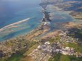
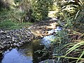
The Tākaka River lies in the northwest of New Zealand's South Island. It runs north for 70 kilometres, entering Golden Bay near the town of Tākaka. It...
3 KB (133 words) - 00:39, 14 April 2024

lower reaches of the Tākaka River. State Highway 60 runs through Takaka and follows the river valley before climbing over Tākaka Hill, to Motueka (57 km...
28 KB (2,655 words) - 02:02, 24 August 2024

Takaka Terrane. There is only one road winding over and around the flanks of Tākaka Hill, State Highway 60, following the valleys of the Tākaka River...
6 KB (729 words) - 06:22, 4 October 2024
nearby Tākaka River form part of the pass over which the only road between Tasman Bay and Golden Bay runs. For part of its journey, the river flows underground...
4 KB (224 words) - 00:41, 14 April 2024
boundary of Golden Bay Tākaka River, the main river through the New Zealand town Takaka Terrane, a geological feature Elsewhere Takaka, Afghanistan This disambiguation...
359 bytes (83 words) - 03:44, 25 July 2020

to reach the Tākaka River close to the town of Tākaka. On its way it passes close to the Te Waikoropupū Springs, which drain into the river and add significantly...
2 KB (91 words) - 00:39, 14 April 2024
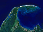
golden sand that is the country's longest sandspit. The Aorere and Tākaka rivers are the major waterways to flow into the bay from the south and the...
34 KB (3,460 words) - 09:35, 4 October 2024
Tākaka River eight kilometres south of Tākaka, just downstream where State Highway 60 crosses the Tākaka River. There are three rivers on the Takaka Plains...
7 KB (477 words) - 00:41, 14 April 2024
Waingaro River is a river of the Tasman Region of New Zealand. It is a tributary of the Waingaro River, which it meets 10 kilometres south of Tākaka. List...
2 KB (56 words) - 00:39, 14 April 2024

The Anatoki River is a river of New Zealand. It is located in the Tasman Region, and is a tributary of the Tākaka River and is one of the country's steepest...
3 KB (200 words) - 00:39, 14 April 2024

significant to Māori people. The springs feed Te Waikoropupū River, a short tributary of the Tākaka River. The horizontal visibility of the constantly 11.7 °C...
5 KB (592 words) - 01:20, 9 June 2024
0 mi) south of Tākaka. Located in the Tākaka valley, East Tākaka sits on the eastern side of the Tākaka River. The area developed from the 1860s, with...
5 KB (353 words) - 23:59, 23 September 2023
Devil River is a river of the Tasman Region of New Zealand's South Island. It flows southeast to reach the Devil River 15 kilometres southwest of Tākaka. List...
2 KB (55 words) - 00:39, 14 April 2024

to Tākaka township via Commercial Street. From there, alongside the Tākaka River at Paynes Ford (on a raised embankment between the Tākaka River and...
5 KB (532 words) - 07:37, 25 July 2024

Island. The river's waters are captured behind a dam to become the Cobb Reservoir; the outflow continues to join with the Tākaka River. The river is named...
3 KB (184 words) - 00:39, 14 April 2024
The Devil River is a river of New Zealand's Tasman Region. It starts between the Devil Range and the Anatoki Range and flows generally east through the...
2 KB (69 words) - 00:39, 14 April 2024

The Motupipi River is a short river of the Tasman Region of the South Island of New Zealand. Located in the Tākaka valley in Golden Bay, it used to be...
7 KB (695 words) - 02:32, 13 April 2024
Taipo River (Westland District) Taipoiti River Tairua River Takahue River Tākaka River Takaputahi River Takiritawai River Takou River Talbot River Tāmaki...
31 KB (2,843 words) - 05:08, 4 May 2024

Hole is being filled in. It is one of several important cave systems in Tākaka Hill, between Golden Bay and Tasman Bay. Starting at the surface as a 50-metre...
5 KB (607 words) - 16:03, 24 March 2024

Bay 10 kilometres northwest of Tākaka at Puramāhoi. List of rivers of New Zealand "Place name detail: Pariwhakaoho River". New Zealand Gazetteer. New Zealand...
2 KB (60 words) - 00:41, 14 April 2024
Sams Creek (West Virginia) Sams Creek (New Zealand), tributary to the Tākaka River that is subject to ongoing mining proposals This disambiguation page...
256 bytes (65 words) - 05:00, 29 April 2024

Station can be reached from Upper Tākaka via a sealed but winding and narrow 16 km (9.9 mi) road along Tākaka River. The power station building is situated...
12 KB (1,370 words) - 03:25, 24 May 2024
Māori tradition, the river is inhabited by a taniwha called Kaiwhakaruaki, who used to attack the people of Motueka and Tākaka. This tradition derives...
3 KB (156 words) - 00:39, 14 April 2024
Motueka (redirect from Takaka Hills)
areas. Extensive limestone cave systems (including Harwoods Hole in the Tākaka Hill area north of Motueka) attract cavers and rock climbers. Sea kayaking...
45 KB (3,786 words) - 06:15, 4 October 2024

stones and debris in a trickle of water beside Cobb Dam Road in the upper Tākaka River valley, within Kahurangi National Park. The sample of 20 collected had...
5 KB (392 words) - 02:55, 27 July 2024
Ōtere River is a short river of the Tasman Region of New Zealand's South Island. It flows north to reach Golden Bay approximately halfway between Tākaka and...
2 KB (64 words) - 00:41, 14 April 2024

from the Tākaka Terrene between the late 1880s and 1917. The Tākaka Terrane is highly deformed and has been intruded by many batholiths. The Tākaka Terrane...
5 KB (455 words) - 07:22, 23 May 2024

under State Highway 60, before flowing into the Ōtere River some 13 km (8.1 mi) northwest of Tākaka in Golden Bay. Onekaka Power Station is a small hydro-electric...
3 KB (177 words) - 00:41, 14 April 2024
reaching the Waingaro River 12 kilometres west of Upper Takaka. The 2.19 km (1.36 mi) long Lake Stanley has the Stanley River as both its inflow and...
5 KB (376 words) - 00:41, 14 April 2024

Golden Bay five kilometres northwest of Tākaka. List of rivers of New Zealand "Place name detail: Puremahaia River". New Zealand Gazetteer. New Zealand Geographic...
2 KB (61 words) - 00:39, 14 April 2024