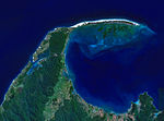
Tasman Bay (Māori: Te Tai-o-Aorere; officially Tasman Bay / Te Tai-o-Aorere), originally known in English as Blind Bay, is a large V-shaped bay at the...
5 KB (411 words) - 09:15, 8 June 2024

River. Mount Tasman. The Abel Tasman National Park. Tasman Bay. The Tasman District. Abel Tasman Monument. Also named after Tasman are: Tasman Pulp and Paper...
40 KB (4,811 words) - 21:35, 27 August 2024

the Tasman District Council, a unitary authority, which sits at Richmond, with community boards serving outlying communities in Motueka and Golden Bay /...
19 KB (1,413 words) - 09:34, 31 August 2024
Tasman (often known as the Tasman Mako and formerly Tasman Makos) are a New Zealand professional rugby union team based in Tasman Bay / Te Tai-o-Aorere...
15 KB (477 words) - 00:52, 1 September 2024
The Tasman Rugby Union is the governing body for rugby union in Tasman Bay / Te Tai-o-Aorere, a bay at the north end of the South Island in New Zealand...
33 KB (2,603 words) - 21:27, 31 August 2024

Tasman District Council in New Zealand. It lies 13 kilometres (8 mi) south of Nelson in the South Island, close to the southern extremity of Tasman Bay...
22 KB (1,490 words) - 03:46, 14 August 2024
Golden Bay / Mohua is a large shallow bay in New Zealand's Tasman District, near the northern tip of the South Island. An arm of the Tasman Sea, the bay lies...
34 KB (3,460 words) - 06:05, 20 July 2024

Tasman National Park is a national park at the north end of New Zealand's South Island. It covers 237.1 km2 (91.5 sq mi) of land between Golden Bay /...
17 KB (1,779 words) - 02:58, 13 August 2024
the north by Norfolk Bay, to the northwest by Frederick Henry Bay, to the west and south by Storm Bay, and to the east by the Tasman Sea. Many smaller towns...
10 KB (1,112 words) - 17:41, 24 May 2024
up Tasman in Wiktionary, the free dictionary. Tasman most often refers to Abel Tasman (1603–1659), Dutch explorer. Tasman may also refer to: Tasman booby...
3 KB (453 words) - 16:16, 4 January 2024
Nelson, New Zealand (category Populated places around Tasman Bay / Te Tai-o-Aorere)
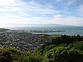
is a consolidated city and unitary authority on the eastern shores of Tasman Bay at the top of the South Island of New Zealand. It is the oldest city in...
104 KB (9,223 words) - 02:15, 2 September 2024

the park, the other being the Abel Tasman Inland Track, which stretches for 38 km between Tinline Bay and Torrent Bay off the main coastal track. The coastal...
14 KB (1,684 words) - 22:48, 25 February 2024

Rākauroa / Torrent Bay is a bay in Abel Tasman National Park, New Zealand. Torrent Bay was named by French explorer Dumont D'Urville during his exploration...
4 KB (331 words) - 05:54, 12 April 2024
Serpentine River (New Zealand) (category Tasman Bay)
of Richmond before joining the Roding River, eventually emptying into Tasman Bay. 41°24′S 173°12′E / 41.400°S 173.200°E / -41.400; 173.200 v t e v t...
763 bytes (66 words) - 17:56, 22 April 2024

French Pass (category Tasman Bay)
the South Island of New Zealand, from the mainland coast. At one end is Tasman Bay, and at the other end the outer Pelorus Sound / Te Hoiere leads out to...
11 KB (1,231 words) - 19:49, 30 December 2023

Tākaka (redirect from Takaka, Golden Bay)
Tākaka Hill, to Motueka (57 km away) linking Golden Bay with the more populated coast of Tasman Bay to the southeast. The town is served by Tākaka Aerodrome...
28 KB (2,655 words) - 02:02, 24 August 2024
Bay, Oahu Waimea Canyon State Park, Kauai Waimea Ditch, Kauai Waimea River (Kauai) Waimea River (Oahu) Waimea Valley, Oahu Waimea Inlet, Tasman Bay Waimea...
1 KB (203 words) - 22:45, 8 February 2024

Riuwaka River (category Tasman Bay)
northwest of New Zealand's South Island. It flows for 20 kilometres, entering Tasman Bay close to the town of Riwaka, 10 kilometres north of Motueka. The valleys...
4 KB (224 words) - 00:41, 14 April 2024

explorer Jules Dumont d'Urville arrived in Tasman Bay on the corvette Astrolabe. A number of landmarks around Tasman Bay were named by d'Urville and his crew...
106 KB (9,664 words) - 01:45, 24 August 2024

mouth at the Tasman Sea, midpoint between the suburbs of La Perouse and Kurnell. The northern headland of the entrance to the bay from the Tasman Sea is Cape...
24 KB (2,438 words) - 04:09, 13 August 2024
the Mataura River in Southland, New Zealand Waimea River (Tasman), flowing into Tasman Bay near Appleby This disambiguation page lists articles about...
356 bytes (86 words) - 21:27, 25 December 2015

Tonga Island (category Islands of Tasman Bay)
15 km2) island in Tasman Bay / Te Tai-o-Aorere, off the northern coast of the South Island of New Zealand. It lies within the Abel Tasman National Park,...
5 KB (252 words) - 11:09, 10 April 2024

Awaroa Inlet (category Bays of the Tasman District)
Awaroa Bay Awaroa Inlet is a remote, alluring body of water within the Abel Tasman National Park, at the northern end of Tasman Bay, in the Tasman Region...
13 KB (1,330 words) - 13:35, 10 July 2024

Wai-iti River, which meet near Brightwater. The combined waters flow into Tasman Bay / Te Tai-o-Aorere near Appleby, opposite Rabbit Island. "Environmental...
3 KB (84 words) - 02:47, 13 April 2024

Wai-iti River (category Rivers of the Tasman District)
Wairoa River to form the Waimea River. This flows into the southern end of Tasman Bay / Te Tai-o-Aorere near Richmond. The New Zealand Ministry for Culture...
1 KB (99 words) - 02:44, 13 April 2024
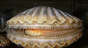
helped it recover, and catches in the 1990s were up to 684 tonnes. The Tasman Bay area was closed to commercial scallop harvesting from 2009 to 2011 due...
78 KB (8,422 words) - 17:27, 29 August 2024
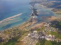
Motueka (category Populated places in the Tasman District)
mouth of the Motueka River on the western shore of Tasman Bay. It is the second largest in the Tasman Region, with a population of 8,320 as of June 2023...
45 KB (3,786 words) - 03:41, 3 September 2024

Kina Beach, a Tasman Bay / Te Tai-o-Aorere beach with rock pools which is only fully accessible during low tide. The population of Tasman Village and Kina...
14 KB (1,362 words) - 04:26, 21 April 2024

sunset on the water" for Rotokura. The bay itself is a 600 metres (2,000 ft) wide, northwest-facing bay in the Tasman Bay / Te Tai-o-Aorere. It lies just north...
8 KB (868 words) - 04:31, 14 September 2023
Bird Island is an island west of Moturoa / Rabbit Island in the Tasman District of New Zealand. List of islands of New Zealand Islands portal "NZGB Gazetteer"...
1 KB (41 words) - 04:17, 4 September 2023