
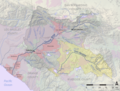
Temescal Valley (Temescal, Spanish for "sweat lodge") is a census-designated place in Riverside County, California. Temescal Valley sits at an elevation...
17 KB (1,525 words) - 15:59, 4 October 2024
Temescal Valley may refer to: Temescal Valley (California), in western Riverside County, California, a part of the Elsinore Trough. Temescal Valley, California...
295 bytes (63 words) - 01:40, 22 October 2013
Temescal Valley Los Angeles San Diego Temescal Valley (Temescal, Spanish for "sweat lodge") in California is a graben rift valley in western Riverside...
2 KB (283 words) - 12:04, 4 March 2024
State Route 71 Temescal Mountains Temescal Valley (California), a valley Temescal Valley, California, a census-designated place Temescal Butterfield stage...
1 KB (173 words) - 13:55, 24 September 2022

Two years following the construction of this mission outpost, the Temescal Valley's first European resident, Leandro Serrano, was given permission by...
70 KB (5,336 words) - 02:31, 21 October 2024

from which it is separated by the Temescal Valley and Elsinore Valley sections of the Elsinore Trough. The Temescal Mountains were originally considered...
18 KB (2,527 words) - 02:25, 6 September 2024

extended along the Temescal Valley south of present-day Corona and encompassed El Cerrito and Lee Lake. At the time, Rancho Temescal was a part of San...
20 KB (2,678 words) - 21:08, 15 October 2024

Lake, Corona, Eastvale, Lake Elsinore, Menifee, Norco, Riverside, Temescal Valley, and Woodcrest. Essayli's parents are immigrants from Lebanon who fled...
6 KB (368 words) - 23:29, 2 October 2024
housing developments and agricultural return flows. Prior to 1886, Temescal Valley and Temescal Creek that flowed through it had much more water than today....
13 KB (1,841 words) - 15:13, 28 March 2024

California's 41st congressional district (category Moreno Valley, California)
places Cherry Valley, Nuevo, Homeland, Sage, Idyllwild-Pine Cove, Woodcrest, Coronita, El Sobrante, El Cerrito, Lake Mathews, Temescal Valley, Warm Springs...
55 KB (1,309 words) - 05:32, 14 October 2024

Pinyon Pines Radec Rancho Capistrano Ripley Romoland Sage Sky Valley Snow Creek Temescal Valley Thermal Thomas Mountain Thousand Palms Valle Vista Vista Santa...
138 KB (5,880 words) - 06:58, 19 October 2024
of Banning, Beaumont, Corona, Canyon Lake, Riverside, Temescal Valley, Woodcrest, Moreno Valley, Perris, Menifee, Lake Elsinore, Wildomar, Murrieta, Temecula...
6 KB (557 words) - 04:08, 7 October 2024

rural zones in the eastern Santa Ana foothills near Lake Elsinore and Temescal Valley. On September 12, authorities lifted the mandatory evacuations in Rancho...
19 KB (1,554 words) - 03:18, 8 October 2024

Elsinore Trough (category Valleys of Riverside County, California)
Mountains to the west, and the Temescal Mountains of the Perris Block and the Temecula Basin to the east. This graben valley is broken into a series of sections...
2 KB (196 words) - 22:44, 11 March 2024
Coronita, El Cerrito, Home Gardens, Lake Mathews and Temescal Valley, and a small portion of Jurupa Valley. It is the largest public school district in Riverside...
5 KB (378 words) - 03:46, 7 October 2024
Lee Lake, is a reservoir created by the Lee Lake 818-002 Dam across Temescal Creek, in Riverside County, California. It lies at an elevation of 1,122 feet...
5 KB (274 words) - 18:03, 6 April 2023

south of the Elsinore Valley, from which it is divided by a low rise between the Temescal and Santa Ana Mountains. The valley is drained by Murrieta...
4 KB (265 words) - 06:03, 27 April 2024
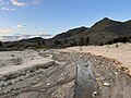
Temescal Canyon (Temescal, Spanish for "sweat lodge") is the canyon below the mouth of Temescal Valley, carrying Temescal Creek, through the hills in...
651 bytes (88 words) - 15:08, 15 October 2021

Elsinore Valley. The Luiseño people were the earliest known inhabitants. Their pictographs can be found on rocks on the Santa Ana Mountains and in Temescal Valley...
70 KB (7,447 words) - 01:03, 19 October 2024

to the mountainous countryside. Only Francisco Lopes, owner of Rancho Temescal, a Mexican land grant, and a handful of ranchers attempted to settle the...
9 KB (772 words) - 06:19, 18 September 2024

Interstate 15 in California (redirect from Temecula Valley Freeway)
Hemet, Idyllwild, and the Coachella Valley. It continues northwest through the unincorporated area of Temescal Valley as the Corona Freeway and passes through...
59 KB (4,225 words) - 14:48, 21 October 2024
Pinos and Lucerne transverse faults, dividing the Elsinore Valley from the Temescal Valley graben. Rene Engel, GEOLOGY AND MINERAL DEPOSITS OF THE LAKE...
2 KB (278 words) - 22:41, 11 March 2024
Estelle Mountain (category Temescal Mountains)
the tallest in the Temescal Mountains. It is located on the west side of the upper part of the range overlooking the Temescal Valley, in Riverside County...
2 KB (150 words) - 23:32, 10 July 2024
Springs Valley is a valley located within the city of Lake Elsinore in Riverside County, California. It lies between the main body of the Temescal Mountains...
2 KB (258 words) - 17:39, 6 April 2024

of the discovery a then-missing person's body. Puente Hills San Gabriel Valley California Floristic Province California chaparral and woodlands Puente...
8 KB (759 words) - 00:14, 14 January 2024

year, the state of California evicted the Payómkawichum in the Temecula Valley to be redistributed to American ranchers. In 1882, another round of reservations...
24 KB (2,294 words) - 02:05, 17 October 2024
Eagle Valley is a basin in the Temescal Mountains, of Riverside County, California. It has an elevation of 1,283 feet (391 meters). The basin is overlooked...
1 KB (174 words) - 17:49, 22 January 2023

California Ranchos Ranchos of Los Angeles County, California Temescal Valley (California) Temescal Creek (Riverside County) Santa Ana Mountains List of tributaries...
9 KB (922 words) - 11:03, 27 July 2023
Temescal Canyon High School is a public high school part of the Lake Elsinore Unified School District. Though it is located in Lake Elsinore, California...
14 KB (1,897 words) - 00:43, 22 August 2024

California State Route 71 (redirect from Temescal Freeway)
formerly the Corona Expressway and before then the Temescal Freeway. SR 71 is designated as the Chino Valley Freeway between SR 83 and the Kellogg Interchange...
16 KB (1,368 words) - 01:28, 20 October 2024