
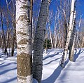
Tiadaghton State Forest (/ˌtaɪəˈdɑːtən/; ty-ə-DAH-tən) is a Pennsylvania State Forest (Forest District #12) in the Pennsylvania Department of Conservation...
12 KB (1,074 words) - 15:58, 16 July 2023

the Tiadaghton State Forest. It is on Upper Pine Bottom Run, which gave the park its name and is a tributary of Pine Creek. Upper Pine Bottom State Park...
56 KB (6,086 words) - 07:19, 12 February 2023

Tioga State Forest was shut down in 1972. The U.S. state of New York is to the north Loyalsock State Forest (east and southeast) Tiadaghton State Forest (south)...
9 KB (812 words) - 07:13, 12 February 2023

Rothrock State Forest and on its northern extent with Tiadaghton State Forest. Five Pennsylvania State Parks are contained within the forest: Poe Valley...
10 KB (812 words) - 23:57, 31 March 2024
in Lycoming County, Pennsylvania, United States. It is part of Tiadaghton State Forest. Torbert Island itself is 14 acres in size, and the protected area...
3 KB (182 words) - 15:21, 11 May 2024

trending primarily to the north, the MST passes into Tiadaghton State Forest, walks through Ravensburg State Park, and crosses PA Route 880. North of that park...
13 KB (1,448 words) - 19:15, 28 March 2024

Mountain. Ravensburg State Park is 78 acres (32 ha) of wooded land that is almost entirely surrounded by Tiadaghton State Forest. This state park is on Pennsylvania...
12 KB (982 words) - 01:30, 3 August 2023

Black Forest Trail is a 43.0-mile (69.2 km) hiking trail in north-central Pennsylvania, forming a loop through portions of Tiadaghton State Forest and routed...
8 KB (1,040 words) - 14:13, 16 May 2024

Little Pine State park is along 4.2 miles (6.8 km) of Little Pine Creek, a tributary of Pine Creek, in the midst of the Tiadaghton State Forest. A dam on...
34 KB (3,553 words) - 21:01, 27 May 2024

2012, is a picnic area surrounded by Tiadaghton State Forest. These state forest lands were acquired by the state by the early 1900s, the site was "Upper...
108 KB (3,537 words) - 20:14, 7 June 2024
in Lycoming County, Pennsylvania, United States. It is part of Tiadaghton State Forest, and is the second-largest designated Natural Area in Pennsylvania...
2 KB (171 words) - 15:20, 11 May 2024

postscript (link) "Tiadaghton Hiking". Pennsylvania Department of Conservation and Natural Resources. Retrieved 2021-01-24. The Black Forest Trail is a 42-mile...
42 KB (537 words) - 19:55, 28 June 2024

between Ansonia and Blackwell. Tioga State Forest Tiadaghton Blackwell (Morris Township) Tiadaghton State Forest Cedar Run (Brown Township) Slate Run...
13 KB (1,143 words) - 01:11, 30 May 2024
Forest (southwest) Bald Eagle State Forest (west) Tiadaghton State Forest (northwest) Worlds End State Park Jakey Hollow Natural Area "Wyoming State Forest"...
5 KB (338 words) - 07:14, 12 February 2023
Resources. Retrieved 2023-12-16. Fergus, p. 63-67 Fergus, p. 143-146 "Tiadaghton State Forest Wild and Natural Areas". Pennsylvania Department of Conservation...
22 KB (734 words) - 14:37, 6 July 2024
in Lycoming County, Pennsylvania, United States. It is part of Tiadaghton State Forest. The Natural Area protects a copse of naturally occurring and unplanted...
2 KB (127 words) - 14:30, 11 May 2024

Denholm in Juniata County. From 1900 to 1935, much of what is now Tiadaghton State Forest was purchased by Pennsylvania from lumber companies that had no...
19 KB (1,675 words) - 05:19, 10 February 2024

and Tioga Counties, Pennsylvania, United States. It is part of Tiadaghton State Forest, and has also been named a National Natural Landmark. The Natural...
3 KB (210 words) - 13:52, 11 May 2024

Pennsylvania Route 44 (redirect from Pennsylvania State Route 44)
farm fields with some development before it enters a tract of the Tiadaghton State Forest and heads west to ascend North White Deer Ridge, one of the ridges...
35 KB (3,280 words) - 03:21, 14 August 2024
given to agriculture and 71.6 percent covered by forest, including part of Tiadaghton State Forest. The western part of White Deer Hole Creek has very...
55 KB (6,135 words) - 01:02, 11 April 2024

in Lycoming County, Pennsylvania, United States. It is part of Tiadaghton State Forest. The Natural Area protects a copse of old growth trees, including...
2 KB (136 words) - 14:12, 11 May 2024

Creek, which flows southwestward to the West Branch at North Bend. Tiadaghton State Forest occupies much of the township. As of the census of 2000, there...
13 KB (1,256 words) - 22:39, 19 December 2023

stands today. Tiadaghton State Forest lands were acquired by the state by the early 1900s. The site which became the Upper Pine Bottom State Park was the...
15 KB (1,318 words) - 22:42, 19 December 2023
Pennsylvania state forests in Lycoming County: Tiadaghton State Forest in the southern and western parts of the county, Loyalsock State Forest in the eastern...
37 KB (2,695 words) - 09:17, 9 August 2024

Tsuga canadensis (category Hardwood forest plants)
is 44 m (144 ft). This tree, named the Seneca hemlock, grows in Cook Forest State Park, PA. Above 43°N latitude, the maximum height of the species is less...
24 KB (3,229 words) - 00:59, 25 May 2024

Pinchot State Forest (east) Weiser State Forest (south) Tiadaghton State Forest (southwest) Tioga State Forest (northwest) Worlds End State Park Ricketts...
14 KB (1,380 words) - 22:50, 14 January 2024

OCLC 35920715. Owlett, Steven E. (1993). "The Death of a Forest". Seasons Along The Tiadaghton: An Environmental History of the Pine Creek Gorge (1st ed...
20 KB (2,275 words) - 15:15, 5 March 2024

Susquehannock State Forest to the north Tiadaghton State Forest to the east Bald Eagle State Forest to the southeast Rothrock State Forest to the south...
11 KB (1,162 words) - 17:09, 6 August 2023

north-central Pennsylvania, through portions of Sproul State Forest and Tiadaghton State Forest. For most hikers, the T-Squared Trail serves as a connection...
4 KB (518 words) - 11:39, 18 May 2024
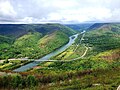
western border divided colonial Pennsylvania and Indian Country along Tiadaghton Creek. The colonial government claimed this was Pine Creek, the Kanien'kehá:ka...
7 KB (652 words) - 03:27, 1 June 2024