
Tryne Islands The Tryne Islands are a group of numerous small Antarctic islands and rocks, about 7 km (4 mi) in extent, forming the western limit of Tryne...
3 KB (284 words) - 16:06, 21 August 2021
wide at the northeast end of the Vestfold Hills, lying between the Tryne Islands and the coast. Charted by Norwegian cartographers from air photos taken...
504 bytes (85 words) - 12:22, 2 February 2020
Trundy Island Tryne Islands Tsankov Island Tsiolkovskiy Island Tukey Island (64°46′S 64°26′W / 64.767°S 64.433°W / -64.767; -64.433) Tupinier Islands Tupman...
74 KB (12,543 words) - 12:46, 3 October 2024

Wilhelm Archipelago, to the northeast of the Vedel Islands and southwest of the Wauwermans Islands. It is separated from the mainland by the Lemaire Channel...
21 KB (3,310 words) - 23:38, 11 August 2024
'Point Nemo', the other two being Ducie Island, one of the Pitcairn Islands, and Motu Nui near Easter Island. It has numerous areas of exposed rock and...
3 KB (228 words) - 00:59, 17 October 2024

in the Wilhelm Archipelago, southwest of Hovgaard Island and Booth Island, east of the Vedel Islands and northeast of the French Passage. It is northwest...
14 KB (1,941 words) - 23:44, 11 August 2024
Cove List of Antarctic islands south of 60° S "Dream Island". Australian Antarctic Program. Retrieved 25 June 2024. "Dream Island". BirdLife data zone:...
4 KB (295 words) - 19:40, 6 October 2024

168286°E / -77.552929; 166.168286) is a historical site near Cape Royds, Ross Island, Antarctica, where the explorer Ernest Shackleton built a hut that housed...
7 KB (625 words) - 13:06, 5 February 2024

James Ross Island to the north-east by Admiralty Sound and from Seymour Island to the north by Picnic Passage. It is one of several islands around the...
10 KB (1,280 words) - 15:28, 2 October 2024

Proclamation Island Kemp Land Pole of Inaccessibility research station Mac. Robertson Land Cape Bruce Princess Elizabeth Land Tryne Islands Vostok Station...
33 KB (3,257 words) - 03:53, 28 August 2024

Sturge Island is one of the three main islands in the uninhabited Balleny Islands group located in the Southern Ocean. It lies 25 km (16 mi) southeast...
4 KB (301 words) - 19:26, 5 January 2024

close off the south-west end of King George Island, in the South Shetland Islands of Antarctica. It was charted as a peninsula in 1935 by Discovery Investigations...
6 KB (570 words) - 10:47, 19 November 2023
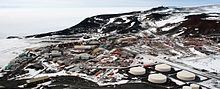
McMurdo Station (redirect from Ross Island Yacht Club Antarctica)
Station is an American Antarctic research station on the southern tip of Ross Island, which is in the New Zealand–claimed Ross Dependency on the shore of McMurdo...
37 KB (3,123 words) - 07:31, 23 September 2024

Argentine shore party fired a machine gun over the heads of a Falkland Islands Dependencies Survey team unloading supplies from the John Biscoe to rebuild...
24 KB (1,696 words) - 01:18, 1 June 2024

Proclamation Island Kemp Land Pole of Inaccessibility research station Mac. Robertson Land Cape Bruce Princess Elizabeth Land Tryne Islands Vostok Station...
15 KB (1,125 words) - 15:50, 13 May 2024

Mount Erebus (category Volcanoes of Ross Island)
(/ˈɛrɪbəs/) is the southernmost active volcano on Earth, located on Ross Island in the Ross Dependency in Antarctica. With a summit elevation of 3,792 metres...
40 KB (5,708 words) - 06:16, 14 October 2024

Base is a New Zealand Antarctic research station at Pram Point on Ross Island near Mount Erebus in New Zealand's Ross Dependency territorial claim. It...
24 KB (1,914 words) - 19:15, 22 September 2024

Port Lockroy (category Wiencke Island)
Wiencke Island in the Palmer Archipelago to the west of the Antarctic Peninsula. The Antarctic base with the same name, situated on Goudier Island in this...
8 KB (696 words) - 19:08, 16 October 2024
Tryne Fjord Tryne Fjord is an irregular-shaped fjord that idents the northern side of Langnes Peninsula in the Vestfold Hills. Mapped and named Tryne...
1,002 bytes (84 words) - 18:09, 1 September 2024

Gardner Island is a largely ice-free island which lies about 3 km west of Broad Peninsula in the southern Vestfold Hills, in Prydz Bay on the Ingrid Christensen...
2 KB (106 words) - 02:34, 9 October 2022

Lucas Island Lugg Island Magnetic Island Rookery Lake Tryne Islands Turner Island Warriner Island Waterhouse Island West Ice Shelf Zolotov Island Queen...
12 KB (1,269 words) - 21:50, 28 June 2024
the landing party from the Thorshavn—and thus Mikkelsen—landed on the Tryne Islands where a marker at Mikkelsen's Cairn can still be seen today. The landing...
9 KB (746 words) - 16:52, 20 February 2024

Cape Crozier (category Headlands of Ross Island)
1983 George Seaver: Edward Wilson of the Antarctic, John Murray 1940 edition Portals: Birds Islands Environment Geography Earth sciences Water Weather...
13 KB (1,571 words) - 04:48, 29 May 2024
seen on sea ice near the island. Composite Antarctic Gazetteer List of Antarctic and Subantarctic islands List of Antarctic islands south of 60° S SCAR Territorial...
8 KB (848 words) - 14:25, 17 October 2024

Penguin Island (also known as Georges Island, Île Pingouin, Isla Pingüino, and Penguin Isle) is one of the smaller of the South Shetland Islands of Antarctica...
6 KB (475 words) - 16:59, 6 April 2024

Antarctic islands south of 60° S Secretariat of the Antarctic Treaty Visitor Site Guidelines and island description Images from Cuverville Island Archived...
3 KB (197 words) - 07:31, 1 January 2024

subantarctic islands List of volcanoes in Antarctica "Paulet". Global Volcanism Program. Smithsonian Institution. "Geological Map of James Ross Island" (PDF)...
7 KB (536 words) - 16:37, 2 October 2024

Subantarctic islands List of Antarctic islands south of 60° S Scientific Committee on Antarctic Research Territorial claims in Antarctica "Smyley Island". Geographic...
3 KB (251 words) - 01:45, 5 October 2024

2009 satellite imagery. Composite Antarctic Gazetteer List of Antarctic islands south of 60° S SCAR Territorial claims in Antarctica "Flichner Ice Shelf"...
8 KB (780 words) - 17:26, 29 July 2024

Proclamation Island Kemp Land Pole of Inaccessibility research station Mac. Robertson Land Cape Bruce Princess Elizabeth Land Tryne Islands Vostok Station...
9 KB (758 words) - 19:03, 4 May 2024